|
|
Route |
|---|---|
|
|
40.41620°N / 111.6669°W |
|
|
Mountaineering |
|
|
Spring, Winter |
|
|
A long day |
|
|
40 degree snow |
|
|
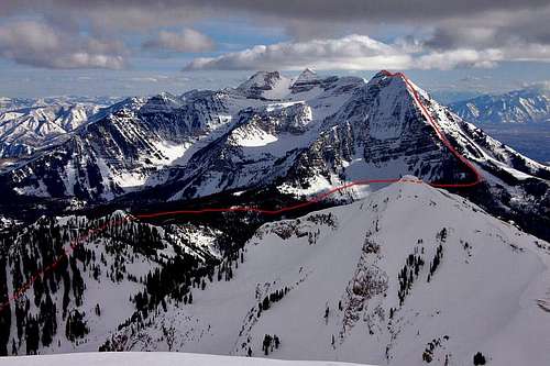
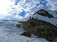
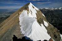
Overview
Cold Fusion Couloir is a fantastic snow climb up the north aspect of North Timpanogos. While most commonly traveled as a ski-mountaineering descent, Cold Fusion Couloir is a strenuous and beautiful climbing route with an uninterrupted 2,500-3,000 foot glissade (depending on snowpack depth).ATTENTION: It is important to note that Cold Fusion Couloir is a steep, dangerous, and avalanche prone region of the Timpanogos massif. Only attempt this route under safe conditions and with proper knowledge and experience in avalanche terrain.
Click for the Full Trip Report on my photography website.
Getting There
Take I-15 to the Highland/Alpine Exit (#287), turn east onto UT-92. Continue east on this highway and you will arrive at the mouth of American Fork Canyon. There is a Forest Service Toll Booth and a $3.00 fee for a three-day pass on the road.From the mouth of American Fork Canyon, go 4.8 miles up the Alpine Loop road to a large fork in the road. Take the right fork and continue 1 mile to the entrance of Mutual Dell, a youth camp. Gates close the parking lot during the winter and spring, so just park on the side of the road outside of the gates.
Route Description


Locating the base of the couloir can be tough in the dark. Here's an experience from seanpeckham that is helpful:
"Where the couloir reaches the road, it is a small gully. I was expecting something larger and in the dark we failed to notice it. According to the GPS we were very near it, though, so we bushwhacked up until we found it. On the way down, I took a waypoint for the entrance: 40º25.692' N, 111º40.921 W. This is where the 7.5' quad shows the stream, right where the road starts to head NW again after the "horseshoe turn"; if you are heading WNW, you have gone too far."

The lower half of the couloir is an easy 25-30 degrees with no obsticles.
The middle half of the couloir has numerous cliffs that are easy to navigate with 30-40 degree slopes.
The upper half of the couloir is a constant 40 degrees, with some 3rd class rock scrambling depending on the snowpack. The couloir is wide and will supply different slope pitches depending on the line you choose. Local guidebooks record the pitch between 35-40 degrees and as high as 50 degrees. SPers have measured it at 40 degrees, give or take a few degrees.
The first peak you reach is a false summit noted as Point 11,383.
From the false summit, continue a short distance along the north ridge to the true summit at 11,441 feet. There is a small rock band along the north ridge with a 10-foot 3rd class section. Other than that, it's 2nd class terrain. Again, with this rock band, you can find spicier lines of 4th class is desired.
As fun as the ascent can be, the true beauty is in the ski descent or glissade. 2,500-3,000 vertical feet of steep, uninterrupted slope (depending on snowpack depth).
Ski ascent observation from Betacom:
If you are skinning up CFC,there is nice skin track ascending up the the NW aspect tree line staying outside of the couloir. from the start gully of CFC on Timpooneke Road, continue up road around corner were the pine forest disappears and opens to an apron, Skin track ascends up and left through the lower NW apron, staying near the edge of CFC. We initially skinned up the main CFC gully before cutting over to the NW skin track around 1000'. Skin track seemed safe and protected in the tree line, less exposure than going straight up the couloir?
![Cold Fusion Couloir]()
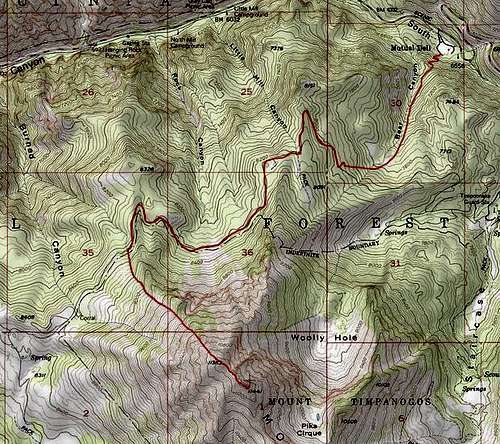
Bear Canyon Trail to Timpooneke Road
Distance: 2 mi.
Elevation Increase +1,442'
Timpooneke Road to base of Cold Fusion Couloir
Distance: 2.8 mi.
Elevation Increase +410'
Cold Fusion Couloir to The Summit
Distance: 1 mi.
Elevation Increase +3,031'
Route Total (one way)
Distance: 5.8 mi.
Elevation Increase +4,883'
![Cold Fusion Couloir]()
Route Stats

Distance: 2 mi.
Elevation Increase +1,442'
Timpooneke Road to base of Cold Fusion Couloir
Distance: 2.8 mi.
Elevation Increase +410'
Cold Fusion Couloir to The Summit
Distance: 1 mi.
Elevation Increase +3,031'
Route Total (one way)
Distance: 5.8 mi.
Elevation Increase +4,883'
Essential Gear
Axe, crampons, helmet, and clothing for cold weather climbing.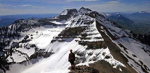
seanpeckham - Jun 1, 2008 2:41 pm - Voted 10/10
just some notes from our tripWhere the couloir reaches the road, it is a small gully. I was expecting something larger and in the dark we failed to notice it. According to the GPS we were very near it, though, so we bushwhacked up until we found it. On the way down, I took a waypoint for the entrance: 40º25.692' N, 111º40.921 W. This is where the 7.5' quad shows the stream, right where the road starts to head NW again after the "horseshoe turn"; if you are heading WNW, you have gone too far. Also, according to Bradley's Backcountry Skiing Utah, upper CFC is only 35-40º, not 42+, and I would agree based on my observations; however, the very top has sections which I measured at 45+, but it is partly a function of snow coverage. Finally, there is no 4th class, unless you go out of your way to take the hard way through the cliff band. There are several notches which are 3-minus at most, but look harder from a distance.
marauders - Jun 2, 2008 12:59 am - Hasn't voted
Re: just some notes from our tripI appreciate the input, so much of what you write in a TR comes directly from your line, which others will not likely follow. So each experience is a bit different. The gully is very small and we missed it too the first time in the dark. The upper CFC angle as you commented is reported from 35-40 in Bradley's book to 50 in Wasatch Tours III. Our measurement was 42-degrees and steeper depending on exactly where you exited the couloir. I'll update the CFC page with your obs. The 4th class is in the cliff band below the North summit. As you mentioned, it all depends on what line you take. You can make it easy or spicey. I'll update that as well.
seanpeckham - Jun 2, 2008 1:28 pm - Voted 10/10
Re: just some notes from our tripIn calling my post "just some notes" I hoped to make it out to be more of an "addition" than a "correction", because who is to say that my measurement or yours is the most accurate? As we agree it depends on the time and the line. I just thought I'd throw out my obs as additional data. I believe the 50º too. My measurement of 45 was rough and just an average over perhaps as many as a dozen ski turns, and it rolled over steeper than that in spots. What an awesome route! My agreement with the 35-40 a bit lower down is based on subjective judgment on my part; didn't measure it. I have to say, thanks a lot for your page, descriptions, and photos; I never would have known about this and it's because you made it look so good (and deservedly so) that I got the ambition to do it.
marauders - Jun 5, 2008 8:31 pm - Hasn't voted
Re: just some notes from our tripNo worries at all, I didn't take it as a "correction". I appreciated the input because I want to put forth the best info that can be gather by each perspective.
Betacom - Apr 27, 2013 3:07 pm - Hasn't voted
CFC trip notesSplitboard descent 4/24/13, As not mentioned in the initial route description; If you are skinning up CFC,there is nice skin track ascending up the the NW aspect tree line staying outside of the couloir. from the start gully of CFC on Timpooneke Road, continue up road around corner were the pine forest disappears and opens to an apron, Skin track ascends up and left through the lower NW apron, staying near the edge of CFC. We initially skinned up the main CFC gully before cutting over to the NW skin track around 1000'. Skin track seemed safe and protected in the tree line, less exposure than going straight up the couloir?
marauders - May 10, 2013 12:27 pm - Hasn't voted
Re: CFC trip notesI added your notes to the main page. Thanks.