
|
|
Route |
|---|---|
|
|
43.22044°N / 109.54794°W |
|
|
Hiking |
|
|
Summer |
|
|
A few days |
|
|
Moderate |
|
|
Overview
 Gannett Peak
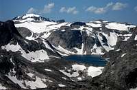 Klondike Lake
This is really a new route to get to an existing route. The main route to Mount Febbas is via a 10 mile hike each way from the Ink Wells Trail at Scenic Pass, atop Horse Ridge. This route shaves a few miles off that, assuming you find yourself in the upper reaches of the Dry Creek drainage. It’s a little shorter at approx. 6.8 miles each way and if nothing else, shows that there are a few different ways to access the top of Horse Ridge.
Getting There
This area is hard to reach and unlike most routes, the crux of this one may well be in the getting there. The most direct and shortest approach would be from the Cold Springs Trailhead on the Wind River Indian Reservation. The distance from Cold Springs to where this route starts is approx. 8.6 miles. The Ink Wells Trail via the Glacier Trail also provides access to the Dry Creek drainage.Route Description
 Route from Don Lake to Horse Ridge
 Path of least resistance to the ridge-top
From Don Lakes east side, cross the outlet stream, proceeding north toward the eastern extension of Horse Ridge. Wind around the west side of a shallow lake then turn more eastward, aiming toward the gap in the trees on the ridge. Picking the path of least resistance, continue NE, with the goal being to crest the ridge at the gap. Turn northward, then westward after crossing the ridge, winding through rock outcroppings and small meadows until you pass point 11,165. Turning south, take the ramp up to the ridge, staying west of 11,165. From there, head west, passing between slightly higher rockpiles until you find yourself facing a higher, north/south ridge, with snow fields just below the crest. The distance to this point is approx. 2.5 miles from the start and 1,500 ft. elevation gain.
Turn south and follow the natural line of the ridge to the left of Knoll Lake and on to the ridge’s highpoint, Mount Febbas.
The biggest danger on this route as with Horse Ridge in general, is exposure. Recommend an early start and keep a vigilant eye on the weather. If you get caught on top when storms approach, it’s a very long, exposed way to the safety of the lower slopes below.
Essential Gear
Full backpacking gear to access and set up a base camp.Head-nets, mosquito repellant and pepper spray strongly recommended.
Ice axe could be a plus early in the season (before August).