
|
|
Route |
|---|---|
|
|
36.18337°N / 112.37606°W |
|
|
Hiking, Canyoneering |
|
|
Summer, Fall |
|
|
Expedition |
|
|
Class 3 |
|
|
Strenuous |
|
|
Overview - 5 Day Loop in Grand Canyon
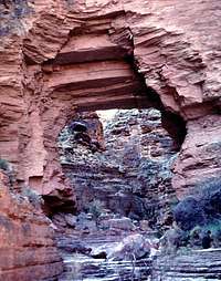
The Royal Arch
* This is NOT a beginner's trip - please read warnings below *
The royal arch loop is an epic backpacking/canyoneering trip in the Grand Canyon, and the only loop in the canyon. And once you get to the river it is a one way trip, because it involves a 20-foot rappel a few days in. This trip involves some strenuos work and some serious pathfinding. Poor map reading can leave you in some precarious situations in sweltering heat with no water and a lot of stress. Finding water is challenging, though not impossible. While the trip as a whole is an absolutely magnificant way of seeing the grand canyon (you may not see another hiker the entire time!), two particular highlights are the natural Royal Arch and Elves Chasm.
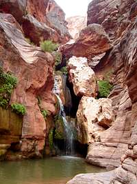
Elves Chasm
Getting There

Road to Trailhead from GC Village (High Res Compound Sat Map)
Getting there is no easy task. 4x4 vehicles are essential for the 2hr, 20 mile adventurous road from Grand Canyon village to the South Bass Trailhead. (Someone people were turned away simply by the road, if it has rained before driving it.) This trailhead is so far off the beaten path that park rangers in GC village will give you blank stares if you ask for the Southbass trailhead or Royal Arch Loop. Rad!
Here are some detailed instructions borrowed from Todd's Hiking Guide.
From Flagstaff follow US 180 northwest until you reach the cheesy Flintstone town of Bedrock. Turn north (right) onto Highway 64 (which is also 180) to the south entrance of the Grand Canyon. Drive into the park and follow the signs towards the Grand Canyon Village. Follow the main road past the Bright Angel Lodge until you reach Maswik Lodge. Turn right after passing the lodge and drive around back to a paved road which leads to the kennels. Follow the signs to the kennels, but drive past it until you cross the railroad tracks, turn left onto Rowe Well Road. After a short distance the road becomes dirt (or mud, it is highly reccomended that you have a 4-wheel drive vehicle to proceed on this road, it may look easy enough when dry, but after a rain it becomes a treacherous mud wallow). Turn left on Rowe Well Road and drive south for approximately 3 miles to the park boundary.
You are now in the Kaibab National Forest and on FS road #328A. Continue on 328A for approximately one mile to FS #328. Turn right at the intersection. There is a sign indicating Tusayan (6 miles) to the left and Pasture Wash to the right. Turn right and continue west on #328 for approximately 15.6 miles to the Havasupai Nation's boundary (there is a cattle gaurd and 'No Trespassing' sign posted here). Supposedly the boundary is sometimes staffed by Havasupai rangers who will gouge you $25 to drive through their land (there are several closed roads to Pasture Wash that do not pass through indian land, the Park Service should re-open these roads so hikers are not subjected to this nonsense). If no ranger is present, there's nothing stopping you from proceeding ahead.

Road to Trailhead from GC Village (Satellite)
Once inside the reservation, continue approximately 1.7 miles to an unmarked fork. A short distance down the right fork two upright posts are visible. Take the right fork, but do not drive through the posts, instead take a 90 degree right just before them heading north. After driving 1.9 miles you will reach the boundary with the Kaibab Forest again, another 1/2 mile will bring you to the park boundary (marked with a cattle gaurd and gate - please close the poorly constructed gate behind you). Two more miles brings you to the old, boarded up Pasture Wash Ranger Station - you can park here and walk the remaining 3.6 miles to the trail head if the road is deep mud, or continue on to the South Bass Trailhead and park.
Red Tape
Permits are required from the GC backcountry office (Fax 928 638 2125). Check in with them months in advance. It costs $10/person + $5/person/night (example 6 people, 6 nights = $320). The permit requires that you include the areas/campsites you will use. A prospective plan is to make your first night at "SE3 (SE1 or SE2)" (on top of the rim at the Southbass trailhead), then 4 nights at "Royal Arch at large" and last night at "south bass" (you can camp on the esplanade).
Route Description
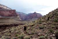
Tonto Trail

Trail Map
As seen on the map, the route starts by taking you down the Royal Arch drainage and hits the Colorado, where you take the Tonto Trail east, exiting via the Southbass trail.
**More details to come. For now, please see links to other trip reports below.**
** Cautionary Notes **
The biggest two factors that will get your nerves going are:
* route finding
* water
Believe it or not, the Grand Canyon is *hot*! Especially deep down in those canyons with minimal shade. One important rule is to wake up early, hike when it's cooler, and rest during those peak hot noon hours. The writers of this page ended up breaking this rule almost everyday because of the challenges brought on by route finding in the canyon and pumping water.
Regarding route finding, don't try to make your own path. It is easy to overestimate how far you've gone. When it comes down to it, you should either see a clear trail or cairns spaced relatively close together. It will hurt to stop in that brutle sun, but you should definitely do it if it means double-checking with your map that you're where you think you are. Trianglulate. Use a compass. Or of course, bring a GPS, which we wished we had multiple times.
Regarding water, make sure you bring VERY GOOD FILTERS and *lots* of chlorine drops or iodine. The water you will get from stagnant pools (or "potholes"), or from the colorado will be brown. Your filters will clog and you better make sure you know how to keep them in very good working condition or your trip may up end up really badly. Even in death. Pumping as much water as you need takes a lot of time so be sure to allow for that in your planning. Some additional reading on water in the GC can be found here.[After analysis of the many filters brought on our trip, the winner was the MSR Miniworks. Which has a ceramic filter which is relatively easy to remove dirt/mud from in the field.]
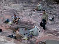
Pumping water
Another *fun little trick* the canyon plays on you is should you leave the Colorado without filling up, the first water you may hit is in the Garnett canyon, which in itself would not be a problem if it weren't the SALTIEST WATER ON EARTH. It will look crystal clear compared the frog-infested water you pumped from earlier in the trip and now you know why that is: nothing can survive in it. Keep walking. Hopefully you will find water in copper canyon.
Not to be ignored also are:
* rattle snakes (they lunge)
* scorpions
* scrambling
* some exposure (especially if you take "the ledge")
Tales from the Canyon:
"While many people fail to complete the Royal Arch Route for various reasons related to those above. We were able to finish. Although we were making such slow progress that we (a) skipped the Royal Arch, (b) some of us skipped Elves Chasm to use the time to rest and purify water and re-hydrate, and (c) started an all-nighter one night, leaving camp at 10:30pm to hike in the cool and get some more miles behind us."
Essential Gear
* G P S *
Unless you really want to live on the edge, or an experienced canyoneer, learn from our experience and buy a GPS.
* Bear buckets *
No, not for bears. Those puppies can be life-savers when you finally get down to the river after a repel in the dark, thirsty, and out of water, to find that the river water is completely brown. Fill all your buckets with water and let them settle (a few hours is all it takes) so you can filter off the top.
* Good functional filters *
Highly recommended are the ceramic filters such as MSR Miniworks or Katadyn Vario Microfilter, which allows for cleaning off mud/dirt and self-maintenance.
* Printed trip reports from other people (such as ours from Sept 2006)*
The details may help you find water and route.
* Appropriate gear for the rappel *
Although if you do it in the daytime, you could use the knotted rope that's already set up there.
* Gatorade Powder *
At least one plastic container (~16ounces?) per person. You won't want to eat. Warm stale water and ironically, sometimes you won't even like water. Gatorade WILL help you get down some calories and liquids. Another trick for getting liquids in is making your meals extra soupy.
External Links
Here is a trip report from my group.
Here are a few other reports we found that may be useful:
LINK #1
LINK #2
LINK #3
LINK #4
LINK #5
Have fun! It's truly amazing!