
-
 7967 Hits
-
 76.66% Score
-
 7 Votes
|
|
Route |
|---|---|
|
|
47.42473°N / 10.31540°E |
|
|
Download GPX » View Route on Map |
|
|
Hiking |
|
|
Summer, Fall |
|
|
Half a day |
|
|
Hike |
|
|
Overview
 On the Rubihorn south ridge On the Rubihorn south ridge |
Thanks to its exposed location high above the Iller Valley, Rubihorn is one of the most popular hiking destination of the Allgäu Alps. There are two equally popular routes, one from Reichenbach across Gaisalpe from the north and east, one from Oberstdorf across Seealpe from the south and west. The latter, which is described here, can be significantly shortened by using the Nebelhornbahn cable-car to the Seealpe station.
The route starts at Nebelhornbahn in Oberstdorf and if you skip the part with the cable-car, you can ascend throgh the dark and narrow Faltenbachtobel, a small and steep canyon, carved by the creek of the same name, which rushes down across numerous cascades and waterfalls. From Seealpe, the route is a standard type mountain hike, leading through dwarf pines to the Rubihorn south ridge. While never becoming more difficult than a hike, on the ridge you encounter exposure with a bit of scrambling between limestone gendarmes. Dangerous only in wet and foggy conditions.
Getting There
The hike starts in Oberstdorf proper. Follow the instructions on the Rubihorn main page to get there.Route Description
 Rubihorn (left) and Gaisalphorn (right) as seen from the trailhead at Oberstdorf
- Start altitude: 800m
- Summit altitude: 1952m
- Prevailing exposure: W, later E and W
- Type: 3-4h one way
- Protection: A few cables on the south ridge
From the Nebelhornbahn cable-car station in Oberstdorf follow the signs to the ski jumping area. You have to cross the Trettach river and walk through a residential area to get there. A road (which later turns out to be the support road for the cable-car stations) runs beneath the grandstand, then turns left in a sharp switchback. Here the path through Faltenbachtobel starts (you can also follow the road - a little longer but less time consuming, though also a lot more boring). Faltenbach, a small creek which comes down from Seealpe, has carved a steep and narrow gully, through which it cascades. Many of the cascades have been set in concrete or stone to protect the Tobel from erosion, yet views still remain fascinating. The trail starts on the northern side of the creek, then turns to the southern one, where it steeply rises through the gully walls. The valley is very dark and only occasionally will you see sunlight.
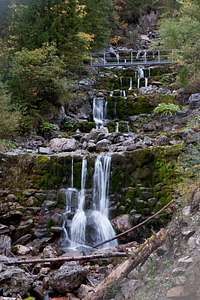 |  |  |
A metal bridge leads back to the northern side and here one of the tallest cascades tumbles down. The path avoids it to the left, then steadily rises towards the next step in the terrain. Gradually the path leads out of the Tobel and where it does you immediately hit the road to Seealpe. It gets almost level, crossing the meadows and pastures of the former Alpe, leading to the first station of the Nebelhornbahn cable-car.
Shortly before you reach the cable-car, a path leads through the valley, which has become rather wide here, heading directly towards the south slopes of Gaisalphorn. It heads up the slope for a few metres before turning west and running through a small creek bed (valley). The path is very eroded in this place and requires a bit of a detour to get to the other side. It then steadily rises across the pastures and through the trees leading in a wide curve towards Rossbichl (1466m), a small hillock in the flanks of Rubihorn.
 |  |  |
From Rossbichl the route gets steeper and leads in a direct line towards the saddle between Gaisalphorn and Rubihorn, which it reaches above 1800m. It gets more and more rocky and only patches of dwarf pines (Latschen) grow up here. On the ridge turn left (north) for the summit of Rubihorn. The path switches sides and heads up and down, avoiding the rockier sections or small gendarmes. In a small saddle the Gaisalpe Route joins from the east and about a hundred metres separate you from the summit.
 |  |