
-
 5417 Hits
-
 74.92% Score
-
 5 Votes
|
|
Route |
|---|---|
|
|
47.42350°N / 10.31496°E |
|
|
Hiking |
|
|
Summer, Fall |
|
|
Half a day |
|
|
Hike and scramble |
|
|
Overview
 Rubihorn seen from Unterer Gaisalpsee Rubihorn seen from Unterer Gaisalpsee |
The hiking route across Gaisalpe (sometimes Geißalpe) is probably the most popular tour Rubihorn. There are no difficulties except for moderate exposure near the summit and there are several points along the way which offer good resting possibilities. There is a small gorge, Gaisalptobel, which cuts short the tedious maintenance road and which offers some good scrambling along wet rocks. However, the Tobel trail can be closed depending on weather conditions. In 2006 huge downpours caused landslides in the narrow gully.
Most of the hikers either turn around at Gaisalpe at around 1450m, after having refreshed themselves at the restaurant up there. Another popular destination along the way is Unterer Gaisalpsee, where the hiking trails to Nebelhorn and Rubihorn split. The former heads across Oberer Gaisalpsee to the challenging Nebelhorn west ridge, while the Rubihorn ascent follows a wide cirque almost directly to the Rubihorn summit.
The character of the route is an easy hike up to Unterer Gaisalpsee and a bit of a scramble to the Rubihorn summit.
Getting There
Follow the instructions on the main page. The trailhead is at Reichenbach. There is a parking lot to the south of the village. Be early!Route Description
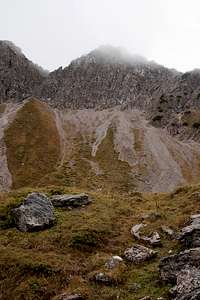
 Looking back through the ascent valley to Entschenkopf
- Start altitude: 867m
- Summit altitude: 1952m
- Prevailing exposure: E
- Type: 3-4h one way
- Protection: Few cables on the summit ridge
From Reichenbach a forest road leads in the direction of Gaisalpe. After several switchbacks, the Tobelweg through the Gaisalptobel gorge turns off to the left. If it is open (depending on the weather and the current conditions of rock- and treefall) rather follow the Tobelweg, which leads you into a dark narrow valley, overshadowed by old trees. The trail is rather slippery in several places, especially at the back of the gorge where it steeply ascends towards Gaisalpe itself. If the Tobelweg is closed (or in unsure lighting conditions) follow the support road to Gaisalpe.
At Gaisalpe one third of the crowd will stay to have a coffee while you can head onwards through the valley in the direction of Unterer Gaisalpsee. The lake is invisible at first because it is located above a huge step in the valley. The trail crosses several creek beds, where going on the polished rocks can be very slippery. Up at the lake the next third of the crowd will remain for picnics along its shore.
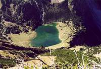 |  |  |
Stay on the eastern shore of the lake. Here a sign will point to Rubihorn, leaving the main trail, which heads on to Gaisalpsattel, Nebelhorn and Entschenkopf. Our route, however, follows the shore of the lake, then climbs up into the broad couloir / valley which heads up to the saddle which separates Rubihorn from Gaisalphorn. At first, while steep, the route remains rather easy. Several terrain steps have to be ascended before the valley ends right underneath the Rubihorn south ridge.
Herethe path has to negotiate the steep and brittle slopes underneath the ridge, which it does by numerous switchbacks. Erosion has either carved out the path or taken it away so that the ascent turns into a strenuous scramble. The most difficult sections are about halfway up but also the last switchback before the top is tricky.
 |  |  |  |
Finally the route heads out onto the south ridge of Rubihorn, where it is joined by the route from Oberstdorf. In steady up and down follow the ridge, negotiating the rock gendarmes and dwarf pines. The summit cross is located somewhat north of the real summit.