San Sevaine Lookout, San Gabriel Mountains

San Sevaine Lookout, San Gabriel Mountains

Page Type Page Type: Trip Report
Location Lat/Lon: 34.21730°N / 117.4902°W
Date Date Climbed/Hiked: Dec 24, 2007
Activities Activities: Hiking
Seasons Season: Winter

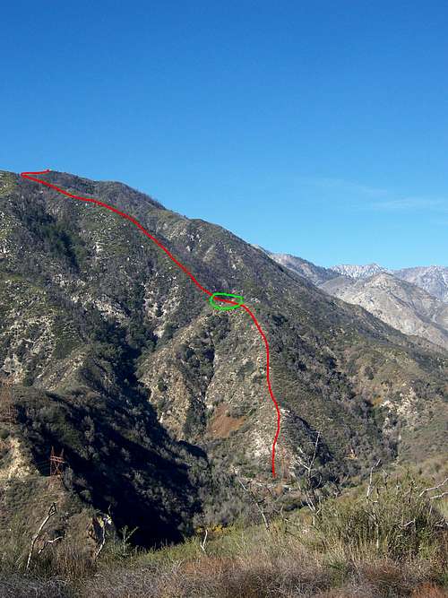
San Sevaine Lookout, Northeast ridge

San Sevaine Lookout is the eastern terminus of the +5000 foot elevation of the San Gabriel Mountains. San Sevaine is traditionally climbed from the San Sevaine Fire road. This route is 8 plus mile rough road drive up for a little 2.5 mile hike. In 2004 a fire blazed through the region and the road was closed by the San Bernardino National Forest. So access to this peak has been troublesome especially for the Hundred Peaks Section of the Sierra Club that has Sevaine listed. Personally I have wanted to hike this peak for a long time. In 2005 I had the opportunity to take part in a botanical collecting trip to nearby San Sevaine Flats. A beautiful area rich in cedars and black oak that escaped the fires. Though I was at the trailhead for the short hike to San Sevaine Lookout I did not have permission from work to go tramping off outside of our study area. The road is still closed and I have been looking for alternative routes other then hiking the long boring road. I decided on hiking the northeast ridgeline from the Lytle Creek. On topo there is a firebreak that descends the upper portion of that ridge, so I was hoping to hike from the bottom through brush and join up with the firebreak. The stats on the route look to be 2600 feet of gain with 4 miles round trip.
San Sevaine Lookout

The Hike

San Sevaine

I had hopes that the notorious brush of the northeastern San Gabriels might still be open from the 2004 fires. From the get go the hike was a steep brush feast. First I had to cross the very low Lytle Creek and ascend a class 2 brushy slope. Some brush is better then others. This region though is made up mostly of Whitethorn, ceanothus. I gained the first ridge and dove deep into the whitethorn intermixed with jagged chemise stumps. I gained the next ridge and was already feeling my saturation point with thousands of pinpricks all over my body. For a short respite the ridge opened with small yerba and was quick to gain the top of the ridge to the base of the firebreak.
San Sevaine Lookout

The Failure

At the saddle for the firebreak was a dense sea of 4 foot high Whitethorn, perfect groin height. And that firebreak on the topo, well that doesn't exist so much anymore. I took stock of the situation and continued for another couple or so hundred feet cussing and bashing at plants as my flesh was repeatedly torn. Once again I had reached a breaking point in this region of my home range. I sat down, brush the ticks and thorns off my legs, I made it about halfway up and decided to return home. Pissed off again for being turned around because of WHITETHORN! The return was eventful as I tripped over and over again, into sharp sticks and crumbling rocks faces. Finally made it down.
San Sevaine Lookout

Penstock Ridge 3080 feet

I sat in my car and drank some fluids and looked at my topo. Opposite of San Sevaine is a ridge named Penstock Ridge. It looked nice from Sevaine so I decided to hike up it's well maintained fire road. The route is three miles roundtrip with 700 feet of gain. The ridge had nice views of the Lytle Creek region and provided me with some great pictures of the northeast slope of San Sevaine.
Penstock Ridge

Next Time

Next time I will either start on the Rancho Cucamonga side or just mountain bike the San Sevaine fire road. I really want this peak now more then before. I love old lookout sites. Oh well, its Christmas Eve and I have family and friends to get drunk with.
Penstock Ridge


Comments

Post a Comment
Viewing: 1-11 of 11
theronmoon

theronmoon - Dec 24, 2007 8:33 pm - Hasn't voted

Re: Oh Yes

You bastard! You made it. I have been looking at the Bonita route for awhile too, especially for Buck. All I can say is I'm jealous, good work!

theronmoon

theronmoon - Dec 24, 2007 8:37 pm - Hasn't voted

Re: Oh Yes

Great pictures too!

theronmoon

theronmoon - Dec 24, 2007 10:55 pm - Hasn't voted

Re: Oh Yes

Ha, I just pulled a bloody thorn out of my arm at Christmas dinner. I would only do that ridge again if it burned, which I'm sure it will with all the arsonists around here.

theronmoon

theronmoon - Jan 3, 2008 8:19 pm - Hasn't voted

Re: Oh Yes

Today is 1-3-07 and my wife just pulled a 1/3 inch long thorn out of my shin 11 days after that hike. Didn't even feel it as she pulled it out. Now I have a even deeper respect for the eastern San Gabriels.

theronmoon

theronmoon - Dec 25, 2007 7:32 pm - Hasn't voted

Re: WTF

We'll I have a low slung corolla and I also have not climbed Sevaine. Sevaine, Buck, and Etiwanda are the only three I don't have in the east. I was actually planning on doing Rattlesnake that morning but i didn't get any sleep the night before. Merry Xmas man.

Travis_

Travis_ - Jan 1, 2008 11:57 am - Hasn't voted

Re: WTF

why not hike to San Servaine and Buck Point fron Icehouse Canyon over Etiwanda?

theronmoon

theronmoon - Jan 2, 2008 10:16 pm - Hasn't voted

Re: WTF

I have thought of that as a backpack. Maybe this summer. Hey congrats on 100!

Travis_

Travis_ - Jan 2, 2008 11:21 pm - Hasn't voted

Re: WTF

thanks, I am trying to decide if I should set a goal of another hundred for 2008....

Travis_

Travis_ - Jan 12, 2008 12:44 am - Hasn't voted

what about this route?

Here is the route I am now thinking, it was mentioned in the HPS route page from Buck Point. Trailhead from the north end of Etiwanda Ave. What do you think?

Topo Map - Route from Etiwanda Ave

theronmoon

theronmoon - Jan 13, 2008 10:02 am - Hasn't voted

Re: what about this route?

Yes, I have been looking at that route and a couple others on the south slope. From a distance it appears to be less brushy. I haven't been up close enough in awhile to really tell though. Your ridge is a goo middle point between Buck and Sevaine. You should give it a try.

Travis_

Travis_ - Jan 13, 2008 10:42 am - Hasn't voted

Re: what about this route?

I think I will try it out, here is the route in Google Earth, it looks like the firebreak is still there and it is fairly brush free.

GPS Tracks and more info I put together, including elev. profile

Viewing: 1-11 of 11

Parents 

Parents

Parents refers to a larger category under which an object falls. For example, theAconcagua mountain page has the 'Aconcagua Group' and the 'Seven Summits' asparents and is a parent itself to many routes, photos, and Trip Reports.

 
Penstock RidgeTrip Reports