Deciding what to do...
The last weekend in September was very busy for me, and I could not decide where to go and what to do. There was a forteener.org meeting in the Wetterhorn basin, and there was an American Alpine Club meeting at Indian Creek, and then I got a message from my friend
Chris to climb a
Lizard Head, and I suddenly knew what to do. Lizard Head was on my mind for a long time.
And since Chris was driving all the way from Santa Fe, we decided to warm up Saturday on some fourteener. Our original plan was to traverse El Diente to Mt. Wilson, but snowy conditions and our equipment changed our minds, so we traversed El Diente - ascended via northern = snowy slopes, and descended via southern = sunny slopes.
Morning hike to Navajo Lake
We met late Friday night at Navajo trailhead, and slept in our cars. The hike to Navajo lake was uneventful. I tried to keep a pace with long legged Chris, who was always a few hundred feet ahead of me. We took a small break at the Navajo lake - see the photo, and realized that I was smart enough to bring two ice axes on this hike. The northern slopes of El Diente were covered with snow. I had light hiking boots, and Chris only approach shoes. Oh well, we will see how far we get.
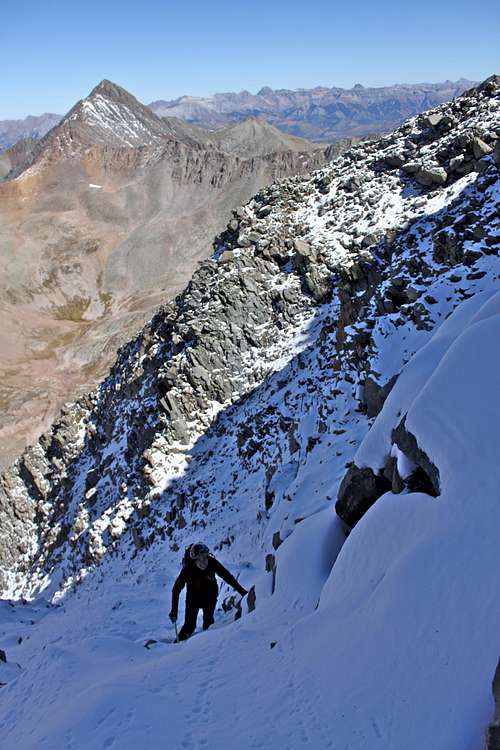
Snow scramble up the northern slopes
We slowly climbed up in the deep snow to the ridge, it was frozen snow, and we had to cut in footsteps at places. Neither of us complained, but I am sure that Chris had to have very wet socks. I could feel the cold elements on my toes, and my light hiking boots were better than his approach shoes. The climb was fun, but pretty steep for regular shoes. Would feel much easier with crampons. I enjoyed this section, not thinking, just moving up...
The ridge
Finally, we reached the sunny ridge between El Diente and Mt. Wilson at 13,900 feet. It was so nice to be in the sun. The route towards El Diente continues on the southern slopes initially, and later on you supposed to go back on the northern side to reach the summit. We lost our way when going back to the northern side - too much snow, no cairns visible. We could not see where was a rock in the snow, or where was just blown snow and a hole under it. So, we climbed pretty much on the top of the ridge or on the southern side.
The Summit 14,159 feet = 4316 meters
We rested on the summit for nearly an hour. The summit log was new (from September 2010), but the register was missing its top. Chris tried to search for it, but there was too much snow below. The view on the top was magnificent. We discussed what to do. Neither of us wanted to go descent Mt. Wilson in the snow. It felt so great to sit in the sun, so we changed out plans. We decided to descent via southern slopes and cross down to Kilpacker basin. And since we were not expecting this route, we had no information about it. I knew that there is some route, but where?
Southern Slopes
We took the first gully going down on the southern slopes of El Diente. This gully shortly changed into some overhanging mess, so we crossed further east to descent a few feet, and oops - there was again some overhanging mess. Some sections were pretty exposed and tricky, but route finding is fun... Finally, we saw a cairn. We were nearly 2,000 feet below the summit, and we hit the southern slopes trail. What a relief! We were safe.
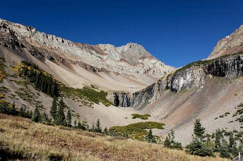
Kilpacker Basin
There was initially a nice trail on the southern slopes, then we lost it, and were zig zagging around meadows and forests until we finally reached the Kilpacker trail, which connects with Navajo Lake trail, and from where we knew how to reach our cars. Yes, we were a little bit lost, but knew our general direction. The Kilpacker Basin is very beautiful, no people, we saw elk, and I hope that hunters will not make it up there. The waterfall was spectacular (I took at least 50 photos, don't worry, will not post those).
Good night El Diente
Our trip was about 17 miles long, over 12 hrs out, and we had tons of fun. What a warm up for the signature of this weekend - Lizard Head. I could not wait for Sunday's excitement to come (TR to follow).
Requiem
A sad accident happened on Sunday (the day after our climb), thank you
Senad for e-mail me about it.
Telluride news


Comments
Post a Comment