Introduction
For the second weekend in a row we headed to the San Juan’s, looking to add two more notches to our 14er belts…well, just one for me. Mt Sneffels and El Diente Peak were on the docket and we planned to do an exciting class 3 scramble on each, hopefully as confidence boosters for our upcoming trip to Pyramid. Mt Sneffels would be first on Saturday and a repeat summit for me, but via an alternate route, followed by El Diente on Sunday. Sheri Vernier would join us for the Sneffels hike and offered us a good night sleep in the pop-up Chateau Vernier. We couldn’t turn that down and eagerly met Sheri, her husband Tim, their son Jake, and dog Kuma a few miles up Canyon Creek road outside of Ouray after the long drive down from Colorado Springs on Friday evening.
Return to Mt Sneffels
Saturday, August 11, 2007
Mt Sneffels (14,150’) – CO Rank 27
Route: Southwest Ridge (Class 3)
Total Distance: ~6 miles
Elevation Gain: 3100 ft
All Sneffels Pictures
Karen had been gracious enough to repeat five 14ers that were new to me earlier this summer, so the least I could do is repeat the only peak I’d done but she hadn’t. Fortunately, Mt Sneffels is my favorite 14er, and we were taking an alternate route at that, so I was pumped to go. We left the Chateau shortly after 5:30am and headed up the shelf road into Yankee Boy Basin, stopping just shy of 11,150-ft so Karen could hike the required 3000’ vertical gain to count the summit. We set off up the 4wd road on foot at 6:08am and made quick progress to a switchback near 11,200-ft where the trail branches off from the road. I remembered this spot well as this was exactly where I had parked my Jeep nearly 5 years ago when a group of friends and I thru-hiked the mountain from Blue Lakes - still my most spectacular trip to date, hands down. I would be filled with memories of that trip for the rest of the day. The trail traversed around and up through the basin on the way to Wright Lake where we first spotted our objective for the day.
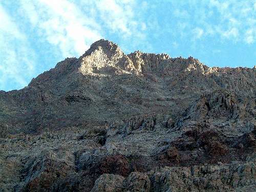
![Mt Sneffels]() Mt Sneffels
Mt Sneffels
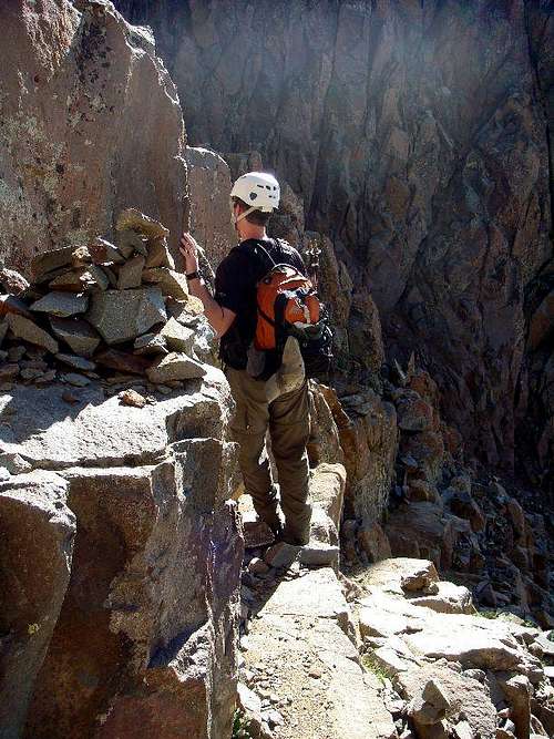
We stopped to take a few pictures and then continued on around the lake back onto the trail further up into the basin. Not too far past the lake we came to a junction between the Blue Lakes Pass trail and the standard trail up to Lavender Col. Sheri wanted to take the standard route to the summit so we wished her luck as she headed for the steep scree up to the col and we continued on up to Blue Lakes Pass, which we reached around 7:30am. At the top of the pass we ran into a hiker from New Mexico named John, who had come up from the Blue Lakes side and was planning to do the southwest ridge as well. The first bit of the route was the only segment that I was unsure of as I had seen many pictures of the area and read several trip reports but I never could quite figure out what features ahead of me I should be aiming for - I just knew that we should be following a cairned route or footpath and then pass through a notch.
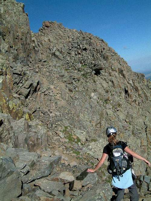
![Mt Sneffels]() We ended up scrambling between the two highest points just left of center
We ended up scrambling between the two highest points just left of center
Well, as we headed up I quickly discovered that I was in good company as the cairns eluded us and there were footpaths all over. And sure enough it seemed like every 100 feet there was a notch to my right leading around to the ridge. After gaining a few hundred feet above the pass we spotted what looked like a cairn further up underneath the large tower on the right that we had seen from the summit. Karen went up to check it out while I checked out yet another notch and sure enough, she had found the path. At this point, John had made his way up to us and we would continue the climb with him the rest of the way to the summit. We made our way up further past the tower via a short gulley on its left. In retrospect, when starting from Blue Lakes Pass, your target is right between the two most distinguished towers straight ahead. I wish I had taken better notes after that point, but the route was fairly obvious beyond that point as we climbed up through a series of short and often very loose gullies.
![Mt Sneffels]() Traversing around to another gulley
Traversing around to another gulley
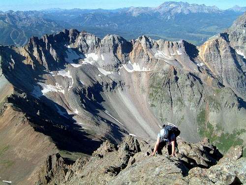
Not having done a class 4 route yet I couldn’t tell you if we pulled any class 4 moves or not, but we definitely managed some more difficult class 3 moves along the way. Once we gained the summit ridge, the fun began. John followed the ridge proper the whole way to the summit while Karen and I dropped below on the east side for a while.
![Mt Sneffels]() Karen traversing below the ridge
Karen traversing below the ridge
The further we got away from the ridge, the more loose the terrain became so we gradually made our way back up to where we could enjoy some moderate exposure to our west and dramatic views of Blue Lakes and points west on the Dallas Divide.
![Mt Sneffels]() Karen scrambling along the ridge proper with dramatic views behind
Karen scrambling along the ridge proper with dramatic views behind
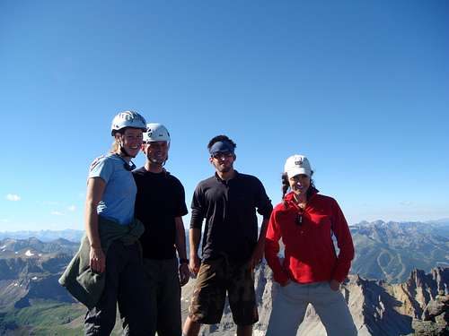
We slowed quite a bit along the way to take pictures but all of a sudden, the summit appeared and we topped out at 9:08am. Sheri beat us by about 20 minutes and was there waiting for us to celebrate her 30th 14er…congrats Sheri!. An early summit meant that the weather was still terrific, so we ended up spending nearly an hour taking in the dramatic views from up top and naming the surrounding peaks with others on the summit.
![Mt Sneffels]() Karen, Jim, John, and Sheri on the summit!
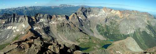
Karen, Jim, John, and Sheri on the summit!![Mt Sneffels]() The view southwest from the summit
The view southwest from the summit
When we had our fill of pictures we started the descent down the standard route. The v-notch leading back into the gulley that lead up from Lavender Col wasn’t as exposed as I remembered it being 5 years ago, but I figured my 28 summits between now and then had adjusted my perspective. Entering the top of the gulley we looked down to a virtual interstate of hikers headed up. There was still some snow along climber’s right that most were bypassing by staying on loose junk on climber’s left, but the sun had softened the snow enough for us to make quick progress plunge-stepping down past them. We stopped for a few more pictures after reaching the col before heading down further.
![Mt Sneffels]() Karen posing in front of Gilpin Peak
Karen posing in front of Gilpin Peak![Dallas Peak]() Awesome centennial Dallas Peak
Awesome centennial Dallas Peak
The remaining ~900-ft back to the basin was as slippery as I remembered previously as we shoe-skied our way down the loose scree. Once back in the basin the remainder of the hike was fairly uneventful as we chose the trail that linked back to the top of the 4wd road and made our way back to the car just after noon before heading down into Ouray for lunch and a soak in the Ouray Hot Springs.
El Diente Peak
Sunday, August 12, 2007
El Diente Peak (14,159’) – CO Rank *
Route: South Slopes (Class 3)
Total Distance: ~12 miles
Elevation Gain: 4100 ft
All El Diente Pictures
The drive from Ouray over to the Kilpacker trailhead turned out to be much further than I had expected but we pulled into the parking area surrounded by a large meadow shortly before dark. Still nice and relaxed from the hot springs we set up sleeping bags in the back of the Jeep and hit the hay. The weather forecast had looked as promising as could be for monsoon season in the San Juan’s, and with 12 miles facing us Sunday we set the alarms for 2:30am. Karen and I were both pretty nervous about the hike as we had heard plenty of horror stories about this one and I can’t recall reading any trip reports from people who actually enjoyed climbing El Diente. Fortunately our planned route from the Kilpacker side was supposed to be a little more stable and not quite as steep. The biggest question in my mind was “how would we do on the final ridge traverse?” 2:30am came quickly and I struggled to want to get up after not sleeping well. We both fell asleep again but only for a few minutes. We quickly packed up and hit the trail at 3:08am. The first 4 miles were erie as we hiked under headlamps through the wide open meadows amongst tall grass and aspen trees. We both remembered reading a trip report from a hiker who had come across a mountain lion on this trail and that fear seemed overly real in our minds this morning. We came to the spur junction where the El Diente trail splits off to the right and actually noticed we were there almost by accident…this is an easy split to miss in the dark, and my GPS marked it at 2.25 miles (earlier than I had expected). We continued on and across Kilpacker Creek still having gained practically no elevation 3.5 miles into our hike. We were making good progress, but the further we went with out going up was making me realize the steep slopes we would be facing ahead. We made a couple of wrong turns close to Lower Kilpacker Falls, turning right at a split (instead of left) and heading into some campsites. Fortunately we had printed out a route description and quickly corrected our mistake. Shortly thereafter however we screwed up again and started heading up a ditch that sure looked like it could have been a trail at 5:00am. We stopped for a break to eat something and figure out where we had gone wrong and after backtracking down the ditch we found the trail again. The sun was making a lazy entrance that morning as we continued on up the trail reaching the infamous dinner-plate scree pile we had read so much about. After passing through a super steep section of willows we then started the long traverse under El Diente’s south face. By 7:00am the sun had revealed El Diente’s nasty looking south slopes and we had reached the end of the traverse.
![El Diente Peak]() El Diente's crumbly south face
El Diente's crumbly south face
One step at a time, we started the slog up to the summit ridge. The route was very well cairned and Karen did an excellent job spotting them on the way up. I was surprised to find the rock to be more stable than I expected, although we were moving extremely carefully. The lower segment of the ascent stayed mostly around class 2 or 2+ before we finally reached a class 3 section a few hundred feet below the ridge. This section reminded me very much of the ledgy gulley leading up to the summit of Wetterhorn we had climbed last weekend and we ascended it with ease.
![El Diente Peak]() Karen climbing a class 3 segment of the south slopes
Karen climbing a class 3 segment of the south slopes
Before we knew it we had made our way to a cairn just west of the Organ Pipes marking the start of the ridge traverse. I had printed off a series of excellent pictures from the North Slopes route description of this segment posted on 14ers.com and was thankful to have them as the route was not obvious for beginning route-finders like us. We made our way along the last ¼ mile to the summit slowly and carefully, pulling out the pictures a few times to double-check our next steps. I was pleased to find that the exposure wasn’t really that bad as long as we were on route. The only nervous areas were a couple of loose steps that skirted yawning chasms below.
![El Diente Peak]() The remainder of El Diente's summit ridge from the north side
The remainder of El Diente's summit ridge from the north side
We continued to make steady progress and soon enough found our way to the last loose gulley to the summit, finally topping out just after 9am, woohoo! I was so excited to have made it to the summit of this peak that I almost forgot to look around.
![El Diente Peak]() My 40th summit mug
My 40th summit mug
We hung out for a bit and chatted with two guys who had come over from Silver Pick basin and up the north slopes and then a female climber who had brought along her 3 dogs…wow! All mentioned how loose and crappy the North Slopes route had been, reaffirming our conclusion that Kilpacker is definitely the way to go! After a few more pictures and a snack we started the descent, which I’m pleased to say was fairly uneventful. We took our time again along the ridge, passing a group of 4 on their way up from the Kilpacker side, and then methodically back down the south slopes. I don’t remember feeling so excited to get back onto low-angle scree as I was once we got down into Kilpacker basin. Further down we were rewarded with spectacular views of Upper and Lower Kilpacker Falls and the south face of El Diente.
![El Diente Peak]() Departing views of challenging El Diente Peak
Departing views of challenging El Diente Peak
It felt good to get back on the more level terrain heading back to the trailhead and it was nice to enjoy the flowery meadows that eluded us earlier that morning. We picked up the pace just before reaching the car as thunderstorms were moving around the area and finished off the hike at 2:00pm. We felt blessed to have had such a great day to hike and were excited to have met the challenge offered up by El Diente.


Comments
Post a Comment