
|
|
Route |
|---|---|
|
|
47.10680°N / 11.16560°E |
|
|
Scramble |
|
|
Most of a day |
|
|
II |
|
|
Approach
Head from the Franz-Senn-Hütte towards the Horntaler Joch but keep below the last rocky parts (on the right of the trail). If you approach from Lüsens, go to the Horntaler Joch and get down on the south side below the rocky parts on the side.
From there climb the gras slope (which is easy though the trail is hardly detectable) until you either find the trail or reach the ridge. The part of the ridge you need to find is the col on the very left part of the signature picture (on the main page).
From there follow the trail which turns to the north side of the ridge.
Route Description
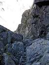
When the really rocky part begins, a (red marked) trail goes diagonal through the southeast face (Schiefer Gang). Occasionally one finds hooks for fixing a rope. Follow this "Schiefer Gang" about 70 m and follow the steep couloir upwards. Again one finds occasionally hooks and vanishing rests of a red colour. When the couloir is divided into two couloirs follow the left one (The forking is seen in the picture) until you reach the northwest ridge. Follow this ridge strictly towards the summit. Don't leave it towards east (even when you find it might be easier - it is not - but more slippery).
Ascent from OberIss: 4.5 h Descent 4 h.
 |  |  |
Essential Gear
It is possible to make this without climbing gear (I made it) though this is recommended only to climbers which are 100% perfect in climbing UIAA II (better III): Keep in mind that you have to go down with the same difficulty as well and consider the weather to get worse.
To make a long story short: Take a rope and a harness and some biners with you.
Miscellaneous Info
If you have information about this route that doesn't pertain to any of the other sections, please add it here.
haraldag - Sep 13, 2004 6:13 am - Hasn't voted
Route CommentI am not sure what is meant with "do not leave it towards east". At the point shown in the middle picture the ridge forks. The left arm (when viewing upwards) is broad whereas the right arm looks smaller. In the lower part both arms are relatively easy but as one approaches the top the right arm becomes very narrow and slippery. I'd advise to take the left arm.
JoPo - Sep 22, 2004 7:53 am - Hasn't voted
Route CommentPossibly the problems arose since my english, especially my "mountaineer" english is not good enough.
The middle picture shows a couloir (Rinne) that goes from the "Schiefer Gang" to the north ridge. Somewhat above the point where this picture was made, the couloir divides in two couloirs. One has to follow the *left* one. This is inncorrect in the original description I gave (I'll correct it soon). To keep left is an information taken from the Klier guide book. Obviously I recalled that incorrect.
Once you reach the ridge (Grat) through this left couloir you reach the summit by strictly keeping on the ridge. Do not leave the ridge towards west into the steep slope (Steilhang) though it might look easy on a first glimpse. The slope is very slippery and crumbly (bröselig). I tried it and I was lucky to come back without accident. When you keep on the ridge you have to scrample over rocks but much easier than, e.g. the couloir before.
Hope these additions and the correction help.
I'll include them soon into the route description
haraldag - Dec 1, 2004 6:29 am - Hasn't voted
Route CommentYes, my "mountaineering english" is also far from perfect. I guess if we could discuss this in german it would be a lot easier. But for the sake of internationality...
My information stems from the "Alpenvereinsfuehrer Stubai". In the description it mentions two forkings in/after the "Schiefen Gang". In the first one you should go right, in the second one (the one shown on your picture above) you should go left. Since we did not realize passing the first forking we accidentially took the couloir to our right in the second forking (which we considered to be the first one). Well, we made it to the top, but I would urgently advise not to follow this route.
I have some photos of this tour on my homepage, unfortunately it is offline for some days now.
JoPo - Dec 1, 2004 10:32 am - Hasn't voted
Route CommentI corrected it finally. Everything Harald wrote is correct. Thank you again.