
|
|
Route |
|---|---|
|
|
43.12330°N / 19.03690°E |
|
|
Marked Path, Hike, some easy Rock Climbing |
|
|
Most of a day |
|
|
Hike with some easy rock climbing |
|
|
About Route
Sedlo (1907m) is highest road pass in Monte Negro. It is crossed by Zabljak – Trsa road, which is mostly macadam. It is placed between Sedlena Greda (2227m), on the south, and Uvita Greda (2199m), on the north, 12km from Zabljak. Of those 12 last 3km are macadam, which is currently quite bad, but passable for all cars if you drive slowly. You can also get here by taxi from Zabljak if you are descending back to Zabljak from the summit. That would cost you 20€.To reach Sedlo pass head from center of Zabljak towards Savnik (south). Road goes over undulating grassy Jezerska Povrs plateau. After 5km table by the road will show you that Trsa is right. Over the plateau road heads towards Sljeme and Savin Kuk who show their soft green slopes from this side. Along the plateau many small houses are scattered, view is fantastic. Then road turns left and winds up gradually, over the open grassy slopes, through Virak village and rare beech groves behind it. Left below the road is Poscensko Jezero (1487m) lake. After few kilometers, below beautiful steep and sharp cone of Stozina (1905m), asphalt ends and macadam enters upper part of Poscenska Dolina valley. Left is beautiful rocky Ranisava (2081m) and sharp green Sedlena Greda (2227m). In front of, right of Sedlo pass, is also green and sharp Uvita Greda (2199m). Right above the road are high and green slopes of Sljeme (2455m). After 3km of macadam and two sharp serpentines road reaches Sedlo pass.
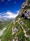
Route from Sedlo pass is equally popular as Zabljak (northern) approach. It offers completely different picture of Durmitor, southern side is completely treeless and mostly under juicy grass, which is unbelievably green, almost fluorescent. Its carpet in mixed with countless flowers of all colors. In contrast with deep blue sky, white limestone rocks and cliffs and snow remains, southern green side is photo paradise. Once you approach foot of Bobotov Kuk rock takes over and you are in fantastic amphitheater of cliffs, closed by some of the highest Durmitor peaks, including ‘the boss’ Bobotov Kuk, himself. But before that you’ll be greeted by 14 picturesque teeth and cross once glaciated and now green plateaus.
This route is also easier than Zabljak route because it begins 500m higher and distance is shorter which results with 2h less to the summit. It is best to cross Durmitor as a daily trip. Which route to use for ascent and which for descent is hard to tell, it is matter of personal taste. Easier combination is to use Sedlo route to ascent and Zabljak route to descent.
Sedlo pass – Surutka – Zeleni Vir – Bobotov Kuk: 3h
Route can be divided in two sections, up to Zeleni Vir lake and to the summit, because three routes meet at Zeleni Vir, including the other southern approach from Dobri Do.
Section 1) Sedlo pass – Surutka – Zeleni Vir
Section 2) Zeleni Vir – Velika Privija – Bobotov Kuk
Section 1) Sedlo pass – Surutka – Zeleni Vir: 1.30h
On the pass orientation red table points you towards north. After short (5mins) but steep climb path takes you to grassy plateau that spreads below the barrier in front. Getting over the barrier is first task of the day. Path aims towards the pass (2140m) between Vjetrna Brda (2231m) on the left and Uvita Greda (2199m) on the right. Over the green plateau that is decorated by white limestone boulders path leads you towards the foot of SW cliffs of Uvita Greda. Once below them it turns left and traverses scree slopes. Before turning right, straight up into the couloir below the pass, path uses nice narrow shelf. From here beautiful views spread towards SW and green waves of Dobri Do basin below. Final climb to the pass is steep and leads over the scree and grass. Once there, 30mins from Sedlo, beautiful view of southern faces of Bandijerna (2409m) and Milosev Tok (2426m) opens in front of you.Behind the passage path traverses eastern grassy slopes of Vjetrna Brda, gradually ascending. Shortly you are on the shoulder from where fantastic string of 14 sharp teeth completely opens. They are Zupci (2309m) and will accompany you for the rest of the way to the summit of Bobotov Kuk which towers behind them. After another 15mins you are on the green pass called Suvi Tavani, at the edge of Surutka, former glacier basin below picturesque Zupci, which close the basin from the north. Left are green waves of Vjetrna Brda.
From the pass path gradually descends 15mins to the bottom of Surutka (2082m). Along the descend snow remains till August. At the bottom of Surutka there is usually a pond and bit above it, along the path, small source, which can run dry out.
From the pond in Surutka path begins to ascend again, this time till grassy shoulder in the western foot of Zupci. It is on 2140m and you reach it in 10mins during which you surmounted 60m of altitude. View which opens from this spot is nothing short of amazing! In front, over the Mlijecni Do basin, is Stit (2248m) peak with its fantastic twisted layers of white limestone and green shelves. These layers that look like waves are called Zeleni Pasovi or green layers. Right of them is narrow Samar (2075m) pass which divides Stit from mighty cliffs of Djevojka (2440m). Behind Samar upper part of bulky green Prutas (2393m) sticks. Right of Djevojka is summit triangle cliff of Bobotov Kuk (2522m). Right of Bobotov Kuk is Lucin Vrh (2396m). They are separated by Velika Privija pass (2351m), which is where path will lead you, but first you have to descent to Zeleni Vir (2028m) lake which lies at the bottom of this beautiful amphitheater that is further towards right closed by the cliffs of Minin Bogaz (2387m) and back (north) side of Zupci (2309m). Rest and enjoyment in this fantastic panorama is a must, at least for few minutes.
From the shoulder path descends 15mins over the grass, scree and huge boulders till the shore of Zeleni Vir lake. It is highest placed lake on Durmitor and its cold water is great refreshment before the coming climb. Zeleni Vir is up to 2.5m deep but can dry out in some very dry summers. On the northern shore, between the rocks just above the lake, is also water source. Till here you need 1.30h from Sedlo pass.
From the lake path heads towards left (west) and very soon reaches the junction where from left Dobri Do route approaches while straight path heads towards Samar pass & Skrka valley.
 |
Section 2) Zeleni Vir – Velika Privija – Bobotov Kuk: 1.30h
On the junction you are at the foot of Cista Lica (clear face), 320m high barrier below Velika Privija pass (2351m) and 500m below the summit. Barrier is placed between steep and high cliffs of Djevojka (2440m) on the left and Lucin Vrh (2396m) on the right. On top of it is Bobotov Kuk (2522m) and pass.Over the steep scree path soon reaches the barrier and surmounts the first steep step through narrow gully. Above it path continues steep ascent over the rock till next steep step. Again it is surmounted through a gully. On top of it steepest part of the climb to the pass is below you. Views spread with every step and are already fantastic towards south. Above is steep scree or grassy slope with occasional steeper rocky jumps. Path zigzags relentlessly. After a while you reach large green grassy slope that stretches all the way to the pass. Over it, in numerous zigzags, after 1h of steep ascending from the Zeleni Vir lake, you’ll reach Velika Privija pass (2351m). From it beautiful view opens upon the huge Valoviti Do basin, which is strewn with huge boulders and snow remain, and quite different northern side of Durmitor. Further behind is green Jezerska Povrs plateau and the canyon of Tara river. It takes 2.30h from Sedlo pass to get here. On the pass is junction where from north Zabljak route approaches. If you are crossing Durmitor you’ll use it on the descent but first Bobotov Kuk is on the menu and it is left.
Path ascends over the scree along the southern foot of summit pyramid of Bobotov Kuk. Its summit is not visible. After 10mins probably most spectacular view one can find on Durmitor opens in front of you! You are on the narrow pass between Djevojka (2440m) on the left and Bobotov Kuk (2522m) on the right, at the edge of huge face formed by the western faces of these peaks. Their verticals are lost in the depths deep below your feet, below them are immense scree slopes and amazing green Skrka valley with its two beautiful blue lakes and mighty but gentle green Prutas (2393m) peak left of the lakes. Mountaineers named the pass Skrcki Pogled or the view of Skrka. Don’t worry, even when one knows how fantastic view opens from this spot surprise is still complete.
From the small pass path continues horizontally for a minute or two, using narrow grassy shelf in the western face of Bobotov Kuk. This is magnificent section, on the left is nothing but 700m of air above Skrka valley Then it turns right and ascends steeply over the rock, use of hands is necessary. Then again goes right using narrow shelf. Once on the southern shoulder of the peak marks turn sharply left and soon you are on the summit of highest peak of Durmitor, 15min from the Skrcki Pogled pass, 1.30h from Zeleni Vir lake, 3h from Sedlo pass.