
|
|
Route |
|---|---|
|
|
46.45436°N / 11.64851°E |
|
|
Hiking, Scrambling, Via Ferrata |
|
|
Summer |
|
|
Half a day |
|
|
EEA - pp I UIAA |
|
|
Overview
 Magnificent view (Vajolet towers) during the climb
Sentiero attrezzato Bepo de Medìl is a wonderful path, partially equipped with iron cables, leading to a fascinating and solitary peak in the heart of Larséc group.
The path reaches the Anfiteatro (amphitheater) on the south-west of the summit, then the west ridge, passing through a rocky gully assured with iron cables.
The trail was signed and equipped in the 30ies by the Gardeccia Hut's manager of that time Giuseppe Desilvestro, nicknamed Bepo de Medìl. In the following decades, the landslides, the ice and the snow damaged the trails and destroyed the iron cables, and the path was forgotten by hikers and alpinists.
Recently, the path was restored and the iron cables replaced: now, the Sentiero Bepo de Medìl is an interesting route, climbing through a wild environment with severe hiking difficulties. When I hiked this path, in august 2009, I didn't meet anyone, but only traces of chamoises and mouflons, while in the range of few miles hundreds of hikers and climbers crowded the surrounding mountains...
DIFFICULTIES: EEA, pp I UIAA.
It's an hike for many, but not for everyone: it is adviced for experienced hikers, not fearing to scramble and walk on friable rocks and scree. Even if the route is completely marked with cairns and paint, it requires, anyhow, attention to not get lost. There aren't true technical difficulties, but a severe, “not tamed” environment: good mountain experience and firm step are required!
In early season, usually until the end of july, the narrow gully in the middle of the route, assured with iron cables, is filled of iced snow: in that case the climb become more demanding and crampons and ice-axe are required.
BEST SEASON TO CLIMB: summer. Until the end of july ice-axe and crampons could be necessary to climb a narrow gully filled of iced snow.
Getting There
 Click to enlarge the map
The point of departure is Gardeccia Hut.
You can easily reach it from Pera di Fassa, with a taxi service starting from the parking of the chair lift "Vajolet". Click to download the timetables (PDF format)
As alternative, from Pera di Fassa you can take the 3 chair lifts leading to Ciampedìe (Vajolet1, Vajolet2, Ciampedìe) and, from there, in about 45' (trail 540) to Gardeccia Hut.
Ciampedìe is also reacheable with a cablecar from Vigo di Fassa.
You can reach Vigo and Pera di Fassa by car:
- From North: taking A22 motorway until "Bolzano Nord" exit. From there, follow the route SS241 "Grande Strada delle Dolomiti" via Passo Costalunga - Vigo di Fassa (distance 37km to Vigo, 40Km to Pera)
- From South: taking A22 motorway until "Ora/Egna" exit. From there, follow the route SS48 delle Dolomiti via Passo San Lugano - Val di Fiemme - Val di Fassa (distance 52km to Vigo, 55 to Pera).
You can reach Vigo and Pera di Fassa by bus:
- From Bolzano/Bozen: click here to see timetable of bus service SAD
- From Ora/Auer: click here to see timetable of bus service SAD
- From Trento: click here to see timetable of bus service Trentino Trasporti
Closest railway station: Bolzano/Bozen, Ora/Auer, Trento. See the Ferrovie dello Stato website for informations and timetables.
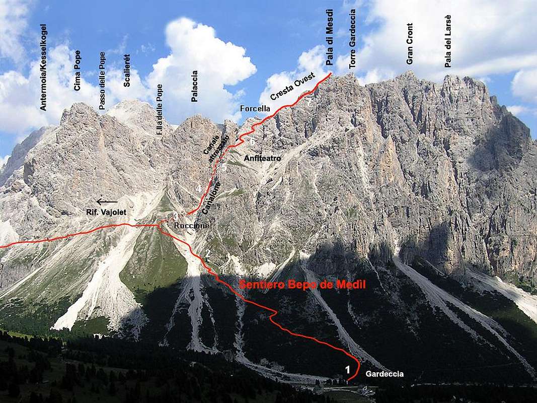
In case you spend the night at Vajolet or Preuss huts, you can reach directly Sentiero Bepo de Medìl from these huts, without passing by Gardeccia: from Vajolet hut go in direction north (Passo Principe), but not on the wide trail leading to Passo Principe hut, but on a narrow path, crossing the Soial creek and rising the screes on the Cima Pope slopes; don't follow the trail to Pope pass, but the path leading on south (right), joining, after about 40min, Sentiero Bepo de Medìl near a big rock ("Roccione", nr 3 in this picture)
Route Description
From Gardeccia (1980m), cross the creek Soial (usually dry in summer) on the rear of the hut: on the other bank you can find a sign indicating “Sentiero attrezzato Bepo de Medìl”. The trail rises up in a scrub of mugo pine, then passes through the steep slopes descending from Pala di Mesdì; it crosses a landslide and, always on friable ground, reaches a big rock (45min from Gardeccia hut). This point is also reachable from the Vajolet and Preuss huts (40min, see the Getting there section).From there take the path on your right (the trail on the left leads to Vajolet hut) and traverse to the bottom of a wide and severe gully: now follow the cairns and the red paint marks, rising the steep and unstable ground, to the top part of the couloir, until you meet a red arrow painted on a rock: the path continues in a narrow gully on the right side, assured with iron cables. At the start of this narrower, side gully you can see the old iron cables, now destroyed by the time, placed there by Bepo de Medìl in the 1930. Further on, you can find the new ropes (quite good at august 2009): they aren't necessary in dry conditions, but this narrow gully is usually filled by snow until advanced summer and, in this case, it could be good make self-belay with a ferrata kit (and use ice axe and crampons!). Climb the narrow and steep gully, keeping attention to the friable ground, until you reach a vertical rocky step where an iron peg helps the not so easy passage. After this quite demanding stretch of the route, the path exits on the so called Anfiteatro (amphitheater): in front of you, you can see Pala di Mesdì summit and its west ridge, while at the bottom-right is visible Gardeccia hut. Follow the cairns and the red paint marks rising up on the left, passing on easy rocks and gravels. The trail traverses the slopes (a tricky passage) and reaches the west ridge at a little saddle, where joins the normal route path. Walk up the beautiful and panoramic ridge, passing a short but quite demanding passage (I UIAA), and reach the summit marked by a big cairn and an old cross of wood, raised by the priest-climber Don Tita Soraruf in the period between the two world war (2h 30min from Gardeccia, about the same time if you start from Vajolet hut)
Descent
For the descent, go back to the little saddle on the west ridge and follow the Normal route from Conca del Larséc (see the Routes section in the Pala di Mesdì main page)
 |
|---|
The numbers in the picture sign the places where the pictures below were taken
 1 1 |
 2 2 |
 3 3 |
 4 4 |
|---|---|---|---|
 4 4 |
 4 4 |
 5 5 |
 5 5 |
 6 6 |
 6 6 |
 6 6 |
 7 7 |
Essential Gear

Helmet: it’s necessary in the couloir, mainly in the narrow side gully where there are the iron cables.
Harness, Via ferrata kit: adviceable, but not obbligatory, for very expert hikers or alpinist in case of dry conditions (usually since august). In early season, in case of iced-snow, the steep gully could be very demanding and dangerous: the Via ferrata kit is necessary.
Ice axe, crampons: often necessary in early summer (until the end of july). Ask for info on the conditions to the Gardeccia hut manager.
Guides, Maps, Weather Forecasts
 View on Palaccia from the gully
Guides
- Antonio Bernard, La nuova guida del Catinaccio, Edizioni Mediterranee, 2008
- Luca Visentini, Gruppo del Catinaccio, Athesia, 1982, also in german language with the title "Rosengarten" (out of catalogue)
- Arturo Tanesini, Guida ai Monti d'Italia: Sassolungo, Catinaccio, Latemar, CAI-TCI 1953 (out of catalogue)
Maps
- Tabacco, foglio 06, Val di Fassa e Dolomiti fassane, 1:25.000 (the best)
- Kompass, Rosengarten/Catinaccio Latemar, 1:25.000
- LagirAlpina, Carta Escursionistica-Mountainbike Val di Fassa, 1:25.000
Weather forecast