
|
|
Mountain/Rock |
|---|---|
|
|
46.45436°N / 11.64851°E |
|
|
Hiking, Mountaineering, Via Ferrata |
|
|
Summer |
|
|
9049 ft / 2758 m |
|
|
Overview
 The last meters to the summit
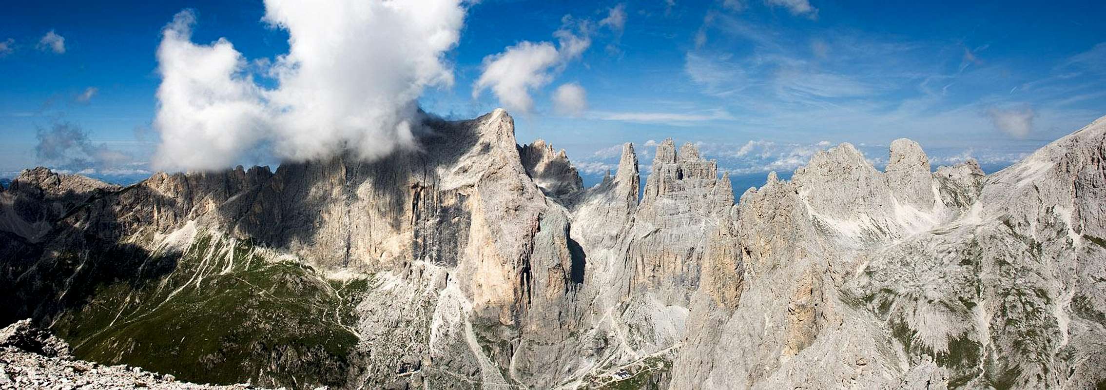
Pala di Mesdì is a lonely and panoramic summit placed in the Larséc Group. It belongs, with other rugged and sharpen peaks, to the so called Dirupi di Larséc (Crags of Larséc): this is the most important and famous part of the Larséc group, a fascinating castle rich in rocky towers.
This mountain presents an aerial and peaky top, with a short jagged ridge running from west (saddle splitting by Palaccia summit) to east (saddle splitting by Torre Gardeccia summit). It drops on west, over Gardeccia bowl, with an amphitheater of gravelly and rocky slopes, edges and gullies. On the east it goes down on Larséc valley with short rocky faces.
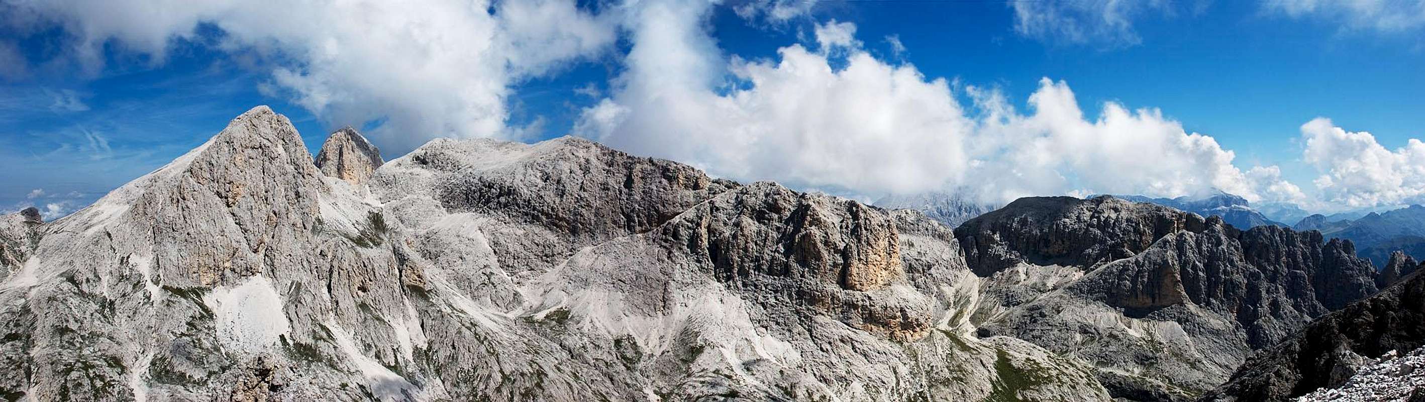
Despite its not so high elevation (2758m), from its isolated summit there's one of the best view of the whole Catinaccio range: in particular, the sight on Cima Catinaccio/Rosengartenspitze and Vajolet Towers are unusual and breathtaking, but also the panorama toward Mugoni-Coronelle-Cigolade, Antermoja/Kesselkogel and the rest of Larsèc are very beautiful and interesting.
This very nice summit, in spite of these attractives, is rarely climbed: most of the hikers prefer the more celebrated mountains or the athletic and acrobatic Via Ferratas, avoiding the wild trails and the crumbling rocks where chamoises are more frequent than mountaineers. All the better for the lovers of the "true" mountain: on Pala di Mesdì they can still find silence and wilderness, in the heart of the more celebrated Dolomites...
First time climbed by L. Bernard, H Stabeler, L. Darmstaedter the 7th of july 1887, from the south west gorge.
Getting There
 Click to enlarge the map
The best starting point to climb Pala di Mesdì is Gardeccia Hut.
You can easily reach Gardeccia Hut from Pera di Fassa, with a taxi service starting from the parking of the chair lift "Vajolet". Click to download the timetables (PDF format)
As alternative, from Pera di Fassa you can take the 3 chair lifts leading to Ciampedìe (Vajolet1, Vajolet2, Ciampedìe) and, from there, in about 45' (trail 540) to Gardeccia Hut.
Ciampedìe is also reacheable with a cablecar from Vigo di Fassa.
You can reach Vigo and Pera di Fassa by car:
- From North: taking A22 motorway until "Bolzano Nord" exit. From there, follow the route SS241 "Grande Strada delle Dolomiti" via Passo Costalunga - Val di Fassa (distance 37km to Vigo, 40Km to Pera)
- From South: taking A22 motorway until "Ora/Egna" exit. From there, follow the route SS48 delle Dolomiti via Passo San Lugano - Val di Fiemme - Val di Fassa (distance 52km to Vigo, 55Km to Pera).
You can reach Vigo and Pera di Fassa by bus:
- From Bolzano/Bozen: click here to see timetable of bus service SAD
- From Ora/Auer: click here to see timetable of bus service SAD
- From Trento: click here to see timetable of bus service Trentino Trasporti
Closest railway stations: Bolzano/Bozen, Ora/Auer, Trento. See the Ferrovie dello Stato website for informations and timetables.
Routes Overview
 Click to enlarge the topo of Normal route
- Normal route from Conca del Larséc:
From Conca del Larséc and the west ridge, diff: EE: you can reach Conca del Larséc (Larséc bowl) from Gardeccia (1950m), taking path 583 (Sentiero Attrezzato delle Scalette, EEA) to Passo delle Scalette (Scalette pass, 2359m, 1 h 30 min).
From there, proceed few minutes along the trail until the junction with the path for Passo delle Pope (Pope pass); follow this trail, crossing Conca del Larséc to its western border; when you meet on your left (west) a marked trail descending from a col on the Pala di Mesdì ridge, follow it; when you reach the small saddle take, on your left (south-east), the Sentiero Attrezzato Bepo de Medìl trail and climb the easy and panoramic west ridge to the summit (1 h 15 min from Passo delle Scalette, 2 h 45 min from gardeccia)
- From the west side, by Sentiero Attrezzato Bepo de Medìl
From Gardeccia through the west flank, Diff.: EEA , pp I UIAA, iced snow until early summer
In addition to these two, there are other two routes, nowadays disused (cfr. Antonio Bernard, La nuova guida del Catinaccio, ed. Mediterranee, 2008):
- Gola sud-ovest (South-west gorge): it's the route of the first climbers, I/II UIAA
- Via Versante sud (South side route): 160m, IV UIAA, poor rock
Red Tape
In all the area free camping is not allowed, except the alpinistic bivouac: you can pitch a tent just before sunset, and remove it at sunrise. Conca del Larséc is a nice place for a bivouac, but in late season (from late july to september) there's no water around.No fees and permits required.
 From Gardeccia (SW) From Gardeccia (SW) |
 From Gardeccia (SW) From Gardeccia (SW) |
|---|---|
 From Ciampedìe (S) From Ciampedìe (S) |
 From Cima del Larséc (N) From Cima del Larséc (N) |
When to climb
Usually from late June to early October. In early season (June and July) crampon and ice-axe are necessary in the narrow gully of Sentiero Bepo de Medìl, due to the iced snow usually present in that steep couloirPanorama from the summit
  |
 |
Guides, Maps, Weather forecast links
 View from Pala di Mesdì west ridge
Guides
- Antonio Bernard, La nuova guida del Catinaccio, Edizioni Mediterranee, 2008
- Luca Visentini, Gruppo del Catinaccio, Athesia, 1982, also in german language with the title "Rosengarten" (out of catalogue)
- Arturo Tanesini, Guida ai Monti d'Italia: Sassolungo, Catinaccio, Latemar, CAI-TCI 1953 (out of catalogue)
Maps
- Tabacco, foglio 06, Val di Fassa e Dolomiti fassane, 1:25.000 (the best)
- Kompass, Rosengarten/Catinaccio Latemar, 1:25.000
- LagirAlpina, Carta Escursionistica-Mountainbike Val di Fassa, 1:25.000
Weather forecast