
|
|
Route |
|---|---|
|
|
46.41703°N / 13.46306°E |
|
|
Hiking, Via Ferrata |
|
|
Summer, Fall |
|
|
Most of a day |
|
|
medium via ferrata |
|
|
Overview
 ledges
 map of the route
| route type | hike-via ferrata |
| max elevation | 2531 m |
| elevation gain | 1030 m from the Altopiano del Montasio |
| total length | around 12 km |
| Difficulty | medium via ferrata – very exposed passages on ledges |
| Time required | 8/9 hours |
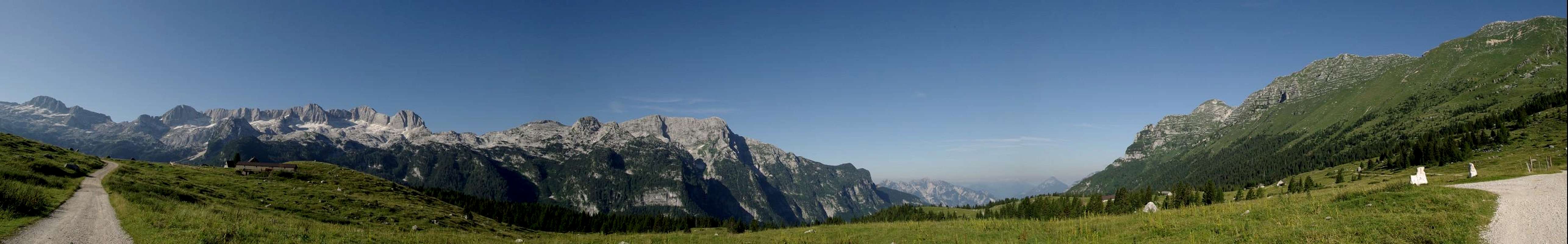
This wonderful route is definitely one of the best you can do in the Julian Alps: spectacular views of all the famous mountains of the group, breathtaking passages on exposed ledges and sharp crests, impressive rests of the WWI, close encounters with the famous ibexes of the Montasio group…
The route can be divided in three parts and can be done in both directions. In my opinion the CCW direction is the best option, but there are also guidebooks that describe and recommend the other way, so it’s probably just a question of taste. The main difference is that you have to climb the most tricky secured parts ( which are never too difficult anyway ) going down instead of going up. There’s also a third option that starts from Sella Nevea, but being the route very strenuous I don’t think it’s a good idea to add 350 meters of altitude difference. The path can also be shortened, going down to casera Cregnedul from Forca de la Val or from the notch between Punta Plagnis and Monte Cregnedul.
The first part ( approach ) is an easy and pleasant path that goes from the Altopiano del Montasio to the Passo degli Scalini and then to Forcella Lavinal Dell’Orso. The second part is the long, partly secured path, that goes up first on the NE face of Punta Plagnis and then through ledges and crests goes towards NW to Cima de la Puartate, Modeon del Buinz, Foronon del Buinz and finally to Forca de lis Sieris. The last part ( descent ) is an old mule-track of the WWI that goes back to the Altopiano. The route reaches only one summit, the Foronon del Buinz ( 2531 m ), but all the secured part nearly touches all the summits staying constantly above 2000 meters.
 Passo degli Scalini
The difficulty of the secured parts is never too high, but being often very exposed and quite long this path can be recommended only to expert hikers in very good shape. It’s also very dangerous in case of bad weather ( believe me, you don’t want to slip on those ledges… ), so it’s better to choose a nice summer day for this route. In some parts you can find snow until early august.
This sentiero attrezzato was secured during the First World War by the Alpini ( Italian mountain troops ) that had their positions on the Montasio group, while the Austrian-Hungarian army had theirs on the opposite Jof Fuart group. It was completely renewed in 1971 by the group of Alpini from Cividale, though many of the pitons and anchors used were the original ones. It is dedicated to the alpinists from Trieste Celestino Ceria and Ruggero Merlone, died tragically climbing the Monte Rosa.
Route Description
 |
|---|
From the Altopiano del Montasio ( 1500 m, big parking space ) take the road to the Rifugio di Brazzà and after a few minutes turn right following the cart track that goes to Casera Cregnedul di Sopra ( marked path n°624 ).
 Casera Cregnedul di Sopra
Just after the casera turn left following the indications on a big rock for the Rifugio Corsi ( marked path n°625 ). The path goes up never too steep to the Passo degli Scalini, where the view opens to the beautiful Jof Fuart group.
 |
|---|
 Forcella Lavinal Dell'Orso
 Rifugio Corsi
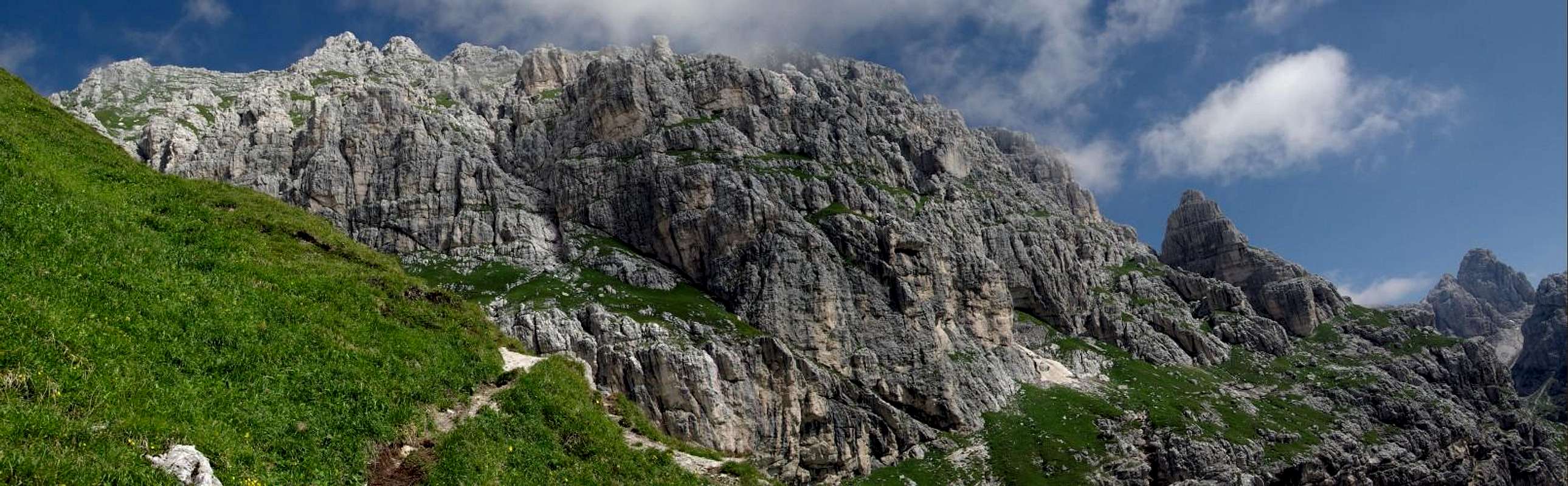
We go down for a couple of hundred meters until we meet a crossroad where we leave the main track taking the path ( n°626 ) on the left that goes to Forcella Lavinal Dell’Orso ( 2138 m ) where we can see the impressive abyss called Spragna and a fine view of the Montasio group. From the notch we turn left following the indications for the Sentiero Attrezzato Ceria-Merlone and we start to climb the steep NE face of Punta Plagnis.
 NE face of Punta Plagnis
 Montasio group
Some passages are very exposed but all well secured with the iron ropes. In this part we must be very careful of the many ibexes that can move rocks above our head. The last part of the route on the face is mostly on rocky or grassy ledges until it reaches a smooth slab where we will find an iron ladder. After that in a few minutes we’ll reach a small notch between Cima Cregnedul and Punta Planis. This is the first place where you can go back down to Casera Cregnedul in case of emergency, following an old mule track. From there the most beautiful part of the path begins. It’s a fantastic ride on extremely exposed ledges and crests that brings you first almost on the summit of the picturesque Cima della Puartate ( natural arch ) and then to the big amazing notch called Forca de la Val ( 2352 m, other place where the route can be abandoned ), where you can enjoy a stunning view of the king of this mountains, the great Jof di Montasio.
 Jof Fuart Jof Fuart |  La Puartate La Puartate |  Jof di Montasio Jof di Montasio |
After the notch we have to go down for 50 meters or so and then turn right until we reach the base of a dark ravine. This is technically the most difficult part of the route, but we are talking about passages of the II degree or a little more well protected with iron ropes, so you don’t need to be a climber to overcome this section. In the last part of the ravine you can find snow until august, so if you decide to do this route in early season be sure to bring with you ice axe, crampons and a rope. We are now at the base of the Modeon del Buinz heading towards the Sella Buinz and to the summit of Foronon del Buinz ( 2351 m, highest point of the route ), and this is really one of the most exciting parts of the route, since the views open wonderfully to every direction and there are rests of the First World War all around. The view from the Sella and from the summit of the Foronon del Buinz is absolutely breathtaking, in my opinion one of the best of the Julian Alps.
 Foronon del Buinz Foronon del Buinz |  Jof Fuart group Jof Fuart group |  Modeon del Buinz Modeon del Buinz |
 Jof Fuart Jof Fuart |  Canin group Canin group |  Altopiano del Montasio Altopiano del Montasio |
Then we start to go down first on the crest of the mountain and then on a long scree slope, sometimes interrupted with secured parts on rock and on exposed ledges. The last difficulties are on a ravine that brings you to Forca de lis Sieris ( 2274 m ), where the Sentiero Attrezzato ends.
 Cime Gambon
 Last view of Jof Fuart
This last part is also very interesting either for the many rests of the First World War and for the very strange pinnacles and rock formations. From the Forca you have just to follow the very long mule track that brings you just below Cima di Terrarossa, and from there to the Rifugio di Brazzà and to the car.
 Jof di Montasio Jof di Montasio |  Monte Canin Monte Canin |
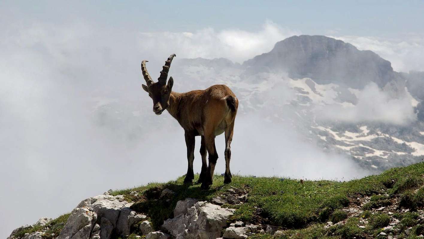
Ibexes of the Montasio Group
In the Montasio group there’s probably the highest number of ibexes/mq of the world! During a long route like this you’ll probably meet at least one hundred of them…Here are some pictures of them that I took the day I did this route. They really like to pose for the camera.
 |
|---|
 |  |  |
 |  |  |
Getting There
The Altopiano del Montasio is easily reachable from the small village of Sella Nevea by a narrow mountain road ( 6 km ).You can reach Sella Nevea either from Tarvisio ( indications for Cave del Predil ) or from Tolmezzo/Carnia ( exit of the Udine-Tarvisio motorway ) following the main road to Tarvisio and turning right after the village of Villanova.