
-
 2205 Hits
-
 79.78% Score
-
 11 Votes
|
|
Route |
|---|---|
|
|
45.86651°N / 10.69551°E |
|
|
Download GPX » View Route on Map |
|
|
Hiking, Via Ferrata |
|
|
Summer, Fall |
|
|
Most of a day |
|
|
Easy Via Ferrata |
|
|
Overview
 Cima Caset seen from Sentiero Mora-Pellegrini Cima Caset seen from Sentiero Mora-Pellegrini |
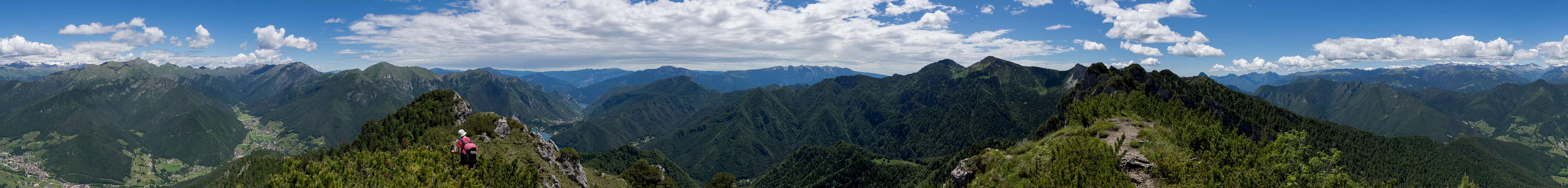
The description you find on this page deals with a long round trip from Lago di Ledro and back. The name refers to an easy Via Ferrata, which negotiates the ridge between Cima Caset and Monte Corno, the heart and soul of this round tour. There is only little protection, mainly in steep gullies, which have to be descended. Apart from these the sentiero winds between the numerous limestone towers on the ridge, always on very brittle ground. There is lots of scree and also lot of exposure, making the unprotected sections the most dangerous ones of the traverse.
Like so many Via Ferratas, Sentiero Mora-Pellegrini dates back to the first World War, when the frontline between Austria and Italy ran through Val di Ledro. While the northern ridge between Rocchetta Giochello and Dosso della Torta was in Austrian hands, the south, like on this ridge here was Italian. There are still two WW I positions on Cima Caset bearing witness of the trail's origin.
The remaining parts of the loop - outside Sentiero Mora-Pellegrini are easy but sometimes very steep hikes. The overall elevation gain is beyond 1300m.
Getting There
 Lago di Ledro seen from Monte Corno. Pur is to the very right.
The trailhead for the round tour is at Pur at the south of Lago di Ledro
- On Brenner Motorway A22 take the exit Roveretto Sud
- Switch to SS240 to Riva del Garda
- After the town follow the signs to Valle di Ledro still remaining on SS240.
- After Molina di Ledro, just as you reach the lake shore, turn south onto Via al Lago, which hugs the coast and heads for Pieve di Ledro along the southern and eastern shores.
- The trailhead at Pur is located to the south-east of the lake. There is a small parking lot at the intersection with Val di Pur
Route Description
  |
- General:
- Start altitude: 675m
- Summit altitude: 1781m
- Prevailing exposure: N and S
- Type: Hike, Via Ferrata
- Protection: Little protection of steep ascents/descents
- Start altitude: 675m
- Effort: 3 - Elevation gain: 1350m
- Power: 3 - Strenuous
- Psyche: 3 - Tricky, steep terrain
- Difficulty: 3 - Difficult (by hiking standards
- Orientation: 1 - Marked trails
From the parking lot in Pur follow the road into Val di Pur. At first there are some holiday homes but further inside the paved road turns to dirt. At Malga Cita a trail turns off south to Passo Nota. Instead, stay in the valley. The road turns into a path and heads up right into Val Scaglia, which it follows to its end on the high plateau of Malga Giù. Here, at Casera de Mez, a path turns north-westward towards Monte Corno, completely avoiding Sentiero Mora-Pellegrini.
 |  |  |  |
Instead follow a new dirt road, which passes Malga Giù to the south and then winds in long switchbacks towards Bocca Caset. In the the saddle you can choose between three routes: south to Monte Tremalzo, north to Tiamo di Ledro or north-west to Cima Caset (marked 456B).
 |  |  |
Follow this path, which negotiates a (currently burnt) slope, getting steeper as you close in on the first summit of the day. Cima Caset is rather unspectacular, a small bump on the ridge with a WW I position right on top. The path passes the summit but a few steps take you there. A 360° can only be had on top of the concrete frame of the WW I position. There are good views towards the Adamello Group.
 |  |  |
Descend back to the trail, which now runs along the southern side of the ridge. On its top you see the second WW I bunker, which, however, is not as easily reachable as the one on the summit. The path traverses into the saddle between Cima Caset and Cima Prubogn, a maze of limestone towers and start of the ferrata proper. A view back towards Cima Caset will tell you why the path avoided the ridge, as the summit consists uf a britle,, vertical limestone wall.
 |  |  |
The first few steps descending from Cima Prubogn are still an easy traverse through the aforementioned towers. You climb a steep section towards a side summit, where the path ends on top of a chimney-like gully. A bit of excellent protection (cable) leads to the gully and down into it, levelling out onto a narrow ledge, which negotiates between several picturesque smaller towers. Next you ascend through a rock window, then along the south slopes of the ridge, always winding up and down between the towers.
 |  |  |  |
Finally you find yourself on an unnamed summit with good ciews across the maze of towers behind you as well as the way ahead towards Monte Corno. Again, the path turns towards the southern side of the ridge (impressive views of Cima Prubogn), then turns towards the eastern side of the unnamed summit, whhere it ends above a long steep gully, which descends towards the saddle which separates Monte Corno from the remainder of the ridge. The gully is protected with a cable but also overgrown requiring some desperate moves to stay safe.
 |
From the saddle a marked trail leads up to Monte Corno. While not really difficult it is as brittle as the remainder of the ridge and thus can become dangerous in slippery conditions. The summit is reachhed after some 10 minutes and while it offers excellent views down to Lago di Ledro, its 360° panorama is obscured by trees on its south-western end.
 |  |  |
Return to the saddle where trail 456B leads steeply (and slippery) down to Bocchetta di Spinera. Here it enters the pine forest which it only briefly leaves at Chiesetta San Martino, a small chapel. The trail joins a dirt road which leads down to the lake shore of Lago di Ledro. Take the road (Via Europa) right, which will lead you back to your starting point in Pur.
Essential Gear
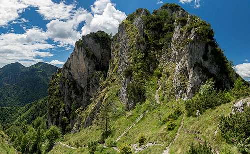 Nameless summit - Sentiero Mora-Pelllegrini runs through the overgrown gully to the right
Ferrata gear is virtually senseless. There are too few sections with protection. A helmet might be a good idea if you climb the traverse during the main season (July / August) when there are also other parties on the ridge.