
|
|
Route |
|---|---|
|
|
46.22140°N / 10.57030°E |
|
|
Hiking, Mountaineering, Scrambling, Via Ferrata |
|
|
Summer |
|
|
Most of a day |
|
|
EEA |
|
|
Overview
"Sentiero dei Fiori"
Corni di Lago Scuro 3166 m is a beautiful mountain located in the Adamello Group, well-known in reason of the presence of a true eagle's nest, the small Bivacco "Amici della Montagna - Faustinelli", a renovated WWI shelter located a few meters below the summit. Moreover it is popular in reason of a magnificent itinerary that reaches the summit along the route that the Italian alpine troops followed during the First World War to connect the stations installed on the ridges: the "Sentiero dei Fiori" (Path of Flowers).

|

|
The name "Sentiero dei Fiori", meaning "Flowers Trail", attributed to the itinerary is fairly improper and can mislead, as it is not really a simple path, but a Via Ferrata, which presents some easy equipped sections and airy passages on suspended bridges. It's also important to keep in mind that this itinerary, being exposed to the West, can often present some show still at the beginning of the summer.
")
Getting There
The starting point is Passo del Tonale 1883 m, connecting the Val di Sole (Trento province) with Alta Valle Camonica (Brescia province) to the West.
Road access to Passo del Tonale
- From Autobrennero (Trento or Bolzano) exit San Michele and take the road 43 through Val di Non and then Val di Sole, getting to Passo del Tonale.
- From Madonna di Campiglio (Val Rendena) take the road to Passo Campo Carlo Magno and Malè, here turn to left to Passo del Tonale
- From Brescia and Bergamo: the roads coming from Brescia and Bergamo combine near Darfo into the state road SS 42 Tonale and Mendola, which runs near the western borders of the Adamello Natural Park, crossing the villages of Boario Terme, Breno, Cimbergo, Paspardo, Cedègolo, Edolo, Temù and getting Ponte di Legno m. 1258 (66 km from Darfo), then Passo del Tonale.
Approach to Passo Paradiso
On Passo del Tonale reach the parking lot near the cable-car "Paradiso" and by the cable-car or alternatively by walking (3 hours) reach the Passo del Paradiso 2587 m.
Route Description
"Sentiero dei Fiori" report
Difficulty: EEA
Difference in level: 580 m from Passo Paradiso
Exposure: mainly West
Starting point: Passo Paradiso 2587 m
A beautiful way to get the summit of Corni di Lagoscuro. The route is best enjoyed in middle and late summer, when the snow is gone. Alternatively the difficulty can increase and the itinerary can require specific gear (ace-axe and crampons).

|

|
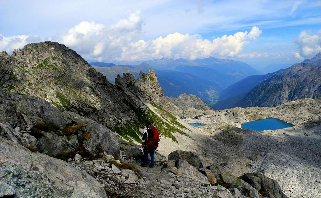
Route description From Passo Paradiso take the path n. 44, passing near a war-monument and heading rightward to reach the bottom of the moraine of Passo Castellaccio, located on the right of the basin. With a steep walk you reach the Passo del Castellaccio 2960 m. Here it starts the equipped itinerary, which is partially visible from here and described on a historical-descriptive table. Soon the route reachs an artillery station from which it starts a long ledge, at first equipped by iron caves and chains, then by wooden gangways.

|

|
A short deviation from one of these walkways is possible to reach the "eagle's nest" climbing up with the help of pegs and cable. After going back to the ledge and after the wooden gangaways, you reach the spire called Gendarme di Casamadre from which it starts the first airy suspended bridge 75 meters long. Some brackets aid the access to the impressive bridge, at the end of which a huge anchor allows the access to the second bridge, 55 meters long.

However, these airy bridges can be avoided through a 67 m war tunnel - built during the WWI - that requires the use of a front-torch. The entrance is a few meters before the first iron bridge. The war tunnel joins the itinerary at the end of the second bridge. After having turned an edge, reach an upper ledge, descend a little and reach a terrace from which it begins a long stretch of path without anchors and chains, crossing some slopes in the direction of a ridge to be overcome with the aid of some fixed equipment.

|

|

|

|

|

|
Throughout this stretch they may be present at the beginning of summer - according to the season's trend and precipitations - some snowy sections that may require the use of ice axe and crampons. In the upper part there are some equipped rocks, some boulders, then a good path and a short walk to the Bivacco Amici della Montagna, just a few meters below the summit of the Corno di Lagoscuro 3165 m., then the summit cairn.

|

|
Descent: the descent may be done reversing the same route, but the shortest way is to descend to Passo Lagoscuro (keeping the idrographic left hand)and reach Passo Presena. Apart the descent reversing the same route to Passo Castellaccio, this is the safest route to return.
Essential Gear
Via Ferrata set, harness and helmet, some slings.
Hiking Grades of difficulty
T - Turistico (Tourist): Itineraries on wide, clear and well worn paths, sometimes on mule tracks or gravel roads. The routes are never exposed, don't give any orientation problems and don't exceed 2500 meters of altitude. Suitable also for children
E - Escursionisti (Hikers): Itineraries on marked trails, even narrow and with possible steep and impervious sections. They are never exposed and don't give any orientation problems. They can tread different kinds of ground, such as forests, gravel, meadows, pastures, easy rocks, etc.). They form the majority of the trails that wind up in the mountains and require a certain habit to walk; you need equipment suitable for the altitude and resistant footwear with soles suitable for rough terrain EE - Escursionisti Esperti (Experienced Hikers): Itineraries for hikers with experience and good knowledge of the mountain. Some of these paths may have exposed sections, however brief, which require firm foot and no dizziness. They require the ability to adapt to particular terrain, such as steep grassy slopes or stretches of rocks with difficulties that can reach the 1st degree of the UIAA scale. They can also reach high altitudes (3000 m or more). Sometimes they may include unmarked sections, requiring a good sense of orientation. Snow slopes are possible, however which can be overcome without specific mountaineering gear (rope, harness, crampons, ice-axe)
EEA - - Escursionisti Esperti con Attrezzatura (Experienced Hikers with equipment - The same as EE, in addition these itineraries have short sections equipped with metal cables, stairs or pegs. Short stretches exposed require no dizziness, but not the use of specific technical material
Red Tape

No fees no permits required. Corno di Lago Scuro is situated within Parco Naturale Adamello-Brenta the largest protected area in Trentino, established in the year 1967. It's located in Western Trentino and with its 620.51 square kilometers includes the mountain groups of Adamello, Presanella and Brenta Dolomites.
When to climb

Best period goes from the end of June to middle September
Where to stay
Pay attention about the fact that the small shelter on the summit is only for emergency. There are different possibilities of accomodation both in Val di Sole and Val Camonica
Bibliography
"Adamello vol. II" - Pericle Sacchi, Collana Guide dei Monti d'Italia CAI-TCI
"Adamello - Presanella" map - 4LAND Alpine Cartography n. 138 1:25.000