The Plan
While hiking the Pacific Crest Trail, I briefly met Smiley, a fellow thru-hiker. The following year he sent me an email saying he wanted to come to Southern Peru to climb the Arequipa area mountains, and was looking for a partner. He said he was an experienced climber but didn't want to climb 20,000-foot mountains alone. He also needed transportation, which I could provide. I couldn't remember where we had met, or picture what he looked like, but the name sounded familiar, and after a time of communication we worked out the time and details. Not too long before he was to arrive, I heard from another Summit Post member named Nathan, and he wanted to come down at the same time. Smiley was concerned that Nathan might hold us back because he was a "lowlander" but after seeing his climbing resume and discussing the situation, we all decided to give it a try and see how it would work together.
Nathan was able to come a couple of days earlier and we got in a couple of conditioning climbs, one on Chachani and one on Pichu Pichu. In spite of going right from the airport for the first one, and a headache from the altitude, he did fine. The following day we picked up Smiley at the airport and planned our attack. Smiley wanted to climb as many mountains as possible, but his big three were Nevados Chachani, Ampato and Coropuna, all over 6,000 meters, as well as El Misti which is just under that. We were thinking of trying Volcan Ubinas as a conditioning climb, but it had just been erupting so we chose Pichu Pichu instead.
(This is a long report so I decided to put some of the mountains that were new to me on separate pages.)
Nevado Pichu Pichu – 18,586 Nov. 30th
![Pichu Pichu from El Misti]() Pichu Pichu from El Misti
Pichu Pichu from El Misti:
El Misti – 19,101 feet Dec. 1st & 2nd
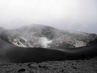
![El Misti Crater]() El Misti Crater
El Misti Crater![Summit Cross On El Misti]() Summit Cross On El Misti
Summit Cross On El Misti![High Camp, El Misti]() High Camp, El Misti
High Camp, El Misti![After a Successful Climb]() After a Successful Climb
After a Successful ClimbIt was late when we got home from Pichu Pichu so the next day we slept in and took it easy in the morning. Besides the rest, we wanted lots of good food so we decided to stop at El Herraje Restaurant for lunch before heading to Misti. El Herraje has two locations in Arequipa, the one near the Cathedral is large, touristy and expects tips, a smaller one two blocks away caters to the locals and tipping is not expected. They have a grill special, with a choice of chicken, beef or pork, generous portion of fries and a salad for 7 or 8 soles – the perfect way to start any climb. Or to end a climb; we became regulars there during our time in Arequipa.
There are three main trails up Misti. What used to be the normal one starts near the city dump and is considered quite dangerous due to the gangs of robbers that hang out there, waiting for climbers to return. The one on the northeast side is higher in elevation, and a shorter climb, but has a long rough approach drive between Misti and Chachani. The trailhead we used is on the south side; the turn off is near the village of Chigata, which is reached by the same road used to go to Pichu Pichu. It is still near enough to the city that it is not recommended to leave a vehicle parked there overnight, so my friend Lucho drove us to the trailhead. We got started later than planned because the road had been closed for a road race; one of the cars was still there when we went by, over the edge down in a canyon.
We had some trouble finding the trailhead as it had been years since I had been there and there are no signs for the multitude of roads, some of which dead-end in small canyons. Finally we found the correct road and at 3:15 pm we had our picture taken at the National Reserve sign (11,600 feet) and headed up towards the camp. We arrived at the first camp in 2 ½ hours, which is at 14,920 feet, but it was pretty full with another party and their three tents. We visited for a while and got some pictures of Pichu Pichu in the clouds, and then we went on (while being treated to a fabulous sunset!) to the higher camp at 15,420 feet. We arrived there at 6:30, feeling great and just in time to get our tents set up before dark.
Unfortunately Smiley had a bad night - a severe headache and breathing problems, with only a few hours of sleep. Thankfully the headache lessened at about 6:00 am so we got up then and were on the trail at 6:45. Most groups start by 3:00 am or before but knowing we would be climbing fast, we weren't worried about the late start. Smiley was feeling much better, but I continued to lead, setting a slow (for them) but steady pace. At 9:15 we caught up to the group that had been camped below us, and after a short break, we went on ahead of them. After a couple of photos at the saddle on the crater rim, Smiley and Nathan took the lead for the last climb up the rim and reached the summit at 10:05, three hours and 20 minutes from camp. A few minutes later I joined them there and we visited with another group who had come up the backside, while enjoying the view and taking photos. Of course we got a good look at Chachani, where we would be the next day. On the way down, we took the traverse trail to the lower crater, which is still active. There we could look down through the sulfur fumes to the base of the crater where mummies were discovered a number of years ago.
One of the fun things about a Misti climb is the very quick slide down the steep volcanic sand; we were back at our camp in an hour and 15 minutes, where we dumped out shoe fulls of sand. After packing up, we continued the rapid descent, arriving at the trailhead at 1:50 for a total descent time of three hours, including the 40-minute stop to pack up camp. Total time from leaving camp in the morning until returning to the trailhead was seven hours and five minutes, which beat my previous time by two hours. Unlike the previous climb, there was no snow at all on Misti this time.
Nevado Chachani – 19,872 feet Dec. 3rd & 4th
![Nevado Chachani From El Misti]() Nevado Chachani From El Misti
Nevado Chachani From El MistiNevado Ampato – 20,630 feet Dec. 5th & 6th
![Nevado Ampato From Chachani]() Nevado Ampato From Chachani
Nevado Ampato From ChachaniHuarancante – 17,716 feet Dec. 7th - Bonus Peak
![A Little Scrambling]() A Little Scrambling
A Little Scrambling![Ridge Climb To Huarancante]() Ridge Climb To Huarancante
Ridge Climb To Huarancante
There are also two more mountains that can be accessed from the same base camp, the closest one is Nevado Hualca Hualca, which at 19,780 feet is also over 6,000 meters, the other one is Sabancaya, an active volcano at 19,619 feet. We were all pretty wiped out so decided not to climb either of them, but on the drive back to the highway the next day, Nathan and Smiley were talking about bagging a small peak, so as not to waste the whole day! They decided on Huarancante (17,716 feet) as it was right near the highway and looked like a quick climb. We weren't sure of the best approach, but finally found a long ridge heading in that direction, and parked along the road at 15,640 feet. I decided I better stay in the van and rest, and I was also a little concerned about it starting, as it was a cool day, so I started it every couple of hours. Smiley and Nathan took off at 11:05 and didn't get back until 6:05. It turned out they were a lot farther from the mountain than we had thought so it wasn't the quick and easy summit they were expecting. (With this one, they did a total of eight summits.)
Nevado Mismi – 18,465 feet Dec. 8th
![Saving a Marathon]() Saving a Marathon
Saving a Marathon![Cross Country To the Summit]() Cross Country To the Summit
Cross Country To the Summit![Some Down Climbing Required]() Some Down Climbing Required
Some Down Climbing Required![Nevado Mismi Summit Ridge]() Nevado Mismi Summit Ridge
Nevado Mismi Summit Ridge![Heading Back To the Van]() Heading Back To the Van
Heading Back To the Van![What Happened To Our Sunny Day?]() What Happened To Our Sunny Day?
What Happened To Our Sunny Day?
Saturday morning when we were ready to leave Chivay someone said it was supposed to rain, but it was clear and sunny so we laughed and thought they must have been wrong. We drove to Tuti and found the road to Mismi, the sign said it was 26 Km. It was a decent gravel road to start with but after we got up on the high plain it got confusing. We could see the mountain but after heading towards it for a while the road took off in a straight line away from it. There hadn't been any road going towards Mismi, nor a sign saying we had arrived at a trailhead or anything. We backtracked and found a faint set of vehicle tracks going in the right direction so followed those. It kept getting rockier and we thought a number of times that we were at the end of the "road" and then we would see the tracks going around some rocks and continuing. Finally after 28 Km and at 17,050 feet and at 10:15 am, we stopped and parked as the tracks turned away from the mountain.
There was no obvious trail so we just headed in the general direction, trying to find the best route over the rocks, hills and valleys. As we got closer to the summit ridge, which has a number of peaks, we finally saw a few cairns and some faint trails. We reached the first peak at 12:45 and continued along to the summit, reaching there at 1:20. By now it was cloudy, windy and cold so we didn't stay there long. We didn't see any marker or indication that it was the summit, but it was the peak that the rescue police told us was the summit and it registered the highest on my GPS at 18,420. There is a large variation in elevations given in different sources and none on the topo map, just like for Pichu Pichu.
As we started down, there were a few snow flurries, which had become quite heavy by the time we got back to the van at 3:15, for a total time of five hours. It continued to snow for a while on the drive down but had stopped before we got back to Tuti at 4:35. We decided to return to Arequipa that evening, take the day off on Sunday, and then head towards Cotahuasi on Monday, where we would climb Nevado Coropuna.
Nevado Coropuna – 21,079 feet Dec. 10th, 11th & 12th
![Ready To Climb]() Ready To Climb
Ready To Climb![Lower Base Camp By Laguna Pallacocha]() Lower Base Camp By Laguna Pallacocha
Lower Base Camp By Laguna Pallacocha![Our High Camp]() Our High Camp
Our High Camp![The Glacier To the Left of the Summit]() The Glacier To the Left of the Summit
The Glacier To the Left of the Summit![Nevado Solimana to the Left of Coropuna Glacier]() Nevado Solimana to the Left of Coropuna Glacier
Nevado Solimana to the Left of Coropuna Glacier![This Shows the Angle of the Climb]() This Shows the Angle of the Climb
This Shows the Angle of the Climb![Going Up the Glacier]() Going Up the Glacier
Going Up the Glacier![On the Summit of Coropuna]() On the Summit of Coropuna
On the Summit of Coropuna![Good To Be Off the Mountain Now]() Good To Be Off the Mountain Now
Good To Be Off the Mountain Now![Daniza and Her Little Sister]() Daniza and Her Little Sister
Daniza and Her Little SisterAfter a good days rest on Sunday, we left Monday morning for Coropuna, about a six-hour drive from Arequipa. The route first goes across the coastal desert and then through the fertile farmland of the Majes Valley, before starting the climb up to Chuquibamba, where the pavement ends. From Chuquibamba the gravel road climbs up to about 13,000 feet to the high plain, where you get your first view of Coropuna, the Chila range, and if the weather is clear, Ampato. Climbers who take the public bus, get off at a dilapidated building below Lake Pallacocha (which is not visible from the road), and either camp at the building or hike up 15 minutes to the lake to camp. There is also a road to the lake about five minutes past this site, so we drove up there and camped at 15,700 feet, rather than drive to the highest base camp at 16,470 feet. We arrived there just as it got dark, but we managed to find a few cleared tent sites among all the rocks.
In the morning we slept late and then looked around the lake for a while, before making the short drive up to the high base camp, which is about as far as you can drive. There are less rocks here and many good tent sites, with a large boulder to shelter somewhat from the wind. We parked the van, had lunch and started hiking at 1:30 pm. It was sunny with some wispy clouds, and a bit cool due to the wind and high elevation. The road does continue for a while but it was not possible to drive much farther because of a rock-strewn gully, just a few minutes from the base camp. We hiked up the road until that turned to go around the west end of the mountain at about 17,000 feet. From there we followed a faint climber's trail towards the west rib, which is the main route to the summit. Our route took us off to the left and followed an undulating ridge, rather than going directly towards the west rib, because there is a deep gully there and the climb up out of it would have been in steep, loose sand.
On my first climb a few years ago, we had camped higher up at snow line, but this time we decided to stay down lower as we found a nice sheltered site at about 18,200 feet, just below the glacier between the peaks. We had been going slow, I guess the previous week's climbing had taken a lot out of us; and the lower camp saved us from having to take full packs up the steep rocky section to the higher camp. We reached our campsite at 4:36 and settled in early, hoping to get a good night's sleep. Unfortunately it was another rough night for Smiley, just like the night before, with a bad headache and difficulty breathing. For some reason he was not acclimating to the altitude as well as he normally does, although he usually did fine during the day.
Wednesday morning, we left camp at 6:20 in a cold wind and bright sun, with only a few wispy clouds over the summit. We climbed up the steep rocky section on a faint trail, but after that there wasn't much sign of one. There are a couple of less steep areas but it is a hard climb the whole way, due to the altitude and lack of a trail. We passed the high camps and then came to the start of the steep ridge between the glacier. At 9:15 we reached the top of the ridge at 20,100 feet and stopped to put on our crampons before starting on the glacier. On my previous climb, we had roped up here, and then traversed over to a ridge that wasn't as steep; but this time we went straight up and without a rope. The climb was about 45 degrees with patches of ice, but the penitentes weren't near as bad as they often are. I was fairly comfortable with the climb after having done all the passes on the PCT in the Sierras without crampons, but wasn't sure about coming back down here. By the time we got up to the long traverse to the summit, I was going pretty slow and had fallen behind Smiley and Nathan, but caught up to them at a break before the final summit push.
They reached the summit at 11:30 and I arrived a few minutes later. It was still sunny, the wind had died down a little and it was a balmy 34 degrees at 21,079 feet. The top half of the summit pole was missing, there was almost no snow on Solimana but the views were still great and after photos and resting, we started down at 12:00 noon. I was hesitant about going back down the steep part of the glacier but with Smiley and Nathan leading the way, and the now softer snow, we all made it back to the rock ridge with no problem, arriving there a few minutes after 1:00 pm. There were now some clouds rolling in from the south but it was still clear where we were and on the summit. By 3:00 we were back in camp and there were high clouds over the summit. We took the direct route back to the car, making quick time down the steep sand, and were back at the van at 4:20 for a 10-hour summit day. By this time the summit was totally covered in clouds, which extended down to the top of the rocky ridge. With a little earlier start from this high base camp and a lighter load, it could be a reasonable day hike.
On the way to Cotahuasi, Daniza, my favorite little roadside beggar met us on the road just above her house, along with her little sister, shyly accepting the food we gave them. We were home in Cotahuasi by 7:30, happy and tired. We decided to take a break from climbing and go to Sipia Falls the next day, and climb Cerro Lucmani the following day.
Cerro Lucmani – 16,924 feet Dec. 14th
![A Stormy Day On Lucmani]() A Stormy Day On Lucmani
A Stormy Day On LucmaniWhat To Do For an Encore?
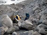
![Lots of Graves Were Dug Up]() Lots of Graves Were Dug Up
Lots of Graves Were Dug Up![Bones Everywhere!]() Bones Everywhere!
Bones Everywhere!![A Cute Little Pot]() A Cute Little Pot
A Cute Little Pot![Athletes Foot?]() Athletes Foot?
Athletes Foot?![It Looks Like It Was Dissected]() It Looks Like It Was Dissected!
It Looks Like It Was Dissected!On Saturday we went to Huito Rock Forrest above Pampamarca and finally got to see a condor, as well as the tombs along the trail and Uskuni Falls. The next day we drove back to Arequipa, stopping to see the pre-Inca cemetery near La Real with was fascinating. Hundreds of graves, lots of artifacts, bones everywhere, many skulls and even a mummy that was just laying out in the open in a grave. We also stopped at Toro Muerto to see the petroglyphs but we didn't find that nearly as impressive, so cut that short and headed back to Arequipa.
It was a great trip for all us; it was the most mountains any of us had climbed in such a short time. The weather was mostly good so we didn't have to take any days off for the weather, which enabled us to climb more than we had planned for. I added one more 6,000-meter peak to my list, but still need to go back and get to the top of Ampato, hopefully later this year. Nathan stayed a few extra days and even managed to climb Volcan Ubinas after a short retreat for an eruption!


Comments
Post a Comment