
-
 25033 Hits
-
 89.77% Score
-
 30 Votes
|
|
Area/Range |
|---|---|
|
|
31.87740°N / 111.2156°W |
|
|
Hiking |
|
|
Spring, Fall, Winter |
|
|
6188 ft / 1886 m |
|
|
Overview
 Looking south down Ox Frame Canyon
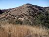
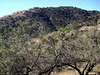
Roughly 50 miles southwest of Tucson, Arizona and immediately west of the twin communities of Green Valley and Sahaurita rise the Sierrita Mountains. (Local phonetic pronunciation is roughly "The Suh-REET-uzz.") The name is a bit odd, of course, somewhat like saying “The Little Mountain Mountains.” These are mid-elevation, somewhat scrubbier peaks that lack both the grandeur of Arizona alpine summits as well as the rugged charm of the lower, true desert ranges. The Sierritas, however, are relatively convenient to the Tucson area and, best of all, include an Arizona 2,000 ft. prominence peak, Keystone Peak.
These lower, gentle hills, cut deeply by valleys, offer pleasant solitude, a rich dose of history and a curiously enjoyable “non-park” experience. The hillsides are speckled with oak woodland and chaparral, tall grasses, cholla and prickly pear. Mining has left its mark historically on the slopes and current mining operations continue to cut away at the land. Cattle will likely be encountered grazing on the land. The highpoint, Keystone Peak, is festooned with communications towers. Your hike may be pleasantly “interrupted” by friendly smiles and neighborly waves from local residents or even mine workers.
Primary image courtesy of surgent.
Views from the Sierrita Mountains
Views abound from the summits of the Sierritas, particularly those of the Santa Ritas, the Coyote Mountains and the Baboquivari Mountains anchored by the famous Baboquivari Peak. The views southward into Mexico are astounding. Baboquivari from Keystone Peak Baboquivari from Keystone Peak |  Santa Ritas Santa Ritas |  Coyote Mountains Coyote Mountains |
Getting There

Major Roadways for Access to the Sierrita Mountains
From the East: I-19
Primary access from the east is via McGee Ranch Road. You will reach a locked ranch gate at a water tower about 4.5 miles west of Mission Road. Parking is available around the water tower.
Do not attempt to head west on Pima Mine Road to access the Sierritas to avoid trespassing.
The southeast access via the Canoa Road exit is complicated by private property, most notably Caterpillar Equipment Tucson Proving Ground and the Duval Mine dump.
From the West: Hwy 286
Primary access to the the northwest side of the Sierrita mountains from Tucson is via Ajo road (Hwy 86) to Sierrita Mountain Road. Head south on Sierrita Mountain Road until the pavement ends. Follow the road as it trends southward, it will take you to the base of the mountains.
Investigating access via the joint Pima County / State Trust Diamond Bell Ranch area clarify access issues on this part of the range.
From the North: Hwy 86
Primary access to the the northwest side of the Sierrita mountains from Tucson is via Ajo road (Hwy 86) to Sierrita Mountain Road. At Diamond Bell Road (paved), follow the dirt road eastbound. Be certain to monitor signs and not to stray onto Tohono O’Odham tribal lands.
From the South: Arivaca Road
Access to the southern end of the range can be obtained from Arivaca Road around mile marker 18, but I know little about land ownership in this area.
Excerpted from Arizona Game & Fish Department.


Red Tape and Property Ownership, Management & Access
Overview
Property ownership of and public access to the Sierritas is, as they say, clear as mud. Property holdings are a checkerboard of confusion with private and public holdings intermingled. Access, particularly from the east via McGee Ranch Road, has traditionally not been an issue. Please be friendly and respectful to all people you encounter and clean up after yourself, your party and others to ensure continued enjoyment of this area for the public.
To give a feel for the complexity of land ownership in this area:
In October 1998, Pima County Administrator Chuck Huckleberry submitted a proposal to the County Board of Supervisors to turn the mountains around McGee Ranch into a park as a core component of a habitat conservation system for the county. A map accompanying the proposal outlined park boundaries that encompass 10,904 acres of state land, 5,870 acres of federal (Bureau of Land Management), and 4,348 acres of private.*
*A place for dialogue: language, land use, and politics in Southern Arizona
- By Sharon McKenzie Stevens, Wayne Franklin
McGee Ranch & Settlement
Not the only privately-owned land in the area, but probably the best known is the area collectively knows as the McGee Ranch & Settlement.
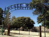 McGee Ranch Cemetery
The settlement on the eastern side of the Sierrarita Mountains dates to 1895 “when goldseekers James Riley McGee, David Lively, George Harris, and their families traveled west by wagon train toward California. When a wagon wheel broke, down at Chigger Hill, they stopped to repair the wheel and pan for gold. In 1898 they settled a permanent camp, predating Arizona statehood. Three years later a prospector guided them to an abandoned ranch where an English homesteader left a fireplace, a rock sheep and goat corral, fig and apricot trees, grape, bean, “squaw corn” fields. The settlement continues there today.*
*Green Valley, Arizona
- By Philip Goorian
Mining Claims
 Old mining drift opening
There appear to be mining claims great and small in the area. One of the major mining land owners in the area is Phelps-Dodge. And, per Arizona Game and Fish, it is their reaction to certain visitor use issues that is causing increasing red tape in the Sierrita's:
As of August 2004 the McGee Ranch Access road has been locked off by Phelps Dodge Mining Corporation. Access is still allowed up to the locked gate but vehicles can no longer access the mine property for liability purposes. The Game and Fish Department and the McGee Ranch are currently working on an alternate route but until a right of way can be approved and constructed, Sportsman will not be able to access the area owned by Phelps Dodge. This area will lock off access to the roads around Horse pasture Hill.
Phelps Dodge was concerned about vandalism problems, target shooting, unsafe OHV use, and camping on their property. They also had an incident occur when a target shooter shot through the windshield of one their trucks while the operator was driving down a mine road.
State Trust Lands
 | State Trust lands, in Arizona as in many neighboring states, are frequently leased to private owners for grazing, logging or other surface activities. The Arizona State Trust lands here are apparently no exception. The checkerboard pattern is maddening for the casual recreationalist, but the good news is that recreational use of these lands is traditionally respected. Let's keep up the good faith of the lease-holders as a climbing community and not abuse this trust. |
Bureau of Land Management
The BLM apparently owns at least nearly 6,000 acres in this area, though I can find very little about the lands it manages or the presence of the BLM in the Sierrita Mountains.
Notable Peaks of the Sierrita Mountains
|  |


Wildlife
 Gruesome Find
Per the Arizona Game & Fish Departments, critters inhabiting these mountains include Javelina, Mule Deer, White-tailed Deer, Cottontail Rabbit, Dove and Quail. I would not be shocked one bit to know Mountain Lion and Coyote haunt these parts, as well. During one visit I found a fur-on pair of deer legs removed from their body and cannot imagine the deer did so herself.
Climate: Weather & Seasons
 Agave in the Sierrita Mountains
| Month | Avg High | Avg Low | Mean | Precip | Rec High | Rec Low |
|---|---|---|---|---|---|---|
| Jan | 66°F | 40°F | 53°F | 0.94 in | 88°F (1927) | 6°F (1913) |
| Feb | 69°F | 42°F | 56°F | 0.89 in. | 92°F (1957) | 17°F (1899) |
| Mar | 74°F | 46°F | 60°F | 0.73 in. | 99°F (1988) | 20°F (1965) |
| Apr | 82°F | 52°F | 67°F | 0.31 in. | 104°F (1989) | 27°F (1945) |
| May | 92°F | 61°F | 77°F | 0.23 in. | 111°F (1910) | 32°F (1899) |
| Jun | 100°F | 69°F | 85°F | 0.20 in. | 117°F (1990) | 43°F (1908) |
| Jul | 100°F | 75°F | 88°F | 2.25 in. | 114°F (1995) | 49°F (1911) |
| Aug | 97°F | 73°F | 85°F | 2.39 in. | 112°F (1993) | 55°F (1917) |
| Sep | 95°F | 69°F | 82°F | 1.29 in. | 107°F (2000) | 43°F (1913) |
| Oct | 85°F | 57°F | 71°F | 0.89 in. | 102°F (1993) | 26°F (1971) |
| Nov | 74°F | 46°F | 60°F | 0.57 in. | 94°F (1924) | 19°F (1921) |
| Dec | 65°F | 39°F | 52°F | 0.93 in. | 85°F (1939) | 10°F (1901) |
 Click for weather forecast | In general, expect mild temperatures in winter, often sunny and dry by day and cold and clear at night. The heat in the summer can be extreme and even dangerous. Use caution during the summer monsoon season as washes can flood during heavy rains. |  Click for weather forecast |