
-
 17005 Hits
-
 71.06% Score
-
 1 Votes
|
|
Trailhead |
|---|---|
|
|
47.94855°N / 113.85218°W |
|
|
Lake |
|
|
Summer, Fall, Winter |
|
|
4200 ft / 1280 m |

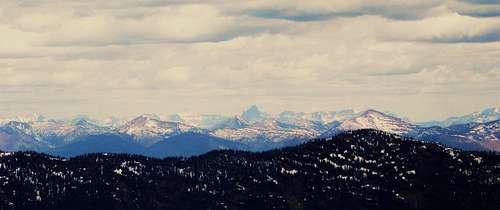 Views of Glacier National Park from Six Mile Peak
Six Mile Mountain provides rewarding views into the Flathead Valley with Swan and Flathead Lakes clearly visible. Also seen from the summit are the Missin Mountains, Glacier National Park and large portions of the Bob Marshall Wilderness.
Six Mile Mountain Trail # 10
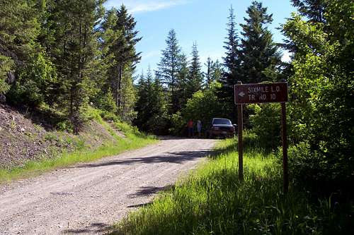 The Trailhead
 Sign by the road
Directions to the Trailhead:
 A Topo of the Road to the Trailhead
The road to Six Mile Trail # 10 is located just north of Swan Lake, Montana on Montana Highway 83. The road to the trailhead is directly North of National Forest Service Swan Lake Campground. Bigfork, Montana the nearest decent gas and fuel supply is another 14 miles north on Highway 83.
After turning east off the highway onto Road # 9508 drive 4 miles over the gravel road to the trailhead that is marked by Six Mile LO trailhead sign.
The trail has two additional opportunities to get turned around so make sure you carry a map. Maps can be purchased from most sporting goods stores as well as any National Forest Service office in western Montana.
Approximate GPS Way Points:
 A Terra Server Image of the Road
Trailhead: Lat. ≅ 47.94855 Long. ≅ -113.85218 Elev. ≅ 4,200 feet
Weed Lake Trail Junction: Lat. ≅ 47.95852 Long. ≅ -113.85205
Alpine Trail #7 Junction: Lat. ≅ 47.97584 Long. ≅ -113.82746
Six Mile Peak summit: Lat. ≅ 47.98647 Long. ≅ -113.84471 Elev. 7,406 feet
Total Elevation Gain from Trailhead to Six Mile Summit ≅ 3,200 feet.
Total round-trip distance ≅ 11 miles.