
-
 21545 Hits
-
 80.49% Score
-
 12 Votes
|
|
Mountain/Rock |
|---|---|
|
|
47.98620°N / 113.844°W |
|
|
Lake |
|
|
Hiking |
|
|
Spring, Summer, Fall, Winter |
|
|
7406 ft / 2257 m |
|
|
Overview:
Layout designed for best viewing on a "1024 x 768" screen.
 The Summit of Six Mile Peak
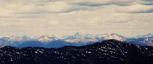 Glacier National Park from Six Mile Peak
 Glacier National Park from Six Mile Peak
Located in Montana's Swan Range
Incredible views, no crowds and an easy trail to the summit makes this peak a nice alternative to the lung busting climbs of Glacier National Park.
Check out Six Mile Peak on a rest day.
Six Mile Peak is located in the Swan Range approximately 14 miles southeast of Bigfork, Montana. Summit views include the Nyack region of Glacier National Park and The Great Bear Wilderness to the East, The Bob Marshall Wilderness to the Southeast, The Swan Range to the South and to the Southeast are the rugged Mission Mountains, Flathead Valley to the Northwest, and finally to the North The Jewel Basin and more mountains of Glacier National Park.
Direct views into the valley floor yield a look at numerous small lakes that dot the landscape. A 360 degree turn will also yield views of three large bodies of water: Flathead Lake to the northwest, to the West is Swan Lake to the East between the Swan Range and The Great Bear Wilderness is the forever dammed South Fork of the Flathead River and Hungry Horse Reservoir.
The Views:
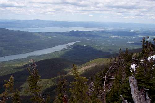 The Flathead valley with Swan and Flathead Lake
![Six Mile Peak]() The Swan Valley
The Swan Valley
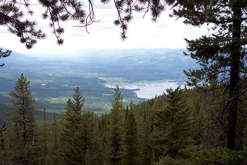
![Six Mile Peak]() Hall Peak
Hall Peak
![Six Mile Peak]() The Jewel Basin to the north
The Jewel Basin to the north
Getting There:
![Six Mile Peak]() Nearing the junction of trails #10 and #7
Nearing the junction of trails #10 and #7
Six Mile Mountain is located in northwestern Montana. The route is located off of state Highway 83 just North of Swan Lake, Montana. The Six Mile Mountain turn off is approximately 2/10 mile north of the 72 mile marker.
The nearest airport, Glacier International Airport (FCA), is located in Kalispell. The area is also serviced by Amtrak in Whitefish. Main highways into the Flathead Valley are Highways 2 and 93. The Flathead Valley is approximately 120 miles North of Missoula, Montana and Interstate 90.
Detailed trailhead information can be found at Six Mile Mountain Trail #10.
Red Tape:
![Entering Griz Country]()
![Black Bear Scat]() Bear Scat at the trailhead
Bear Scat at the trailhead
There are no trail restrictions on the Six Mile Mountain trail so expect to possibly share this trail with four-footers as well as bicycles and motorbikes.
As with all hiking and climbing in bear country, use caution and practice good manners with the wildlife. Carry your bear deterrent, don’t hike alone and make some noise. For more information please go to the Glacier National Park's website for Bear Information. The U.S. Forest Service also has helpful information on Grizzly Bear Management.
Route Overview:
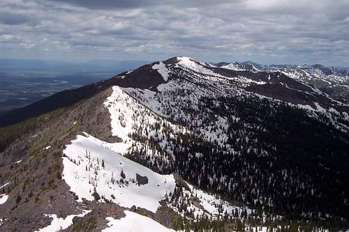
![Six Mile Peak]() Six Mile Peak from below the east ridge
Six Mile Peak from below the east ridge
Total round trip distance is 11 miles. Total elevation gained is approximately 3,400 feet.
Six Mile Mountain has a trail from the trailhead to the summit. For complete route statistics please see the GPS Way Points along the trail below.
The trail passes through old growth timber for the first 3 miles and then begins to open up as it nears the junction of Alpine Trail #7. From Alpine Trail #7 to the summit there is a mix of vistas and trees.
Plan on being in snow if climbing before July 4. The route is easy to follow and rewarding views await at the summit.
GPS Way Points along the Trail:
Trailhead: Lat. ≅ 47.94855 Long. ≅ -113.85218 Elev. ≅ 4,200 feet
Weed Lake Trail Junction: Lat. ≅ 47.95852 Long. ≅ -113.85205
Alpine Trail #7 Junction: Lat. ≅ 47.97584 Long. ≅ -113.82746
Six Mile Peak summit: Lat. ≅ 47.98647 Long. ≅ -113.84471 Elev. 7,406 feet
Total Elevation Gain from Trailhead to Six Mile Summit ≅ 3,200 feet.The Six Mile Lookout:
![Six Mile Lookout Burning]()
![Six Mile Lookout Burning]()
In 1910 a Crowsnest Lookout was erected at the summit of Six Mile Peak.
In 1928 a cupola cabin style lookout was built.
It was burned in 1975 by the USFS. More than likely it had been vandalized and was no longer safe.When To Climb:
It is possible to climb at any time of the year. Ideal times to climb are July to September. Alpinists will experience a higher degree of challenge earlier and later in the season. The road to the trailhead will not be plowed if there has been snow.
If there is a lot of snow consider climbing to the ridge immediately northwest of the junction of Six Mile Trail #10 and Alpine Trail #7. It is an easy ridge walk to the summit and avoids a lot of snow on the sidehill of the east side of the ridge.Weather and Equipment:
In Montana it is said “If you don't like the weather just wait a half hour” or you can check out what’s up with the local weather at Swan Lake Weather.
No special equipment is needed for this route with the exception of sturdy boots and water. Plan on carrying Bear Deterrent Spray as well since this is bear country.
Plan on additional gear if an early season attempt is made.Links:
Visit Montana
 The Swan Valley
 Hall Peak
![Six Mile Peak]() The Jewel Basin to the north
The Jewel Basin to the north
Getting There:
![Six Mile Peak]() Nearing the junction of trails #10 and #7
Nearing the junction of trails #10 and #7
Six Mile Mountain is located in northwestern Montana. The route is located off of state Highway 83 just North of Swan Lake, Montana. The Six Mile Mountain turn off is approximately 2/10 mile north of the 72 mile marker.
The nearest airport, Glacier International Airport (FCA), is located in Kalispell. The area is also serviced by Amtrak in Whitefish. Main highways into the Flathead Valley are Highways 2 and 93. The Flathead Valley is approximately 120 miles North of Missoula, Montana and Interstate 90.
Detailed trailhead information can be found at Six Mile Mountain Trail #10.
Red Tape:
![Entering Griz Country]()
![Black Bear Scat]() Bear Scat at the trailhead
Bear Scat at the trailhead
There are no trail restrictions on the Six Mile Mountain trail so expect to possibly share this trail with four-footers as well as bicycles and motorbikes.
As with all hiking and climbing in bear country, use caution and practice good manners with the wildlife. Carry your bear deterrent, don’t hike alone and make some noise. For more information please go to the Glacier National Park's website for Bear Information. The U.S. Forest Service also has helpful information on Grizzly Bear Management.
Route Overview:
![Six Mile Peak]() Six Mile Peak from below the east ridge
Six Mile Peak from below the east ridge
Total round trip distance is 11 miles. Total elevation gained is approximately 3,400 feet.
Six Mile Mountain has a trail from the trailhead to the summit. For complete route statistics please see the GPS Way Points along the trail below.
The trail passes through old growth timber for the first 3 miles and then begins to open up as it nears the junction of Alpine Trail #7. From Alpine Trail #7 to the summit there is a mix of vistas and trees.
Plan on being in snow if climbing before July 4. The route is easy to follow and rewarding views await at the summit.
GPS Way Points along the Trail:
Trailhead: Lat. ≅ 47.94855 Long. ≅ -113.85218 Elev. ≅ 4,200 feet
Weed Lake Trail Junction: Lat. ≅ 47.95852 Long. ≅ -113.85205
Alpine Trail #7 Junction: Lat. ≅ 47.97584 Long. ≅ -113.82746
Six Mile Peak summit: Lat. ≅ 47.98647 Long. ≅ -113.84471 Elev. 7,406 feet
Total Elevation Gain from Trailhead to Six Mile Summit ≅ 3,200 feet.The Six Mile Lookout:
![Six Mile Lookout Burning]()
![Six Mile Lookout Burning]()
In 1910 a Crowsnest Lookout was erected at the summit of Six Mile Peak.
In 1928 a cupola cabin style lookout was built.
It was burned in 1975 by the USFS. More than likely it had been vandalized and was no longer safe.When To Climb:
It is possible to climb at any time of the year. Ideal times to climb are July to September. Alpinists will experience a higher degree of challenge earlier and later in the season. The road to the trailhead will not be plowed if there has been snow.
If there is a lot of snow consider climbing to the ridge immediately northwest of the junction of Six Mile Trail #10 and Alpine Trail #7. It is an easy ridge walk to the summit and avoids a lot of snow on the sidehill of the east side of the ridge.Weather and Equipment:
In Montana it is said “If you don't like the weather just wait a half hour” or you can check out what’s up with the local weather at Swan Lake Weather.
No special equipment is needed for this route with the exception of sturdy boots and water. Plan on carrying Bear Deterrent Spray as well since this is bear country.
Plan on additional gear if an early season attempt is made.Links:
Visit Montana
 The Jewel Basin to the north
Getting There:
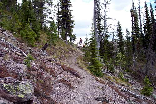 Nearing the junction of trails #10 and #7
Six Mile Mountain is located in northwestern Montana. The route is located off of state Highway 83 just North of Swan Lake, Montana. The Six Mile Mountain turn off is approximately 2/10 mile north of the 72 mile marker.
The nearest airport, Glacier International Airport (FCA), is located in Kalispell. The area is also serviced by Amtrak in Whitefish. Main highways into the Flathead Valley are Highways 2 and 93. The Flathead Valley is approximately 120 miles North of Missoula, Montana and Interstate 90.
Detailed trailhead information can be found at Six Mile Mountain Trail #10.
Red Tape:

 Bear Scat at the trailhead
There are no trail restrictions on the Six Mile Mountain trail so expect to possibly share this trail with four-footers as well as bicycles and motorbikes.
As with all hiking and climbing in bear country, use caution and practice good manners with the wildlife. Carry your bear deterrent, don’t hike alone and make some noise. For more information please go to the Glacier National Park's website for Bear Information. The U.S. Forest Service also has helpful information on Grizzly Bear Management.
Route Overview:
 Six Mile Peak from below the east ridge
Total round trip distance is 11 miles. Total elevation gained is approximately 3,400 feet.
Six Mile Mountain has a trail from the trailhead to the summit. For complete route statistics please see the GPS Way Points along the trail below.
The trail passes through old growth timber for the first 3 miles and then begins to open up as it nears the junction of Alpine Trail #7. From Alpine Trail #7 to the summit there is a mix of vistas and trees.
Plan on being in snow if climbing before July 4. The route is easy to follow and rewarding views await at the summit.
GPS Way Points along the Trail:
Trailhead: Lat. ≅ 47.94855 Long. ≅ -113.85218 Elev. ≅ 4,200 feet
Weed Lake Trail Junction: Lat. ≅ 47.95852 Long. ≅ -113.85205
Alpine Trail #7 Junction: Lat. ≅ 47.97584 Long. ≅ -113.82746
Six Mile Peak summit: Lat. ≅ 47.98647 Long. ≅ -113.84471 Elev. 7,406 feet
Total Elevation Gain from Trailhead to Six Mile Summit ≅ 3,200 feet.
The Six Mile Lookout:


In 1910 a Crowsnest Lookout was erected at the summit of Six Mile Peak.
In 1928 a cupola cabin style lookout was built.
It was burned in 1975 by the USFS. More than likely it had been vandalized and was no longer safe.
When To Climb:
It is possible to climb at any time of the year. Ideal times to climb are July to September. Alpinists will experience a higher degree of challenge earlier and later in the season. The road to the trailhead will not be plowed if there has been snow.If there is a lot of snow consider climbing to the ridge immediately northwest of the junction of Six Mile Trail #10 and Alpine Trail #7. It is an easy ridge walk to the summit and avoids a lot of snow on the sidehill of the east side of the ridge.