
Comments
No comments posted yet.
|
|
Trip Report |
|---|---|
|
|
35.36303°N / 138.72923°E |
|
|
Sep 8, 2018 |
|
|
Hiking |
|
|
Fall |
little snail
inch by inch, climb
Mount Fuji!
- Issa
The title refers to "Snail on the slope" fiction novel by Strugatsky brothers. The above haiku serves also as the epigraph to this novel.
The report is long as the snail's journey. If it is too long, just watch photos.
I am grateful to my daughter Nika for proofreading the text.
The story began in April. Andrei, an old friend and colleague of mine, who resides now on the opposite side of the globe, wrote: “You are probably going to attend a conference in Tokyo in September; I can join, we will take an additional day or two and climb Fuji”. As it happened, Andrei could not come to Japan that time, while I had not one but two conferences to attend, first in Kyoto and then in Tokyo. A weekend between the two conferences looked as though it must be dedicated to Fuji. As I had nobody to ask to join me, the hike was going to be solo (except for a thousand or two of other hikers from all over the world but mostly from Japan). The official season was scheduled to close exactly in that weekend, so the slopes were supposed to be crowded. Anyway, I had no other option.
A short preliminary:
Fuji (3776 m) is located near the center of the biggest Japanese island Honshu, about 100 km westwards from the center of Tokyo, and is an extremely popular hiking destination, especially among Japanese people. There are several well-maintained trails, climbing the cone of Fuji from different directions. Many wooden huts stand along each of the main trails. The huts along each trail are grouped into “stations” numbered 1 to 9 (bottom-up); some of them offer meals and overnight stay, while others just sell water, snacks, WC access, and specific souvenirs.
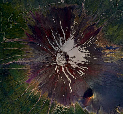
99% (or more) visitors of Fuji prefer the light version: reach the elevation of about 2300 by bus or car and only there start climbing the bare volcanic cone by feet. Car usage near Fuji is restricted, so most of the people ride buses. The biggest bus station can be spotted in the middle of the upper edge of the above satellite photo. This bus station shares the elevation with the 5th station of the Yoshida trail, located 2.5 kilometers in the East direction.
I had two reasons not to choose the light version. First, I don’t like cheating (the bus trip accounts for a half of the elevation gain from the foot of Fuji to its top). Second, I had no acclimatization and so preferred to gain all elevation slowly to avoid symptoms of altitude sickness. So instead I chose to follow the whole Yoshida trail from its start at the elevation 860 to the top. My assessment of the trail was based on this trip report, and appeared to be correct.
The canonical trip to Fuji should culminate at watching the sunrise from the mountaintop, and I decided to follow traditions. Due to my conference schedule, I had only one time slot: to start on Saturday and go back on Sunday. This meant crowds on the upper slopes, but the rim of the Fuji crater is huge enough to accommodate any crowd.
On a clear Saturday morning I boarded shinkansen in Kyoto and changed in Tokyo to a local train to Shinjuku (probably the biggest train/bus station in Tokyo). There I put my suitcase into a locker (yes, I traveled with a suitcase…), hung around for an hour, and took the bus departing at 11:45 to the Fuji area.
(…A Japanese girl sat next to me. To my big surprise, instead of getting lost in her smartphone, she initiated a conversation. Thus I learned that she had graduated from one of the best Tokyo universities in architecture, skied in Chamonix, hiked and skied in Japanese Alps, ran marathons, et cetera. A popular lake under Fuji was the goal of her trip. There she was going to join her friends, and she brought an ukulele with her to play and sing. Finally she apologized that she was about to fall asleep because previous night she had been baking a cake for her friends…)
By that time, the bus ran into heavy traffic – the weather was excellent and the people were running from Tokyo for the weekend – so I arrived in Fujiyoshida town, closest to the trailhead, at 14:15, 40 minutes off the schedule.
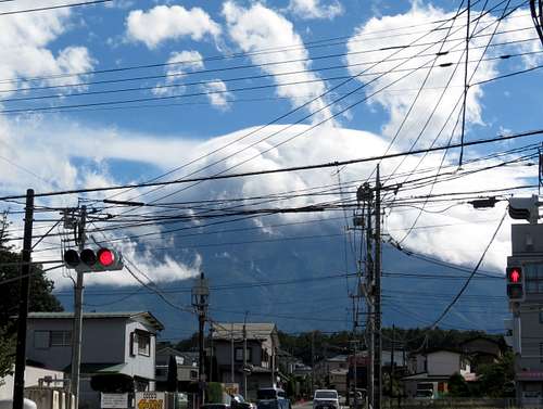
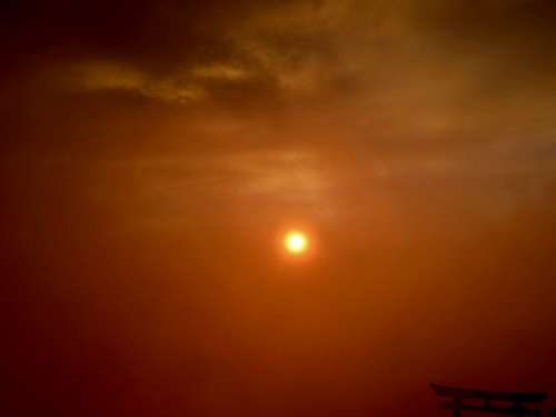
I had a lunch at the lower level of the Fujisan bus station. It was almost 3 p.m. when I finally scrambled out of the cool confines of the station to a hot street of Fujiyoshida and started the hike. The location of Fuji was more than obvious, but the mountain did not want to reveal itself:
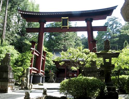
In twenty minutes, I reached a big Shinto shrine in a picturesque grove. The photo presents torii – entry gate – and the biggest of more than a dozen buildings of the shrine. The shrine looks pretty nice but a sunny Saturday meant a bit too much people.
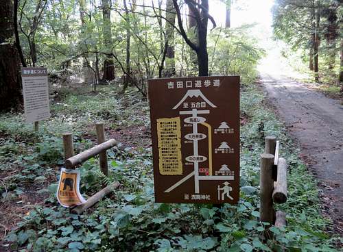
To reach the trailhead, I skirted the main building from the right, passed the torii at the back of the shrine and caught an asphalt road. A hundred meters by asphalt, a turn right to a gravel road – and I stood at the Yoshida trailhead at 15:30.
While I texted a “poyekhali” message to my wife and looked at the “beware a bear” sign, I heard a sudden sound of crashing brushwood. Turning around, I saw not a bear but a young man who asked me in a good English whether I am going to climb Fuji and may he join me because he cannot bear those bear pictures alone. As Rik (the name of the guy) told me on the way, he was from Netherlands, had graduated from a medical school there, and was performing his postgraduate practice in a hospital in Hiroshima.
The trail was wide and ascended very gently, so we walked quite fast. Here and there we saw trees broken or even rooted up by a powerful typhoon, which had run over Honshu several days before, in the day of my arrival to Japan. Our aim was clear: to finish the forest part of the trail before the dark. However, this seemed hardly possible (those forty minutes of the bus delay made the difference).
The forest part of the trail is 16 km long and gains about 1400 meters of elevation; it ends at the 5th station, which is close to the tree line. After two hours of fast walk we crossed the same asphalt road and saw a dozen of cars on a small parking lot nearby. It became clear that some local people go hiking from there; we met a few people going down by the trail. By the way, it was no longer sunny, and some drizzling began: we reached the outskirts of the weather singularity created by Fuji.
Soon after, the trail became much steeper, well marked with signs, and fortified with logs and boulders. At some places it looked more like a stairway with earth stairs supported by logs.
The ascent slowed Rik, and I gave him one of my poles. We overtook a slow moving group; the impression was that a local instructor lead several tourists, some of them European and some Indian. I don’t know what was their destination, because it started to grow dark very soon.
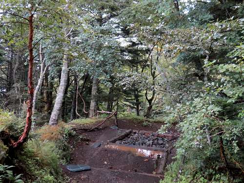
At 18:00, in the twilight, I was waiting Rik near one of the abandoned stations (its unused building was freshly destroyed by the typhoon), and Rik came with a company: we were caught up by another young man – Jean from France, who had just come to Japan for a conference in physics. Jean was faster than we two (he had started at 15:55) but preferred to join because of the coming nightfall. The trail was so good that we reached the 5th station without turning on lights, though the last 40 minutes (we arrived at 19:00) it was already dark in the forest. The station was functioning but looked somewhat declining, especially in the dark: old building, dim light, almost no people.
Both Rik and I read the trip report mentioned above and got the impression that the bus station, where most of the people start the hike, is nearby, and so we were close to the “main” 5th station, with several places to sit and eat. Thus we decided to go there to have dinner. However, the report was quite wrong about this: the actual distance from our location to the bus stop was more than 2.5 km, and we didn’t reach the main station.
The upper half of the Yoshida trail is short (7 km), steep (1.5 km elevation gain) and should be walked slowly, otherwise you will find yourself at the top around midnight and spend several freezing hours until the dawn. The trail presented no technicalities – not above T2, I would say – but it should have been traveled at night.
We put on some clothes since it became a bit chilly due to both the altitude and the nightfall. At 19:30, we started moving with headlamps turned on. At the altitude 2250-2300, the trees still grow but more sparsely. In the gaps, one could see an endless procession of fireflies, slowly moving up the slope of an absolutely black volcano under somewhat annoying drizzle. Unfortunately, the pictures I took appeared to capture only blurred spots of light in the darkness. Soon we reached a fork; the sign “Yoshida 5th station” showed right and down, while the arrow to 6th station directed left and up. We didn’t want to drop the elevation, so we decided to go to 6th station, hoping to find some meal there. The hope didn’t come true: the station (2390) was rather small, with no eateries or other places to sit and warm up. At the station, our trail met the main trail from the bus station and we joined the procession of fireflies (or snails?). Rik bought a wooden pole, which is the main Fuji souvenir. For me, it seems barely suitable as a hiking pole. The aim of buying this piece of wood is to get a collection of burned stamps on it (a unique stamp for each station), which gives you a confirmation of climbing Fuji. Anyway, soon after 8 p.m. we began to move our empty stomachs, as well as our hopes to eat and rest, to the 7th station (2700).
In a book or a movie, we would get nothing at the 7th station as well, and the plot would push us up, towards the mountaintop. The reality was merciful: one of the buildings at 7th station was a mountain hut and contained an eatery inside. Ordering some food gave a guest the right to seat half an hour in a warm room. Our group of three European-looking foreigners drew the attention of John, whose appearance fitted well to his name and reminded of the companion of Robin Hood. Seemingly, John was the chief there. He told us that he had, at that moment, 127 people for overnight stay due to the last weekend of the season (I should say that huts in Alps which can accommodate 127 people look much bigger). He also said that all higher huts are full and gave an advice as to where to go on the rim to avoid a crowd at dawn. Probably by his word we were able to stay in the hut from 21:30 almost to 23:30, adding something to our order from time to time. We still had a plenty of time, assuming reaching the top approximately at 4:15, one hour before the sunrise. Meanwhile, the weather worsened drastically. At the time we were asked to leave the hut to free the place for other people, there was heavy rain outside. The rain was “horizontal”, where the wind just drives thick rain clouds through everything and everybody.
From this point, the difference in equipment became critical. I was prepared to both rain and freezing, while my fellows were not. I had a termal underwear, wooly socks, wooly hat, gloves and a thin polyethylene cloak which covered me with the backpack. When at 00:30 we reached the lowest building of 8th station, I felt warm and comfortable. Feet, lower legs and hands were wet, but that was all. My fellows in “waterproof” jackets apparently felt much worse, not mentioning the fact that Jean was wearing shorts...
Nevertheless, we continued to “snail” up for a while, reaching the elevation of about 3250. From some moment it appeared that while many people continued to go up, some others used the trail to go down. I spotted this but didn’t think what should it mean. However, soon the things were clarified: a man in uniform stood in a small space near one of the next huts and spoke something in Japanese. As Rik had already spent a half an year in Japan, working among Japanese colleagues, we delegated him to listen to the speech. Then he returned and translated the main message: the mountaintop and the 9th station are closed due to weather conditions, so please everyone go down. But if you don’t want to go down, you may stay here and wait for the sunrise. And you even may continue to the next station 8½, because it is still open, and meet sunrise there.
We discussed how the new circumstances affect our plans. I told Rik and Jean that a night descent by a steep and, in places, rocky slope is not a good idea and I would not go down until dawn even if somebody would kick me away from here; and currently I plan to ascend as high as possible. Due to the bad weather and inappropriate clothes, Rik and Jean were not in a mood to follow me. Thus our small group disintegrated into atoms: Jean ran down (he had left his luggage in a locker in the train station below), Rik stayed in place, and I continued to play a snail. (While sitting at 7th station, we had exchanged the phone numbers and Jean later created a group in a messenger. So all of us knew that everyone finished successfully.)
By 2:30 I passed several more buildings, watching a number of brightly coloured backpack covers flying around (the wind strengthened), and reached the 8.5th station (3450). There I met three uniformed persons; they didn’t allow people to go further by the trail which passed by the station building and asked the newcomers to go back. I didn’t want back, so I observed that some people stayed in a row under the cornice of a hut, and nobody was kicking them. I spotted some free space from one side and joined this row. The cornice didn’t help much against the rain but the wall protected us from the wind, so it was almost comfortable to stand. There was still plenty of time until the sunrise, so I kept calm and hoped for some game-changing factor. The idea to climb the upper part of the cone offtrail, at night, and under a heavy rain seemed not attractive enough, and I refused it.
After forty minutes or so I found that only two uniformed persons remained. One of my cornice neighbours passed them, apparently heading for the WC, and didn’t return. Then another one did the same. Then a big young guy, with two heavy white plastic bags but without a light, came from below and ran further (the only explanation occurred to me was that the guy worked at 9th station). I decided that it was my turn, and moved. Nobody stopped me; I passed the station hut and WC. At the turn of the trail I turned around to see whether anybody was running to arrest me. As it appeared, two other people from under the cornice followed me; reacting for my sudden movement, they froze in place, trying to look like a part of the landscape. I turned from them and concentrated on the trail. It seemed that the unpleasant wind blew from all directions; probably it was just swirling around the mountain. Several times I stopped and put the full weight on poles to resist the wind gusts. Other than that, everything went smoothly: there were nobody outside the 9th station (3580), and at 4:15, as was planned , I passed the torii in the end of the trail and stepped on the rim. Torii always means a shrine behind them; this one looked like yet another closed hut. A few meters further, two little canary-yellow bulldozers were parked…
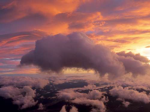
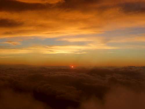
On the rim, there were about fifteen hikers (which looked like 1% of those remained on our slope), busy with insulation and warming of themselves. Some of them had “silver” blankets, somebody even brought a tent; however, the tent can be used only as a blanket, because neither the wind nor the rain weakened. I followed suit, because it was cold and I had one more layer to put on. But to put it on, I first needed to pull my polyethylene cloak off. At the moment I did this, a sudden wind gust snatched it from me, and the cloak flew off down the slope, waving sleeves like wings. So in the next half an hour I got wet though I squeezed myself into the corner under the cornice of the hut. But at 4:45 the rain stopped: now the wind just dragged thick clowds over our heads. At the same time, the darkness changed to the morning twilight. I left my refuge and tried to make pictures. It was quite hard: the lens became wet in a couple of seconds, so I needed to dry them almost non-stop. As a result, the number of decent pictures is minimal. However, the situation became better just before the sunrise (5:15): the clouds were still dragged over our heads but with reasonable time gaps. The population of the rim increased to fifty or even sixty people just before the sunrise: perhaps those who stayed at the 9th station were allowed to the top.
The sunrise on Fuji is a magic beyond words.
Finishing with the pictures of sunrise, I decided to walk around. There is a circular trail around the rim, which also climbs its highest point (3776; the elevation of the point where I stood was about 3740-3750). First I went to the edge of the crater, trying to look inside. Inside there was a cloud, so nothing else could be seen. The wind was so strong that even the poles could not help to stand on a horizontal surface against the gusts. I walked about 150 meters along the trail, hiding from the wind behind rock fragments. But the next, completely open, passage ran by the very edge of the rim. An attempt to pass there resembled Russian roulette: either you would catch a gust while moving or you wouldn’t. I preferred to turn back. However, I saw two Japanese men who went there – may be they never heard about Russian roulette.
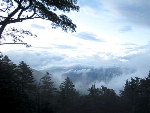
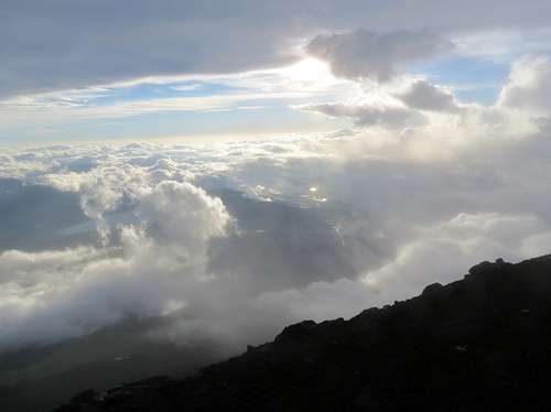
The descent was not so fascinating as the ascent. However, sometimes gaps appeared in the clouds, and something interesting could be seen:
In the upper part of the Yoshida trail, the trails for ascent and descent are separated. The descent trail is a wide serpentine with a relatively small incline; it is actually a road (that is how the bulldozers reached the top).
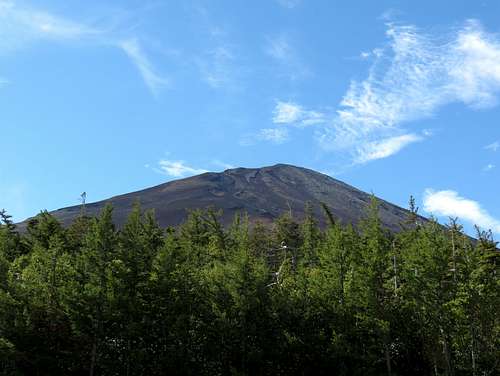
I started the descent approximately at 6:30, and at 9:00 already reached the bus station (I saw no reason to descend back to Fujiyoshida and bought a ticket from the station on the mountain). I should say that the last half an hour, when the elevation was already dropped and a straight way to the bus station remained ahead, was really hard. Every minute my body told me that it is a very good time to lay down on the roadside and sleep a bit. However, the automatic pilot somehow managed to drive me to the finish. At the altitude of 2300 it was sunny and nearly hot. I am not sure what was at the top at that moment: I suppose that this picture does not show the top...
I fought with sleep for another hour, boarded my bus and went back to Tokyo. As a revenge, my mind and body refused to sleep in the bus.