
-
 27112 Hits
-
 91.74% Score
-
 36 Votes
|
|
Route |
|---|---|
|
|
38.00330°N / 107.792°W |
|
|
Mountaineering |
|
|
Spring, Summer |
|
|
Most of a day |
|
|
Overview
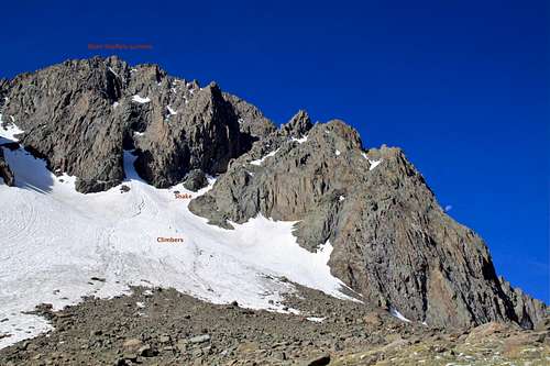
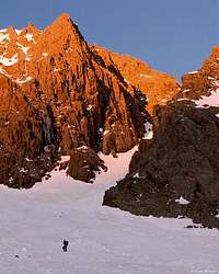
Snake Couloir is located on the north side of Mount Sneffels.
When snow conditions are good, this is one of the best mountaineering routes on Colorado Fourteeners. When snow conditions are bad, or after the snow melts, avoid this couloir. The confined couloir acts as a funnel for falling debris, and this famous route has produced epic accidents. (I had a close encounter with a rock while soloing, and you don't want to take a fall here).
The Snake Couloir is westernmost of the three major couloirs on Sneffels north face. The deeply inset Snake Couloir is well named because it snakes up through the heart of the complex north face.
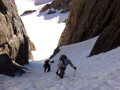
 Snake on the approach with some climbers Snake on the approach with some climbers |
 Approaching the turn in the Snake Couloir Approaching the turn in the Snake Couloir |
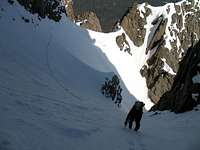
The bottom of the Snake Couloir faces northeast, and the upper part faces northwest. Because of the turn in the couloir, there is no single vantage point that allows you to see the entire couloir. You can see the upper part of the couloir from Colorado 62 west of Ridgeway, but the lower part is hidden. You can see the lower part of the couloir from Blaine Basin, but the upper part is hidden. The snow in this natural avalanche chute gradually turns to ice as summer progresses.
The best approach is from Blaine Basin, but you can also drop in from Yankee Boy Basin. Blaine Basin approach is classic, longer, scenic. Yankee Boy Basin approach is shorter and there can be a lot of traffic on Camp Bird road in the summer.
The best time to climb this couloir is from May to July. As the summer progresses the snow hardens and the couloir becomes more icy. This couloir is also skiable earlier in the season (May) when there is snow, but be aware that in the winter this is an avalanche chute.
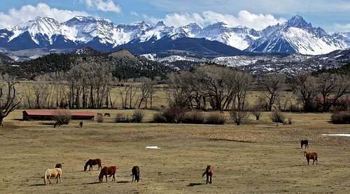
Mount Sneffels is one of my favorite fourteeners. The views of Sneffels from highway between Ridgeway and Dallas Divide are renowned and when the aspens change color in the fall, this panorama represents Colorado.
 Mount Sneffels scenery Mount Sneffels scenery |
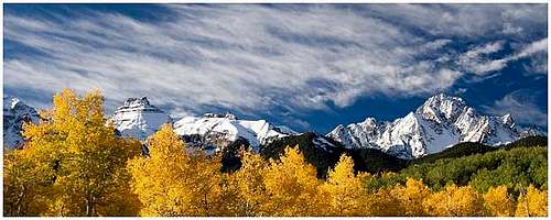 Mount Sneffels in the fall Mount Sneffels in the fall |
Sneffels name as been a source of contention for years. Some believe that the name is from Jules Verne's book Journey to the Centre of the Earth. In this book, Verne refers to a volcanic mountain in Iceland, known as "Snaefellsjokull", as the gateway to the center of our planet. Most of us had no idea how to pronounce it, and it became "Sneffels". Other rumors persist that a "Mr. Sneffels" existed. A third explanation is that miners who worked on the mountain called it "Mount Sniffels", due to the cold-induced conditions of the chilly tunnels.
Getting There

Snake Couloir as seen from Blaine Basin
Mount Sneffels is located 7 miles west of Ouray and 5 miles north of Telluride.
East Dallas Creek Trailhead 9,340 feet This trailhead provides access to Sneffels north side. Go west on Colorado 62 for 4.8 miles from the US 550-Colorado 62 junction in Ridgway. Turn south onto Ouray County 7, well-marked East Dallas Creek Road. Follow this well-kept dirt road for 9 miles until it ends at the Trailhead. It is about 9 miles long and the views of Mount Sneffels from here are superb. You don't need high clearance or 4WD vehicle for this road. It is well kept during the summer. The road closes in the winter (only the first part is open for private residencies - many people living there have to use snowmobiles in the winter to get in and out).
There is plenty of camping at the trailhead and a nice creek. This is also a trailhead for Blue Lakes.
Blaine Basin Approach - this approach gives access to all the routes on Sneffels north and east sides. Start at the East Dallas Creek Trailhead at 9,340 feet and go straight at the trail junction just south of the road closure gate onto the Blaine Basin trail (the trail is well marked with frequent signs). You will have to cross several creeks - East Dallas Creek and Wilson Creek higher up. There are log bridges across the creeks. You will reach Blaine Basin at 10,740 feet after about 3.2 miles hiking from the trailhead. It is still over 1 mile to reach the base of the Snake from here.
Many people like to camp in the Blaine Basin - the views are spectacular and the wildflowers in the summer are amazing! There are no camping restrictions, and there are many creeks, grassy areas and trees, which allow secluded camping. You can cross into the Yankee Boy basin, either by ascending into the Lavender Col (between Mount Sneffels and Kismet), or by ascending into the Dyke Col (between Kismet and Cirque) if you are into backpacking trips. Blaine Basin is more quiet compared to Yankee Boy basin, which is full of motorized vehicles in the summer. Blaine Basin is a popular destination for day hikers too.
Please see other routes for descriptions to Yankee Boy Trailhead. I would like to note that you can drive to a high parking lot at 12,440 feet if you have a high clearance 4WD vehicle. You would have to ascend into the Lavender Col at 13,500 feet, drop down either into the Blaine Basin - long way around to get to the Snake, or head westward from Lavender Col and cross into the southeast couloir and down climb, which will take you just below the north face of Sneffels. You have to traverse steeper snow slopes to enter the Snake. Again, if you don't know the mountain, it may be harder to find the Snake this way. (A friend of mine climbed the Central Couloir when going this way by mistake. And central couloir changes into a dry tooling higher up:)
 Mount Sneffels in the fall from East Dallas Road Mount Sneffels in the fall from East Dallas Road |
 Mount Sneffels from East Dallas Creek Road Mount Sneffels from East Dallas Creek Road |
 Well marked trail Well marked trail |
 Mt. Sneffels TOPO Mt. Sneffels TOPO |
 Waterfall along the trail Waterfall along the trail |
 3 miles in 3 miles in |
 Higher up in Blaine Basin Higher up in Blaine Basin |
 Nice trail lined with wildflowers Nice trail lined with wildflowers |
 Many creek crossings Many creek crossings |
 Blaine Basin lower section Blaine Basin lower section |
 Blaine Basin Blaine Basin |
 Trail in the upper section of Blaine Basin Trail in the upper section of Blaine Basin |
Route Description
From East Dallas Trailhead - 9.9 miles round trip, 4,810 feet elevation gain.
Use the Blaine Basin approach. From the bench at 11,000 feet above Blaine Basin, hike 0.9 miles southwest toward the center of the north face and enter the couloir at 13,000 feet. Be aware of rocks falling from above (especially dangerous if they are climbers above you). The route is pretty obvious and you can see the Snake from your approach.
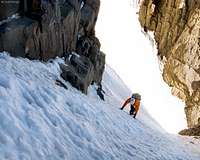
The average angle of the couloir is 40 degrees, but the angle is not consistent. The steepest portion of the couloir is 200 feet below the turn in the couloir at 13,550 feet. The angle here reaches 50 degrees. (This is where I lost my glove and watched it sliding all the way down. Luckily, had another pair of gloves.).
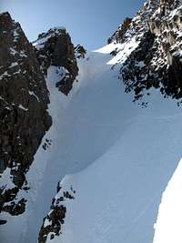
After the turn, the couloir gradually becomes less inset until it ends below a cliff leading directly to the summit.
I chose to climb directly up, which was rather fun in crampons, about 5.5-5.6 rock and a fall would be fatal (all the way down the Snake). The direct climb finishes right at the main summit.
There is an easier way to finish your climb. Angle left and do an ascending traverse east to reach a small 14,060 foot notch just west and above the 14,020 foot notch at the top of the couloir on the South Slopes. Finally, scamper 150 feet to the summit.
 Climbers entering into the Snake Climbers entering into the Snake |
 Snake in the morning light Snake in the morning light |
 Snake start Snake start |
 Entry to Snake - view down Entry to Snake - view down |
 Climber inside the Snake Climber inside the Snake |
 Splattski Splattski |
 Sarah Thompson in the Snake Sarah Thompson in the Snake |
 Steeper section Steeper section |
 At the bend At the bend |
 View up from the bend View up from the bend |
 Above the bend Above the bend |
 Top of Snake - view down Top of Snake - view down |
 The main summit The main summit |
 Award on the top Award on the top |
 Blue lakes as seen from the summit Blue lakes as seen from the summit |
Descent It is well known that the summit is only a half point, and most accidents happen on the way down. As I mentioned some people ski Snake couloir, but they usually climb it different way (just to keep all options, you can rap down to the top of the Snake, very short rappel, 50 meter rope sufficient), and ski it if you carried your ski gear with you.
Most people descent via South Slopes - see Lavender Col Standard Route. This is the easiest route up and down Mount Sneffels. If there is a lot of snow in the deep couloir (as was my case), descend via South Slope variation, and then drop into the Lavender Col. From the Lavender Col you have to descend steep scree into the Blaine Basin. You will end up at a different place than your start (don't leave any gear/backpacks at the start of the Snake). Most likely the scree section will be only at the top section of the slopes. I found snow slopes, which usually stay here till end of June, and was able to glissade most of my way into the Blaine Basin. Join the trail leading back to the trailhead at East Dallas Creek.
 Descent South Slopes Descent South Slopes |
 Into Lavender Col Into Lavender Col |
 13ers in the area 13ers in the area |
 Glissade |
 Down in Blaine Basin Down in Blaine Basin |
Essential Gear
Comfortable crampon compatible boots, crampons, one mountaineering axe.
Many parties rope up and carry some rock gear - useful at the top of the couloir to finish right at the summit - mid 5th class moves. I did solo it and did not find it too challenging or steep, the biggest danger for me was being hit by a rock and losing my balance because of it. A fall on this route would lead to a long and fast slide down the couloir with cliffs and rocks along - don't want to even imagine. Use your own judgment and don't take a fall.
Sunblock, water, warm closing, headlamp etc.
And don't forget your camera! It is very photographic up there :)
External Links
You Tube video with approach, climb etc.
Skiing Snake on 14ers.com
Hot springs soak after your climb
Recommended dinner place in Ridgway good beer and excellent pizza, cheap too