
-
 7429 Hits
-
 89.01% Score
-
 28 Votes
|
|
Route |
|---|---|
|
|
38.00330°N / 107.792°W |
|
|
Hiking, Mountaineering, Scrambling |
|
|
Spring, Summer, Fall, Winter |
|
|
Half a day |
|
|
Class 3 |
|
|
Overview
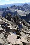
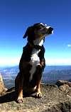
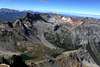
This is a variation of the South Slopes route described in most Colorado Fourteeners books and on the web, Class 2+ route via Lavender Col. The route starts from Yankee Boy Trailhead, and the first part up is up to a scree Col = Lavender Col at 13,500 feet, which is the saddle between Sneffels and Kismet. (Lavender is named after a man, no lavender growing there). The first part is the same as the Lavender Col route.You start up scrambling the deep couloir for about 20 meters, and then climb out of the couloir on its southern side, to your left. There is a little path, occasionally marked with a small cairn. You basically climb up and above the deep couloir all the way, on its southern side, and straight up the face. It is mostly class 2-3 scramble. My 11 year old dog Duchess had no problems (only 1 lifting en route - but she moves like a mountain goat). You have to use some route finding skills, but I found this route more comfortable than climbing through the loose rock inside the deep couloir.
Basically, the most difficult part is to find out the right spot where to exit from the deep couloir onto southern Mt. Sneffel's face, and it is also technically the most difficult section.

SP route descriptions - it would be located between the Lavender Col route and the "Birthday Chutes".
Getting There

The road to Yankee Boy Basin is a very popular road, the first part of the road is well kept, the higher sections require a high clearance 4WD.
Start on US 550, go less than 0.5 miles south past Ouray, then turn onto Ouray County road 361 (same as for the ice park). Follow Ouray County 361 as it turns and climbs steeply up. The road is spectacular, blasted in some sections by miners, and creating a half tunnel. 4WD high clearance vehicles can make it up the rough road all the way to 12,300 feet!
Most people choose to park way below since the last section of the road gets pretty rough.
There are many parking spots along the route. Low clearance vehicles usually have no problem to make it to a small parking area near the toilet (place where you would start your climb for Potosi, Coffee pot, and Teakettle). Only high clearance vehicles should continue past the toilet.
Route Description
Start at the Trailhead for Blue Lakes, there are signs for Mount Sneffels, and the Lavender = Scree Col is very obvious from this area, as well as the beautiful spires of the Southwest Ridge up Sneffels. Follow the trail up the Col until you finally reach the saddle between Sneffels and Kismet, this is 13,500 feet high. The slope leading up to the saddle is covered with talus and dirt alleys. Stay on the large talus, because the dirt alleys are eroding under too many boots.
 |
 |
 |
 |
 |
 |
Enter the deep obvious couloir, and after about 20 meters look to your left (south). There should be a place where you can scramble above the couloir, and continue your route above the couloir.
The climb is on the face of Mount Sneffels, south of the deep couloir. There are small cairn here and there, many little pathways, and the hike/scramble is more comfortable compared to the negotiation of big boulders and loose rock inside the deep couloir. My dog loved this climb more (she has done deep couloir twice before).
Route finding did not seem difficult, plenty of options, and the summit came to our vision very quickly. I did not time it, but about 1/2 hr from the saddle. (but I tend to move fast in the mountains).
 |
 |
 |
 |
|
 |
 |
 |
 |
Pay attention on the descent - you have to remember where to descent back into the deep couloir. You cannot continue climbing down the face of Sneffels, there will be a cliff. You have to get back to the deep couloir, about 20 meters above its start.
Essential Gear
Good hiking boots (higher ankle covering boots are better to avoid rocks and pebbles inside), small gaiters may be useful, and happy attitude. I don't usually need trekking poles, but could be useful, especially on down hill. No rope necessary.Weather

Additional information
I am not aware of any book or internet site describing this route. I was told about this route by Michael Covington, who has climbed Sneffels more than 100x. Thank you, Michael.Roach's Colorado Fourteeners mentions some variation, where you exit the couloir about 1/3 of the way up the couloir (I remember looking at a spot where it was possible to drop into the couloir), so again slightly different. Don't we love mountains just for this reason - so many different ways up!