
|
|
Area/Range |
|---|---|
|
|
43.43497°N / 113.54095°W |
|
|
Overview
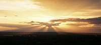 Sunset on the Snake River Plain
The Snake River Plain is the the dominating feature of southern Idaho south of the high central ranges of Idaho. The state's most populated areas lie within this broad valley, and most of Idaho's first impressions are made here. Many of Idaho's cities and interstate highways lie close to the Snake River on the southern side of the Plain.
Mountain ranges south of the plain, part of the Basin and Range province, tend to be more gentle and lower in altitude. The only Idaho peak south of the Snake River that reaches over 10,000 feet is Cache Peak in the Albion Range.
The mountainous areas to the north of the Plain are sparsely populated and are largely undiscovered. Insulated from the masses by large tracts of volcanic desert, the abundance of wilderness and rugged mountains is magnified by the lack of visitors.
In addition, the high desert of the Snake River Plain is also a virtually untouched wilderness, with few roads and hundreds of square miles of both protected and de facto backcountry areas.
 The Upper Snake River Valley Panorama
Climbing
 Snake River Canyon
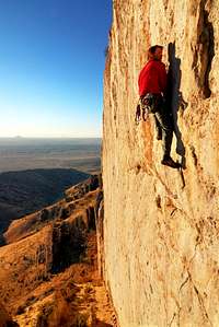
Learn about some great ice climbing areas in and article from Alpinist.
Red Tape
 Area Map
The Great Rift area is managed by the newly expanded Craters of the Moon National Monument
The central section of the eastern Snake River Plain is occupied by the Idaho National Laboratory and is closed to public access. This provides a large protected area for wildlife and leaves most of the desert in a pristine condition.
The areas surround the Snake River Canyon south of Boise and Mountain home is administered by the The Snake River Birds of Prey National Conservation Area, which is also run by the BLM.
Geology
 Yellowstone Hotspot Track
Geologically, the modern Snake River Plain is best known for younger lava fields that now cover the area. These are not related to the Yellowstone Hotspot. They are actually caused by the expansion of the crust as the Basin and Range province expands to the north. The Great Rift, the youngest lava flow and location of Craters of the Moon, was created by this expansion.
The Western Snake River Plain, the location of the Boise metropolitan area and the Treasure Valley, is also a wide valley of the Basin and Range. The valley was filled by rholite ash and other lava flows. The Owyhee Mountains is a part of the Idaho Batholith that has been seperated by this fault block movement and covered in rhyolite from ancient volcanoes of the Yellowstone Hotspot.
Resources:
 Roadside Geology of Idaho and Regional Geology of Eastern Idaho and Western Wyoming are two books with great information about the varied and fascinating geology of the Snake River Plain.
Baarb - Aug 15, 2009 1:26 am - Hasn't voted
I thinkthe geology section could do with some work. For example, mantle plumes are typically considered the source for hotspots, not meteorites.
Baarb - Aug 21, 2009 11:20 pm - Hasn't voted
PanoramaAlso I reckon the 'The Upper Snake River Valley Panorama' picture on the main page would work really nicely as a sliding panorama.