Planning
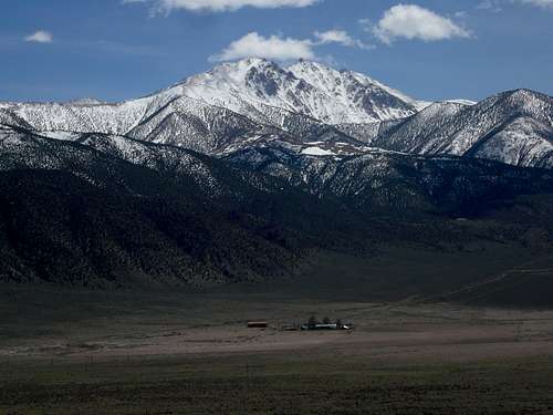
Since I was going to be working in Fallon, Nevada for several weeks, I decided to find some mountains to climb. In 2007 I had attempted to summit Boundary Peak, Nevada with a partner. We were forced to turn back 700 feet from the summit. So this mountain was at the top of the list. I put a plan together and decided I would spend three days and try to summit both Boundary Peak 13,140 feet, and also Montgomery Peak 13,441 feet just over the state line in California. I put together my 40 pound overnight ascent pack. The weather was calling for partly sunny, temperatures; high 20 and lows 1, with 40 mph winds, and minus 20-30 wind chills. I would leave early on Friday and return Sunday. I ended up getting a late start on Friday since I had to wait for a piece of gear to arrive in the mail. I got on the road for the long drive south around 7:00am.
DAY ONE, Ascent to Base Camp
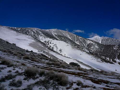
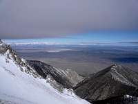
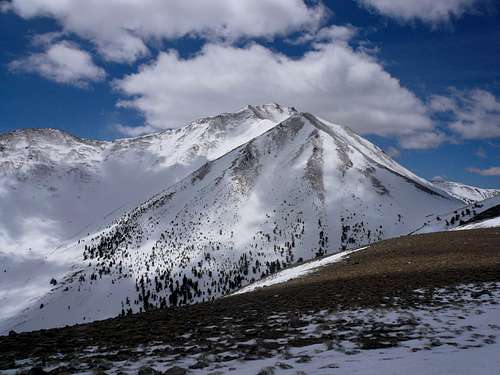
I arrived at 9000 feet in the Queen Mine Canyon and parked. This is the point where the snowpack covered the road to deeply to drive through. I put on my pack and headed up the steep ridge at about 9:40am. The road does keep going through a series of switchbacks up to about 9500 feet or so. I took a more direct route up and over the first steep ridge. On the other side I was back on the snow packed road. This is just an old and rutted gravel road when not covered in snow. I followed it for a ways and then headed straight up the next ridge. This ridge gains about 1,500 feet. The slope was snow covered, and rocky. Wearing double mountaineering boots made for a slow go. The month or so prior to this climb I had been lazy and was now paying for it, suffering some altitude effects. Along the slope there are many very old trees. On a previous attempt here I had seen several wild horses. As I finally top out on the ridge, I could now see Boundary Peak. It was an awesome sight with its massive snow covered slopes and rock outcroppings. The weather on the way up was mostly cloudy with a few flurries. As I made my way along the top of the ridge the weather began to clear out. The winds were blowing at about 20 mph. The top of the ridgeline is made up of spotty trail, deep snow, and rocks. After traversing the ridgeline for about 1.5 miles, I now descend to the saddle between the ridgeline and the base of Boundary Peak. This is where I will make camp. The saddle is covered in about 6 -12 inches of hard packed snow. I arrive at my base camp location at 12:25pm. The route from where I parked to my base camp location is about 3.15 miles. I pitch and stake down my tent and then build two snow walls on the south and west side. The rest of the afternoon was spent resting and refueling. The weather is now mostly sunny, somewhat mild, and windy. The winds are coming from the southwest. From my base camp you can't see Boundary Peak's summit. It is blocked by the lower ridgeline leading up to it.
![BOUNDARY PEAK CLIMB]()
![BOUNDARY PEAK CLIMB]()
DAY TWO, Ascent to Boundary Peak's Summit
![BOUNDARY PEAK CLIMB]()
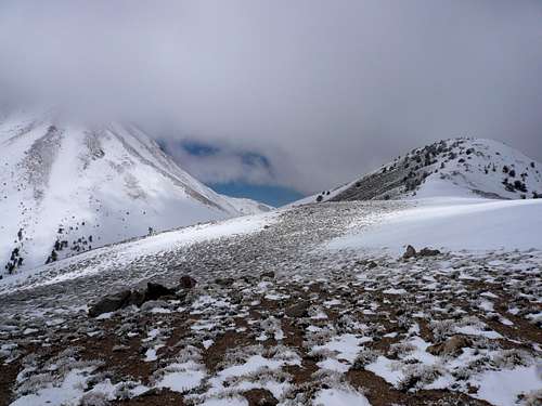
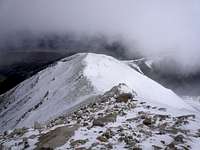
I woke up around 5:30am. The winds all night seemed to be increasing. I actually got chilled in my new minus 25 sleeping bag. I notice the wind has now changed direction and is coming out of a more westerly direction. I find this interesting. I melt some snow to make breakfast and fill my nalgene bottle before heading out around 6:15am. The first task is to climb the steep 1000 feet to the top of the first ridge. The slope does have a switch back trail that makes its way through the loose rocks and boulders. However, with all of the snow, most of the trail was not visible. Once at the top of this you have a full view again of Boundary Peak's summit. The weather is sunny in all directions, but the winds are now blowing strong, approximately 40 mph. The wind chill is sub-zero, later estimated via local weather data to be minus 30 to minus 35. The next traverse is a long, steep, and exposed ridgeline to the summit. The snow is blowing up off the ridgeline and creating a bit of a ground blizzard. As I ascend I noticed what appears to be a small lenticular cloud forming on the southeast side of the summit. I now realized that the weather may be changing dramatically from what was forecasted. this makes me a little nervous. This cloud formation starts at about 7:15am. I continue to ascend the steep, snow and boulder covered slopes. The cloud now begins to grow rapidly. The wind is still blowing up snow over the ridge. I don't get right up on top of the ridge, but instead traverse the slope below.
![BOUNDARY PEAK CLIMB]()
![BOUNDARY PEAK CLIMB]()
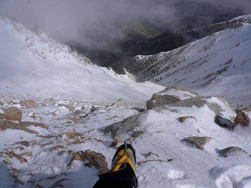
The fall hazard here is tremendous. I slip here would send a person sliding 1000 feet or more if they were unable to self-arrest. The lenticular cloud continues to grow. It now stretches a good ten miles in all direction, and I see it churning. At 8:05am the cloud has descended onto the top 1000 feet of the mountain. So within a span of 50 minutes the tiny lenticular cloud turned into a raging localized storm system. The wind is 50 - 60 mph at this point and the visibility is only a couple hundred feet. I have to admit, this is one of the more amazing weather moments I have witnessed. The altitude is also really kicking my butt at this point. I'm giving it everything I have to ascend. Fighting blasting winds and blowing snow. I have on all of my layers at this point. The final 300 feet was brutal. I was only able to take a few steps at a time and then having to rest. It felt like I would never reach the summit. I finally reach the summit at about 10:15am, snap a few photos of myself, and decide to quickly descend. There is no view since the lenticular cloud is raging around the summit.
![BOUNDARY PEAK CLIMB]()
![BOUNDARY PEAK CLIMB]()
![BOUNDARY PEAK CLIMB]()
![BOUNDARY PEAK CLIMB]()
![BOUNDARY PEAK CLIMB]()
![BOUNDARY PEAK CLIMB]()
![BOUNDARY PEAK CLIMB]()
DAY TWO, The Descent
![BOUNDARY PEAK CLIMB]()
I worked my way back along the steep slopes. For some reason on this climb I had real trouble with the effects of altitude. Likely because I got a little out of shape prior to doing it. I even took several anti-nausea pills on the way up. When I get back down to about 12,000 feet, the lenticular cloud begins to dissipate as fast as it formed. Within about 30 minutes it is nearly gone. The wind was still blowing around 40 -50 mph, but the temperature is rising. I arrive at base camp at around 11:45am. I had planned to leave on Sunday, but with the appearance of the lenticular cloud, and now some high clouds, I decide to pack up and get out. I get all packed up and begin descending around 12:30pm. This was an exciting challenge packing up in strong winds. I work my way back along the ridge. The sun is shining and the temperature has risen significantly. My body is dead tired, and is ready to crash. I reach the small ridge above my car after what felt like an eternity, and decide to glissade down the final couple hundred feet. I reach my car, unload my gear, and drive off.
![BOUNDARY PEAK CLIMB]()
Climb Details
DATES: 30 apr 2010 - 01 may 2010
TOTAL MILES: 8.7
TOTAL TIME ASCENDING: 6 hrs
TOTAL TIME DESCENDING: 3 hrs
TOTAL ELEVATION GAIN: 7065 feet
PACK WEIGHT: 40 lbs
WEATHER CONDITIONS: Sunny, Lenticular Cloud, Blowing Snow, Flurries
AIR TEMPERATURE RANGE: 0 - 46 Degrees Fahrenheit.
WIND SPEEDS: 20 mph - 60 mph
COLDEST WINDCHILLS: minus 30 - minus 35
TERRAIN: Steep Snow, Ice, Rocks.


Comments
Post a Comment