The Boys Take a Climbing Trip
Frank, Steve, and John had an Eastern Sierra adventure from July 16-22. Plans got firmed up in April when we obtained a permit through the lottery to climb Mount Whitney on July 20. Steve and I both flew into Las Vegas on July 16th. Steve's flight from Spokane via Salt Lake was on-time, as was mine. After renting a Dodge Journey SUV, we escaped town as quickly as possible and headed north on US 95. We had a pleasant drive through the desert. We hit a few major cloudbursts from thunderstorms. The journey turned left on NV266, crossing over to CA168 over Lida Summit, Gilbert Pass, and Westgard Pass. The road was deserted and our first views of the snow-capped Sierra Nevada were exciting. We arrived in Bishop, CA at 8 PM, after an easy 5-hour drive. Our lodging for the next three nights would be the Bishop Holiday Inn Express. After a late supper al fresco at Whiskey Creek, we called it a night.
Mono Pass - Yosemite National Park
Steve and I arose early Saturday and headed up US395 past Mammoth Lakes to CA120 over Tioga Pass. This is the high eastern entrance to Yosemite National Park. The road had just opened for the summer a month prior. We chose the Mono Pass trail as a warm-up and acclimatization hike. The trailhead is at 9600 feet. We enjoyed a leisurely 7.5-mile round trip hike past and through a few streams, through alpine meadows, to the 10,600-foot Mono Pass. We spied a mule deer across one of the meadows. The trail was popular. Along the way we enjoyed viewing some Lodgepole pines many times more massive than those we were familiar with from the northern Rockies. It was pleasant in the mountains, perhaps low 70s F with low humidity.
![Mono Pass Trail]()
We returned to the car in time for the 1.5-hour drive back to Bishop to rendezvous with John by 3 PM. His drive up from Oceanside was uneventful. The temperature back in Bishop, in the Owens Valley, was at least 105F with a dry hot wind blowing. This scenario would great us pretty much every day as we returned from hiking. Pleasant in the mountains at altitude...really hot in town. After provisioning at Joseph's Bi-Rite grocery, we had a really good dinner at Jack's Restaurant. The NY strip steak was tasty and reasonable. Anticipating a big day ahead, we turned in early. Active days and tired short evenings were the norm for the whole trip!
Boundary Peak - The Top of Nevada
At 13,140 feet, Boundary Peak is the highest point in the state of Nevada. It is located at the northern end of the White Mountains about 50 miles NE of Bishop. Our first objective on Sunday morning was to find the start of the Queen Mine Route up the mountain. This is reached by a 6.2-mile unimproved dirt road south of US6. What a remote section of mountains! There is no sign to indicate the turn-off. I was surprised and pleased that our group had the entire mountain to ourselves the whole day long! This would be sharply contrasted on Mt. Whitney a few days later.
The Dodge Journey did an adequate job getting up the road. It would be a stretch to say that most passenger cars could make it. We reached a large flat at the abandoned Queen Canyon Mine at 9200 feet and parked. We left the car at 8 AM. The road got rougher and continued for perhaps 1 1/4 miles more to a saddle at 9700 feet. A well-worn but unmarked path led south from here, climbing to a long flat-topped ridge. There were lots of wildflowers blooming. Once we gained the ridge the actual summit of Boundary came into view. This looked like it was going to be fun! We reached the Trail Canyon Saddle, at about 10,800 feet, and took a breather before starting the steep climb.
The herd path continued up from the saddle through some fairly loose scree. It was easy to follow until about 1,000 vertical feet below the summit. The climb then required a bit of route-finding, and everyone did fine. The most difficult part of the route was no harder than a class 2 climb. I made the summit at high noon, and Steve and John followed a short time later. Views from the top of Nevada were striking. We could see probably 100 miles in most directions. The temperature was in the 60s with a light breeze blowing.
We found a couple of interesting surprises in the summit register box. One was a Boundary Peak banner. Of course, we unrolled this and posed with it for a timed group shot. Another surprise was a small monument to a retired Nevada patrolman who had just passed away in April. After spending some quality time on top, we slipped and slid back down the scree slope to the saddle.
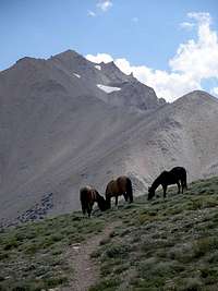
Our neatest wildlife experience of the entire trip awaited as we hiked back across the long ridge. We came across a small crest and almost walked right into a herd of eight wild horses. Our first impression was that they seemed really tame for wild horses. We quickly surmised that they weren't tame; they just viewed us as absolutely no threat. The lead stallion stood in the trail, facing us, put his head down slightly, and glared at us. We all immediately got the message and detoured off the trail. This was a fantastic photo opp. as we got within about 50 feet of the horses.
We continued downward and arrived back at the car just before 4:30 PM. We estimated the round trip distance to be close to 12 miles. Except for our vehicle the parking area was still deserted, and we saw no one on the drive back out to the highway.
Sunday's dinner selection in Bishop was Amigos Mexican Restaurant, which unfortunately was too authentic Mexican food for Steve. He ate a bad tostada and had to pay for it the next few days. Luckily Steve is one tough trooper and did not let the unpleasantries of bad Mexican food ruin any of his outdoor adventures.
Horseshoe Meadows - Cottonwood Lakes
On Monday morning we checked out of the Holiday Inn Express and headed south one hour to the town of Lone Pine. We checked in at the Interagency Visitor Center to obtain our Whitney climbing permit, instructions, and "WAG bags". For the uninitiated, Whitney is such a popular destination that the USFS now requires people to pack out both their garbage and their poop. It's not a bad thing.
We planned to start hiking in the dark the next morning. We drove the 13-mile paved road to Whitney Portal and the trailhead to check things out. This rises from 3,700 to 8,600 feet elevation. We did some exploring around the trailhead and campground, checked out an awesome waterfall, and met Doug at the Whitney Portal Store. After enjoying lunch at the store we desired a relatively flat hiking destination to get the kinks out of our legs before the big day tomorrow. We drove back down to the valley, then immediately back up the Horseshoe Meadows Road. These paved roads are truly engineering miracles, as are many of the hiking trails. This road climbs massive switchbacks over 15 miles to reach the trailhead at 10,000 feet. We then hiked about 5 miles roundtrip up the Cottonwood Lakes trail. It was a pleasant and easy hike. We didn't go in far enough to reach the lakes (by design) but had fun viewing the unique lay of the land and hiking along the stream.
Upon our return to Lone Pine we checked in to the Comfort Inn, cleaned up, and then enjoyed pre-event carbo. loading at the Pizza Factory. The pizza was good and the loopy counter attendant was certainly entertaining if not helpful.
Mount Whitney - The Mother of All Day Hikes
I anticipated the alarm and awoke at 2:45 AM on Tuesday morning. Mount Whitney has summit elevations reported between 14,494 and 14,505 feet. Due to plate tectonics the Sierras are still growing in height. No one disputes it as the highest point in the contiguous 48 states, and thus its popularity as a hiking / climbing destination. The class 1 hiking trail is 22.4 miles round trip and has a total elevation change of about 6,400 vertical feet. The trail is remarkably well constructed for traversing such extreme country. The USFS awards 100 day and 60 overnight permits daily during the popular summer season. We thought most rational people would choose the overnight hike. Those that attempted this as a day hike were either quite fit (we counted ourselves in this category) or delusional. Unfortunately we encountered many day hikers along the trail that just had no business attempting a trip of this magnitude. I think that the easy access that the trail provides gives a false sense of security to folks that are either not in shape or not used to being at such high altitude.
We turned on our headlamps and left the trailhead at 4:15 AM. Several other parties heeded the advice for an early start. We could see headlamps winding up the switchbacks ahead of us. The first four miles of trail were a gradual, pleasant climb. By 5 AM dawn was starting and I turned off my light. It was a strikingly clear day and a beautiful sunrise. The east-facing cliffs above us reflected the sun's morning rays. Temperatures were in the 50s.
After two hours we reached Outpost Camp at about 10,000 feet elevation. We then started climbing the next 2.2 miles and 2,000 feet up into the Alpine Zone to reach Trail Camp. Waterfalls and cascades disappeared and reappeared under snowfields. Running water was everywhere. The scenery was amazing. Trail Camp is where most people who overnight make their high camp. The eastern face of the Whitney massif is a sheer 2,000-3,000 feet of vertical rock. Luckily, the trail builders provided access for us by a series of 97 switchbacks south of the cliffs and up gentler slopes. Before ascending the switchbacks we were amused by a family of marmots begging for food and providing good photo opportunities.
![Whitney Trail]()
![Trail Crest View]()
The trail up the switchbacks had only been clear of snow for a couple of weeks prior to our hike. Prior to early July, summiting involved a technical climb up the snowfield to the north involving ice axes and crampons. About a quarter way up the switchbacks was an excellent spring, which we took advantage of to drink deeply and re-fill our water bottles. This was the last dependable water below the summit. We crossed the fabled cable section and finally arrived at Trail Crest. This point, 8.7 miles and 13,700 feet, is where one finally crests the summit ridge and gets the first western view into Sequoia National Park. It was spectacular. Trail Crest had a moderate breeze blowing and was a bit chilly.
![Whitney Trail - Above Trail Crest]()
![Whitney Summit]()
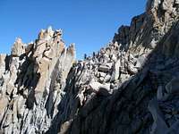
The trail crosses over to the west side of the ridge, where the slopes are less than the sheer eastern face. Magnificent spires or needles adorn the ridge on the first part of the remaining 2.5-mile trek up to the summit. These drop to v-shaped notches that ended literally at our feet along the trail. The other side of each notch was a spectacular drop. I thought these could be dangerous places on a windy day. Luckily, the weather remained fair and calm. The last bit of the climb was rather flat and almost anti-climatic after being on top of those spectacular cliffs. After some effort I reached the summit at 10:45 AM, 6 1/2 hours from the trailhead. There were a fair number of folks on top, but I never felt that it was overcrowded. After a while John and Steve made the summit as well. We celebrated, took photos, and signed the summit register. The register box was on the side of a stone emergency shelter built near the top of the mountain. I wouldn't want to be up there in a thunderstorm! Our weather remained shirtsleeve warm with temps. in the low 60s, bright sunshine, and essentially calm wind. We could peer over the cliff edge directly down to partially frozen Iceberg Lake a few thousand feet below. The Owens Valley seemed a long ways off and was over two miles below us.
![Whitney Summit View]()
![Kearsarge Pass View]()
We lounged on top for as long as we felt prudent and then started the lengthy trip down. A bit down the trail Steve and I viewed a potential class 3 scramble to the top of one of the spires as worthy of our attention. John, correctly thinking we were temporarily insane, opted to continue down towards Trail Camp. We incorrectly and temporarily identified our goal as Mount Muir. It was an easy scramble to the summit, where we realized we should have consulted the topo. map prior to leaving the trail rather than at the summit. Mount Muir was the minor summit to our north and we were on a narrow unnamed top now dubbed "Trail Crest Tower" overlooking the switchbacks with a huge cliff below us. We were still thrilled to be there. Steve found a summit register in a metal band-aid box, which we proudly signed. We scrambled down and regained the trail. By the time we got to the spring the two liters of water I had carried up from it were long gone. I was happy for a lengthy, cool drink.
John waited for us at Trail Camp. We re-connected and headed back down the mountain. The last bit of trail was interesting as we had started in the dark, and were experiencing the scenery for the first time. We were all a bit fatigued but feeling great about our accomplishment. John and I arrived back at the Portal at a bit after 6 PM. The descent, including the side excursion, was a bit under six hours. Steve was just behind us. We celebrated with cold beer, hamburgers, and hot dogs at the Portal Store. We were back down to the hotel before dark, and I was in bed not too long afterwards. It was a memorable day!
Onion Valley - Kearsarge Pass
John had to return to work on Thursday. After breakfast on Wednesday we said our goodbyes and he drove south. Steve and I stopped by the visitor center to inquire about an easy day-hiking venue. Our interpretive ranger enthusiastically recommended the Onion Valley, about 15 miles north of where we were the day prior. We drove north up Rt. 395 to Independence, and then up another amazing paved road to 9200 feet elevation and the Onion Valley trailhead. The valley is aptly named, as huge wild onions were in bloom everywhere. Actually this was probably the best wildflower viewing of our trip. Steve was much better at remembering his college botany than me and we leisurely climbed the switchback trail.
We started out never intending to summit the pass. There were a couple of alpine lakes on a bench about half way up. Amazingly, our legs felt good and we trudged onward. Five miles horizontal and a half-mile vertical later, we were standing on top of 11,800-foot Kearsarge Pass, gazing down into the high alpine country of Kings Canyon National Park. I was so glad we chose to continue to the top. Upon the way we met the most impressive human story of our trip. A young couple were taking their 4-year old son (walking) and 2-year old daughter (in backpack) on their first backpacking trip. They were headed over the pass and down to camp at some alpine lakes on the west side. They exuded confidence and competence slowly making their way up the pass. We enjoyed our time on top, saw a pack train returning from a drop-off somewhere in the interior, and finally sauntered back down to the parking lot about 5 PM.
![Badwater]()
The evening meal was in the Totem Cafe, which had good food and was a memorable venue. Lone Pine had a huge western film industry through the 1950's in the nearby Alabama Hills. Signatures of Gary Cooper, Jack Palance, Maureen O'Hara, and many others were etched into the wooden walls.
Death Valley and Red Rocks
Thursday was largely a driving day. Steve had an afternoon flight from Las Vegas. My flight was a red-eye, departing at 10:30 PM. We really wanted to experience Death Valley National Park. Fortunately we were limited by time to not spend much time outside of the car. It was too hot to do otherwise. We re-traced the steps of the Badwater Ultramarathon through Panamint Springs, Stovepipe Wells, Furnace Creek, and eventually to Badwater. Badwater is the lowest point in the US at -282 Feet. We had been to the lowest and highest points in the lower 48 within two days of each other. Luckily most of the journey was by automobile. I couldn't imagine running for an hour in that heat, let alone for a few days straight (135.2 miles). The temperature in the shade at the Furnace Creek visitor center was 105F before 10 AM. I'm sure it reached 120F later in the day. We walked out on the salt flats at Badwater, pausing for pictures. On the way back to the highway we detoured through Artist's Drive, a one-way loop road which passed some interesting rock formations. We caught up with two tour buses at the Zabriskie Point viewpoint (ugh!) There are a lot of mountains in the park as well, rising as high as 11,000 feet directly above the baking desert plain.
[img:643431:alignleft:small:]
After what seemed like a long drive across the desert we stopped in Pahrump, Nevada for lunch. We continued down NV160 and I had Steve at the terminal by 2:30 PM. After considerable frustration with credit cards trying to gas up, I escaped Las Vegas and headed towards the Red Rock Canyon National Conservation Area. This is just a short drive west of Vegas and was highly recommended. I spent the late afternoon and early evening exploring the rock formations, including enjoying a few short walks as the temperature dropped below 100F.
I made it back to the airport and on to my redeye flight without incident. We logged 60 miles on foot and 1100 in the rental car. A few brief but grateful hours of sleep and I was back in Philadelphia heading home to Lillian and Aspen. All in all a fine adventure!


Comments
Post a Comment