
-
 2769 Hits
-
 75.81% Score
-
 6 Votes
|
|
Route |
|---|---|
|
|
36.16616°N / 115.44263°W |
|
|
Scrambling |
|
|
Spring, Fall, Winter |
|
|
Class 4 |
|
|
Overview
Although this is not the most direct route up Red Cap, it is more challenging both in climbing difficulty and route-finding than what is considered to be the standard route is. The route is both fun and beautiful, with variations that make it slightly shorter and slightly harder, and it is highly recommended.
This route is essentially the same as the one SP member cp0915 describes in his excellent Rambles and Scrambles: The Definitive Guide to Peakbagging Around Las Vegas, currently out of print as it undergoes revision for a second edition (otherwise, there would be a link here), but whereas his begins from the southwest base of the peak, this one begins from the northwest base and then traverses the west face until meeting CP's route higher up and closer to the south side.
Getting There
From Charleston Boulevard (Route 159) west of I-215 and Summerlin, turn onto the Scenic Drive in RRCNCA. Just before Mile 3, you reach the signed Sandstone Quarry area (it is the third developed pullout along the road); turn off and park here.
Route Description
Distance to the summit is about 1.5 mi, with approximately 700' of elevation gain. Expect a fair amount of Class 3 and a few spots of Class 4. If you do not like Class 4, not even very short pitches of it, do not try this route, for two key sections are Class 4 (though on the easier side of it, but that is subjective).
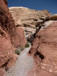
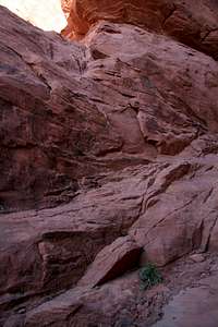
About 3 minutes along the Calico Tanks Trail from its junction with the Turtlehead Peak Trail (or about 5 minutes from the parking area), you will reach a spot where the trail bends sharply to the right as it meets a wide, gravelly wash. Leave the trail and follow this wash-- avoid going left when you intersect another fairly wide wash-- through and over some small dryfalls and narrow sections that would feel like slot canyons if the walls were a bit higher. This wash will take you into open terrain near the left end of the peak’s western face. There are many ways to get there, ranging from easy to hard, but the easiest is probably this wash. A photo below shows the wash where it meets the trail.
 |
 |
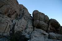
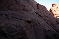
At the northwestern base, hike up easy sandstone slopes and get as high as you can before the slopes turn into cliffs. At that point, start traversing south (right) across the western face, aiming for a section with dryfalls and a gully. This may sound vague, but it is easy to locate on the peak, as going either too high or too low will result in cliffing out. And there is a picture below of this as well.
Climbing along the dryfalls puts one on what is considered the traditional route up Red Cap. Instead, climb up and through the gully (Class 3), which is the key to continuing the traverse across the west face.
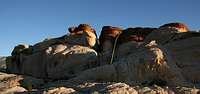
As you reach the end of the west face, you will want to work up and left (east) to get to the south face. There are a number of ways to do that, but the most direct way short of Class 5 terrain seems to be the spot seen below.

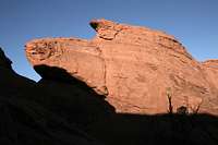
On the south/southeast side, spot some dryfalls and a gully just to the right of them. Climb the gully (Class 3) until you are at the top and next to a red block that seems to be the summit. It isn't, but it's easy to scramble up this block and see the true summit a very short distance away.
 |
 |
 |
Descend a short distance (50-60 vertical feet) in a gully on the other side, and then, where yet another gully joins the one you're in, just before a brushy spot, climb up that gully to reach a notch; this is the notch above the dryfalls on the other side, and you are between the subsidiary summit and the true one. Now descend about 15 feet back onto the south side to a tree and then climb to the right up a short Class 4 wall.
 |
 |
 |
 |
When you reach easier ground, hike left around the summit block until on the northwest side you reach a short (about 8') crack that goes at Class 3+/4. This crack is next to what may be the standout feature of Red Cap, a small tinaja just below the summit. Please stay out of the water in order to protect the fragile organisms that make it their home.
Climb the crack and then walk to the summit, which is less than a minute away.
 |
 |
 |
Variation 1
On the south side, instead of climbing the gully next to the dryfalls, climb one of the dryfalls. Both are Class 5, but both are climbable for skilled scramblers experienced with going unroped on Class 5 terrain. The one on the right is the easier one, mainly because it is fairly easily accessed via a short exposed traverse from a boulder to its right (the bases of both dryfalls are difficult to start from; the one on the left is wide with smooth, overhanging rock, and the one on the left is sheer and smooth); 5.2 seems about right to me, but it is not harder than 5.4.
Above the dryfalls, you are just below the short Class 4 wall mentioned previously that accesses the summit block, so this route removes some of the zigzagging nature of the main route.
Variation 2
If the dryfalls are not to your liking or are in bad condition, follow the main route as described but instead of descending from the notch to the Class 4 wall, climb up and to the right from just below the notch (on the north side, to be clear). This is maybe 25' of Class 4 climbing and lands you directly at one end of the tinaja. Walk around the tinaja to the 8' crack and finish the climb.
 |
 |
The benefit of this route is that it is slightly shorter and, of course, adds variety. It does not change the difficulty much at all; the Class 4 wall here feels slightly easier than the Class 4 wall on the south side.