
-
 21118 Hits
-
 94.23% Score
-
 46 Votes
|
|
Mountain/Rock |
|---|---|
|
|
36.16616°N / 115.44263°W |
|
|
Scrambling |
|
|
Spring, Fall, Winter |
|
|
4925 ft / 1501 m |
|
|

Overview
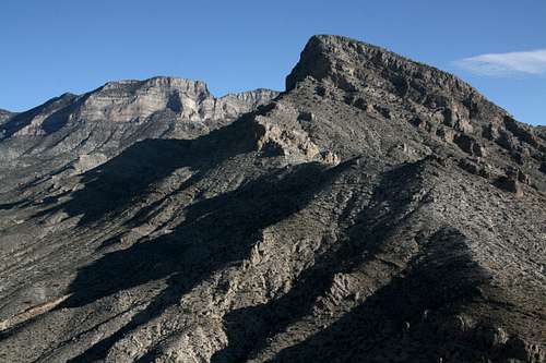
Red Cap, also called Turtlehead Junior, perhaps for its proximity to Turtlehead Peak, is the highest peak in the Calico Hills, a small area of colorful sandstone peaks and outcrops in the eastern section of Nevada’s Red Rock Canyon National Conservation Area. The mountain might be small, and the elevation may be nothing to elicit gasps, but this little peak packs a lot for the punch. First of all, its colors are striking. Second, it offers at least two fun and challenging routes to its summit. Third, it is situated in a position that yields spectacular views of the best of the Red Rocks area. Fourth, there is a (sometimes) water-filled tinaja (“tank”)-- a depression that collects rainwater-- just below the summit block, and it is both a geological marvel and a great feature for framing a nice photograph.
Note: the tinajas are crucial to the survival of desert species both aquatic and terrestrial (examples-- brine shrimp and desert bighorn sheep). Please do not wade, swim, or bathe in; drink from; or otherwise defile this or any other tinaja.
Red Cap is an unofficial name-- my source for it is the guidebook Rambles & Scrambles: The Definitive Guide to Peakbagging Around Las Vegas by SP member cp0915; this book is a wealth of information on peaks within a day's drive of the Las Vegas area and has an extensive collection of route descriptions for peaks in Red Rock Canyon National Conservation Area-- but one look at it will dispel any wondering about the name. Red Cap is a peak composed of yellow sandstone capped by a layer of dark red sandstone. There is no other peak like it in the Calico Hills-- some are all yellow, some are all red, and some are red with yellow caps, but only Red Cap is yellow with a red top-- and that makes it easy to locate.
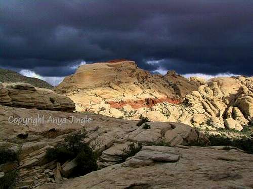 By Anya Jingle
Routes
I know of four routes up the peak, all of which I have done. Each has a good deal of Class 3 scrambling with at least two spots of Class 4. Route pages added cover these routes in detail. There may be other scrambling routes.All the routes are 2-4 miles round-trip with 650-700' of elevation gain for those from the west and 1300' from the east.
"White Gully"
This route was recommended to me by MoapaPk. It has less exposure than the other routes do, the route-finding is less complicated, and the climbing is easier overall, but there are two Class 4 spots (these are the exit from the gully to the summit area and a short crack that leads to the summit block; the gully itself is Class 3).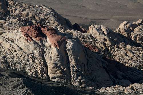
West Face and South Face
This largely matches the route described in the guidebook mentioned above but starts from a different point, at the northwestern base of the peak. It is somewhat complicated to follow but not as much as it sounds. It is the longest of the three west-side routes but probably the most fun, and it has the hardest climbing though it is not much harder than the others.West Face
This is the traditional route up the peak and the shortest one from the west side. The photo below, with its caption and notes, describes it very well. The route page has more photographs and goes into more detail, though.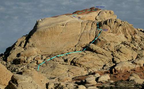 By MoapaPk
From Calico Basin
Longer, but no fees! See the attached route page for details.
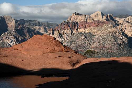
Some Summit Views
These are better when you click on them and then click on "Orig."
Getting There
From Charleston Boulevard (Route 159) west of I-215 and Summerlin, turn onto the Scenic Drive in RRCNCA. Just before Mile 3, you reach the signed Sandstone Quarry area (it is the third developed pullout along the road); turn off and park here.There is also a route from Calico Basin; please see the attached route page for details.
Red Tape
There is a daily entrance fee of $7 per vehicle (2013). Annual and interagency passes are available (the Interagency Pass, AKA the America the Beautiful Pass, grants access to all federal fee areas for a year).
Hours the Scenic Drive is open:13-Mile Scenic Drive
Note: these hours are subject to change. To be safe and sure, contact the park before visiting.
Hours the Scenic Drive is open:13-Mile Scenic Drive
| November through February | 6 a.m. to 5 p.m. |
| March | 6 a.m. to 7 p.m. |
| April through September | 6 a.m. to 8 p.m. |
| October | 6 a.m. to 7 p.m. |
Note: these hours are subject to change. To be safe and sure, contact the park before visiting.
The BLM (the agency that manages this area) allows dogs in the backcountry. Please keep them leashed and pick up their feces.
There is no entrance fee in Calico Basin.
Tracy - Apr 18, 2009 7:06 pm - Voted 10/10
Nice peak pageI enjoyed reading this one Bob, and I look forward to hiking it; however, one thing you might want to check on....According to John Kirk's website, "listsofjohn.com" this link: http://listsofjohn.com/PeakStats/Climbers.php?Id=47614 is the actual highpoint of Calico Hills and is higher than the one the 'MyTopo' link connects to on the Red Cap (Turtlehead Junior) page. I only point that out because you state in the narrative that Red Cap is the highest peak in Calico Hills. Tracy
Bob Sihler - Apr 18, 2009 7:20 pm - Hasn't voted
Re: Nice peak pageThanks, Tracy. Interesting that you mention this other peak; I put up a page for it the other day! New Peak Peak 4987, New Peak, is more limestone than sandstone, and a basin separates it from the concentration of the Calico Hills, and I think that's why my source (who, to make matters more complicated, is the source mentioned on the Lists of John page!) does not include New Peak as part of the Calico Hills but rather as a peak in Calico Basin. So for now, I'm sticking to my guns! Thanks for the heads-up. Bob
Tracy - Apr 18, 2009 11:34 pm - Voted 10/10
Re: Nice peak pageSounds reasonable! I like that other page too. Thanks for bringing it to my attention.