-
 8925 Hits
-
 78.27% Score
-
 9 Votes
|
|
Route |
|---|---|
|
|
38.39747°N / 111.20998°W |
|
|
Scrambling |
|
|
Spring, Fall, Winter |
|
|
Less than two hours |
|
|
Class 3 |
|
|


Overview
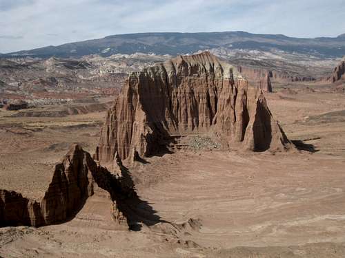
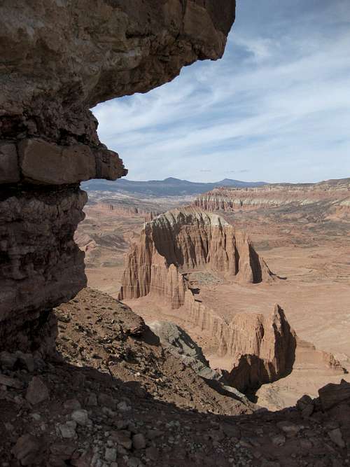
When you reach the end of the spur to Lower South Desert Overlook, you can be forgiven for not noticing the fine scrambling objective just southwest of you. After all, the look you're getting at Jailhouse Rock is probably drawing you to the short trail leading to an unrestricted view of it.
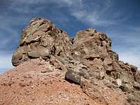
But after you've turned the engine off and before you yank open that door, look to your left a bit and notice a ridge with a small but very prominent pinnacle on it. It never gets too crowded out here, but if you'd like to virtually guarantee yourself some solitude and even better views, put on your Class 3 hat and head out. Trad climbers skilled on truly rotten rock may want to try the pinnacle itself, but scramblers will be happy to reach the ridge highpoint, which is slightly higher and just beyond the thumb-like pinnacle.
Getting There
2.7 miles east of the boundary of Capitol Reef National Park, look for a signed dirt road leaving Utah 24 and heading to the Fremont River. In short order, you come to the crux of the drive, if you will: River Ford. This crossing is for high-clearance vehicles only, and it is a good idea to have four-wheel drive as well. Make sure you check the water depth first; sometimes the water is little more than ankle-deep, but I have found it knee-deep on occasion, and I have no doubt it gets even deeper after storms and during spring runoff.
After crossing the river, drive about 13.8 miles to the signed turnoff for Lower South Desert Overlook (the turnoff is 14.1 miles from UT 24), passing through spectacular bentonite hills along much of the way. Drive a mile, entering Capitol Reef National Park as you go, to the road's end.
Beyond the river crossing, the road is an easy drive, but the road is dirt, sand, and clay and should be avoided in wet conditions or when rain is likely.
Should conditions at River Ford not be suitable for crossing, you can drive east another 7.8 miles to Caineville Road (9.5 miles from the Capitol Reef boundary). However, it will be a very long approach to this route that way; the one-way distance will be about 46 miles.
You can also approach this route from I-70 at Exit 91. Follow the main trunk road almost 27 miles, first east a few miles and then mostly due south, to Cathedral Valley Junction and then head right to climb from Upper Cathedral Valley to the plateau above, where the road leads to River Ford. The total approach for the route this way is about 47 miles.
All these other roads are dirt, sand, and clay as well and should also be avoided in wet or potentially wet conditions. The climb from Upper Cathedral Valley to the plateau is rough and steep in places but not difficult.
Route Information
It is less than a mile to the summit, and the elevation gain is about 400'.
Strike out for the ridge and then follow it past the pinnacle on its left (south) side. Keep going along the narrowing ridge until you reach the dark summit rocks; scrambling up them is a Class 3 affair.
As you approach the ridge, be careful to avoid the biological crust out here; it is alive and is critical to the desert ecology, and it is fragile. If the soil looks lumpy, dark, or crusty, avoid it. Better yet, try to stay on exposed rock and in sandy washes as much as you can.
It is easier to avoid the biological crust if you hike a short distance on the trail to the overlook and then follow one of the washes as it steepens into a gully and meets the ridgeline.

Essential Gear
Nothing special, but carry plenty of water, especially late spring through early fall.
You are in a remote area. Help is far away, and wet weather can turn the roads to gumbo and strand you. I recommend having enough food and water to spend two extra nights out.
Some Views