
-
 3235 Hits
-
 79.78% Score
-
 11 Votes
|
|
Route |
|---|---|
|
|
38.90706°N / 110.6888°W |
|
|
Scrambling |
|
|
Spring, Summer, Fall, Winter |
|
|
Less than two hours |
|
|


Overview
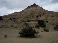
After seeing the Wickiup page go up here, I knew this little peak was something I would enjoy-- an islolated, dramatically colored, and very aesthetic badlands-style summit in a spectacular setting. While badlands peaks tend not to be that big or particularly challenging, they draw me and apparently, at least a few others who find them fascinating.
Because there was already a route page for the East Ridge here and the "mountain" was small enough to explore on all sides, I chose to see what some of the other faces were like. This page covers the southern face of the peak, where there actually are a few ridges but one primary one that leads almost all the way to the summit block.
It is a nice experience on this peak to use one route up and another one down, as all three included here on SP originate from about the same place.
Getting There
The approach is short, but you need a high-clearance vehicle to keep it that way. Otherwise, you will be adding up to two miles each way to your climb.
From Exit 131 on I-70, about half an hour west of Green River, stay north of the interstate as the dirt road there heads east parallel to the interstate. Not a tenth of a mile from the exit, look for a dirt road marked as Trail 642 and turn onto it (a photo attached to this page shows the road and sign). There is another road just before (west of) it, and it does join 642, but it is narrower and a little rougher.
About 0.9 mi of driving leads to a "gate"-- a dilapidated section of wire fence. If it is closed, make sure you close it again after passing through. From here, the road gets progressively rougher as it descends into a wash and crawls over rocky sections. Do not proceed if it is raining or rain seems imminent; even with 4WD, you are likely to get stuck.
Drive for 2 miles past the "gate" until you are in a wash bottom below the south face of the peak. Park (do not block the road) before the road leaves the peak behind as it heads west.
Route Description
One-way Distance: Approximately 0.5 mi
Elevation Gain: About 500'
Difficulty: Mostly Class 2 on loose dirt and rock; some Class 3 on and near the summit block.
There is not a whole lot to say. Climb some low ridges to get a good look at the peak and then start hiking north to the peak.
There is more than one ridge on the south side, but they eventually run together to follow one "best" one to the top. Follow that last ridge to the top and do some easy scrambling to reach the summit.
Footing is loose and unreliable, and you may find yourself using your hands for help even though most of this is not true Class 3 terrain.
Essential Gear
If you are alone, you really don't need anything beyond standard hiking gear. If you are in a group, you may want a helmet since it is very easy to send rocks tumbling down.
