
-
 19692 Hits
-
 94.63% Score
-
 48 Votes
|
|
Mountain/Rock |
|---|---|
|
|
38.90706°N / 110.6888°W |
|
|
Emery |
|
|
Hiking |
|
|
Spring, Summer, Fall, Winter |
|
|
6982 ft / 2128 m |
|
|
Overview
This page was created by former SP member WasatchVoyage. When he decided to leave SP, he transferred this page, the page for the east ridge, and all his photographs for them to me. I have made some minor editing changes but have kept his work mostly intact.The San Rafael Swell area of Utah is rich in interesting geologic formations. The Wickiup, located three miles north of Interstate 70, almost dead center in the middle of the Swell, is certainly no exception. This small mountain grabs the eye from most who pass it by, and it's unique form, shape and colors are quickly left to the imagination. Though not much of a challenge, reaching the top of the summit is rewarding for the views alone. The Wickiup is one of the higher points in the San Rafael Swell at 6,982 feet.
One of the more pressing questions about this mountain is the origin of its name. The term "Wickiup" or Wigwam, was donned by Native Americans, as is described as the following:
"A wigwam or wickiup is a domed single-room dwelling used by certain Native American tribes. The term wickiup is generally used to label these kinds of dwellings in American Southwest and West. Wigwam is usually applied to these structures in the American Northeast. The use of these terms by non-Native Americans is somewhat arbitrary and can refer to many distinct types of Native American structures regardless of location or cultural group. The wigwam is not to be confused with the Native Plains tipi which has a very different construction, structure, and use."
The Wickiup is located just north of The Head of Sinbad, and even has it's own self named USGS quad map. A prominent family, the Swaseys, settled in the Head of Sinbad in 1878. Basing their lifestyle as cattlemen, their domain was expanded from Ferron east to Green River. Many of the place names in the surrounding region were named by the Swasey family. Sid's Draw, a canyon located to the north east of the Wickiup area was named after Sid Swasey. Though there is not much data to support the actual naming of the Wickiup, it was most likely derived from the Swasey family for resembling a wickiup, as mentioned in the paragraph above.
Another local name referring to the Wickiup is "Mary's Nipple." This information was provided from a photo of the Wickiup in the now out-of-print book Utah's Scenic San Rafael," by the late Owen McClenahan. Owen was a resident of nearby Castle Dale, Utah.
 On the approach.
 The shadow cast by early morning light from the summit.
 Sunrise on the Wickiup from the south.
 Looking south from the summit.
 Geology
The composition of the Wickiup is primarily Sinbad Limestone, at the flanks surrounding the base of the peak are slabs of rock with very evident ripple marks that are quite distinct. Also in the center part of the mountain are deposits of Gypsum which glint off light. The Sinbad Limestone, which resides primarily in the Moenkopi Formation, dates back to the Triassic era, between 180 to 225 million years ago.The Swell is a huge anticline, and the rock formations near the Wickiup area are some of the oldest in the San Rafael Swell. The actual core of the Swell area, though not exposed, is located at a depth of 1000 to 1500 meters. The core is the Pre-Cambrian Crystalline Basement Complex, some of the oldest rock on earth. The rock is Archean in age, over 2.2 billion years old. Gneiss and Schist are the usual composition of this rock.
The actual reddish summit of the Wickiup seems to be composed of very brittle, fractured volcanic rock at the very core on the summit. Just below the summit is red colored Moenkopi Shale. Due to the symmetrical shape of the mountain, there is a very real possibility that the mountain's core is a volcanic plug formed during the Pliocene Epoch, about 2-5 million years back. This is speculation and has not yet been substantiated.
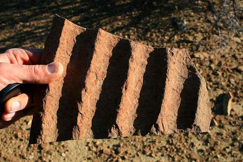 Rippled sandstone found around the flanks of the mountain.
 Utah Geologic Relief Map.
Getting There
This peak is accessed from Interstate 70, either from Fremont Junction, approximately 45 miles to the west, or Green River, 25 miles to the east. From either of these locations, take Ranch Exit 131 and turn north. Just after leaving the interstate, drive north, heading straight into the small viewpoint area, not heading east on the dirt frontage road.Once in the dirt viewpoint area, locate the dirt road leading north. This road is easily passable by any passenger vehicle during summer months and winter dry spells. The road drops down to the hill to the north and begins to turn in a northwest direction. After approximately one mile, you will encounter a barbed-wire fence and gate. For those in a car without clearance or AWD, this would be a good place to park at the road begins to degrade and gets quite rugged ahead. If you park at this location, the Wickiup is on the horizon northwest about two miles. Follow the road to the main TH located at 38.54126 N, 110.41159 W. This is the main starting point for the route leading up to the summit, from the southeast.
If you have an AWD/high-clearance vehicle, you can make it to the starting point of the route as long as the dirt road/trail is not overly wet. There are several parts of the road after the two-mile point from I-70 that may intimidate some; however; it is passable with a higher-clearance vehicle.
USGS quads:
1:100,000: San Rafael Desert
1:24,000: The Wickiup
Please refer to the route page for more information.
 Route from I-70.
Red Tape
This is BLM land. Fortunately, the road leading to the south of the Wickiup has been designated for use by motorized vehicles. However, do not stray off the road, or this privilege could be revoked by the BLM at any time.This area can get very treacherous if there has been recent rain or snow. Though the Swell sees little precipitation, this area does reside above 6,300 feet. Use discretion and check the weather forecast before venturing out.
Camping
There are backcountry campsites everywhere in the Swell. Since it's BLM Land, camping is pretty much open.The closest maintained campground is at the San Rafael Bridge, located about 16 miles to the north. Water/toilet facilities are available, fees included.
More information about the San Rafael Swell.
This area has so much of an abundance of geology, mining exploration, history and folklore that I recommend Michael Kelsey's book Hiking and Exploring Utah's San Rafael Swell. This book covers a lot of the aforementioned topics very well, including an out-of-print public document called A History of the San Rafael Swell by Dee Anne Finken. Also included is a geological overview by Lynn Jackson.
More of Kelsey's books can be seen here.
