
-
 5477 Hits
-
 87.31% Score
-
 24 Votes
|
|
Route |
|---|---|
|
|
41.36100°N / 106.318°W |
|
|
Mountaineering |
|
|
Summer |
|
|
Half a day |
|
|
Moderate to Steep Snow Climb |
|
|

Overview
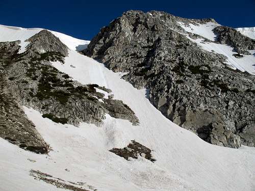
South Klondike Couloir is my own name for this snow climb up to Medicine Bow Peak’s summit ridge. There are two couloirs that run into the Klondike Lakes. North Klondike Couloir holds its snow longer and more consistently than its southern counterpart does. South Klondike Couloir, just to the left, can turn into a mix of snow, dirt, and talus by midsummer and is thus a better climb in late spring and early summer. It is fully visible from the parking area at Lewis Lake. This route has a short approach and easy access and is in a very popular area, but it sees very few climbers relative to all the hikers and fishers who visit.
Getting There
About 8 miles south of Saratoga, WY 130 intersects WY 230, which goes south. Drive WY 130 to the turnoff for the Sugarloaf Recreation Area, which is 29 miles east of the WY 230 intersection. The other end of WY 130 is in Laramie, and those approaching from Laramie will find the Sugarloaf turnoff 12 miles west of Centennial. Drive one mile to the end of the road at Lewis Lake, which sits at about 10,700’. There is a fee of $5 per vehicle. The main road may not open until June, and snow may block the road to Lewis Lake into late July or even August.
If the road to Sugarloaf is closed, you can still hike it to Lewis Lake. You can also hike from Lake Marie, further west on WY 130, or strike out cross-country from a pullout between the Sugarloaf access and Bellamy Lake. The latter route is more direct than the former but is also more strenuous.
Route Description


The full loop from Lewis Lake entails about 3.5 miles and 1300’ of elevation gain. The highest of the Klondike Lakes is at 10,800’, so depending upon snow conditions, the snow climb can be up to 800 vertical feet. When I climbed at the end of June in 2009, the snow was all the way down to the lake.
Start hiking the popular trail to Medicine Bow Peak, keeping an eye on the couloir. Once you are approximately level with the base of the snow, leave the trail and start contouring over to the route. You will be above and west of the Klondike Lakes. Since this is a fragile alpine area, make a serious effort to stay on the rock and not on the tundra as much as possible. The approach should take 15-30 minutes in all.
Although some parts of the climb are moderate, good stretches are steep, especially as you get higher. Expect icy spots as well. There may be a cornice or a too-steep-to-climb headwall at the top, but it is bypassed by moving either left or right (left means a fun finish on snow, and right probably means a less-interesting finish on easy talus).
When you finish, you can hike 20-30 minutes across the ridgetop to the summit of Medicine Bow Peak and then take the trail back to the parking area (you may find yourself on the receiving end of interested and respectful glances, comments, and questions from hikers atop the peak), or you can hike north past North Klondike Couloir and descend a Class 2 scree slope back to the base of the couloir. You could also glissade back down.
Altitude and Weather
The hikes and climbs in the Snowy Range tend to be short, but most of them begin between 10,400 and 10,800'. Take this into account before you start; if you are not acclimated, you will likely be sucking air and have a headache (or worse).
It goes without saying that weather in the mountains is unpredictable, but the weather in the Snowy Range seems especially volatile. I have been there seven times spanning 12 total days, and only on 4 of those days have I not experienced storms or the real threat of them. It is not uncommon for dark storm clouds to fill the sky before 10 A.M. Because you reach treeline so quickly in this range, you are more exposed to lightning, and with fewer retreat options (the only comfort is that short hikes and climbs mean short return trips to the car, though that is little comfort if a thunderstorm hits you when you are on the ridgetops at 11,900').
Essential Gear
Ice axe and crampons.
You may not need the crampons later in the summer or in the afternoon, but I climbed this in early summer and at dawn, and I needed the crampons in places.

