
|
|
Area/Range |
|---|---|
|
|
39.57020°N / 77.5943°W |
|
|
Spring, Summer, Fall, Winter |
|
|
1850 ft / 564 m |
|
|
Overview
South Mountain is not exactly a mountain in the same way K2 or Aconcagua is. However, it is typical of the mountains of the Mid-Atlantic USA and the Blue Ridge in particular. Part of the Blue Ridge Mountains, South Mountain is a long ridge rising a thousand feet above the valleys and farmland of central Maryland. It stretches from the Potomac River at the southern end up to the Pennsylvania border and some distance north--a total distance of about 40 miles in Maryland alone. Along the ridge are various gaps and knobs differing in elevation by as much as 500 feet, spectacular views, surprisingly remote-feeling woods, and quite a bit of wildlife. The actual summit itself is ill-defined and most likely uninteresting in and of itself.What is interesting is the famous Appalachian Trail which runs the length of South Mountain and provides access to the scenic vistas, campsites, shelters, and points of historical note. The AT here is about as gentle and easy as it gets anywhere and veteran hikers can cover great distances. There is a tradition known as the Maryland Challenge or Four State Challenge; starting from Harper's Ferry just over the river in West Virginia, hikers try to cover the entire 40+ mile length of the Maryland Appalachian Trail in one day.
Geography of South Mountain
South Mountain is so long and is in such a populated area that I can't just list two trailheads and be done with it. For convenience, I've split South Mountain into four distinct sections defined by gaps with major roads in them. The Potomac Appalachian Trail Club publishes a series of excellent maps covering much of the MidAtlantic AT. Maps 5 & 6 (one item) covers Maryland and is indispensable.High Rock Section
 High Rock View
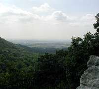 View at Raven Rocks
This is the northernmost and most rugged part of South Mountain and runs from PenMar Park on the Maryland-Pennsylvania border (thus the name) down to Smithsburg (Raven Rock Hollow) for six miles. Along the way, the AT climbs up High Rock where a stunning view to the west awaits. The climb up to High Rock is the steepest section along the Appalachian Trail in Maryland. Farther along, the Devils Racecourse Shelter offers a place to sleep and a chance to explore the fascinating river of rocks which is the Devil's Racecourse. Shortly before crossing the road, Raven Rocks appears as a series of short, wooded cliffs on the trails left.
Black Rock Section
 Black Rock View
 Annapolis Rock
This section stretches along the ridgeline from Raven Rocks Hollow south to I70/US40 in 11 miles. The main attractions on this section of trail are the spectacular Annapolis Rocks and the even more spectacular Black Rocks (which really are not black). Both locations offer spectacular vistas to the west and dozens of quality rock climbing routes. Two shelters (Phillip Cowell at the northern end and Pine Knob at the southern) are located along the trail in this section as well as two campsites (Pogo and Annapolis Rocks). Access is by a trailhead on US40 at the south, or Wolfesville Road (MD17) on the north.
There is also a trail to Black Rocks from White Oak Road on the west side of the mountain. Take exit 35 off I70 and head north on Mapleville Road. Turn right on Mt. Aetna road and right again on Crystal Falls road. White Oak road will be on the left after abot a mile and there is parking for half a dozen cars at its terminus.
Monument Section
 View from Washingtons Monument
 Washington Monument
This is a short, easy section between US40/I70 and Alt US40 covering 5 miles of rolling, wooded terrain where you'd hardly know you were on a mountain. Mountain laurels bloom beautifully here in May.
The main attraction in this section is the Monument Knob. Three monuments were built to George Washington, each one larger than the next. Most people are familiar with the obelisk in Washington, DC (the last of the three) but fewer know about the milk-bottle-shaped tower on South Mountain. It is located in a State Park and hikers can climb to the top for a nice view during open hours.
Trail access for this section is at US40 on the north or the Washington Monument State Park near the southern end. For the latter, take Alt 40 from Frederick on the east or Hagerstown on the west. Just at the crest of the mountain, turn north onto Monument Road and drive 1 mile to the park.
There is also parking available on Alt 40 in the ample parking lot of the South Mountain Inn. There are no official campsites or shelters in this section.
Southern Section

The southern section is the longest in every sense of the word covering 14 miles from Turner Gap (Alt 40) to the Potomac River. For much of this distance, the trail travels straight down the ridgeline on good terrain. The historic Gathland State Park lies in the middle of this section and marks the location of a small Civil War engagement. There are some nice views from White Rocks on the south side of Lambs Knoll. However, the best scenery on the route lies at Weaverton Cliffs on the southern end of the mountain with good views down to the Potomac. From the base of Weaverton Cliffs, it is an easy amble along three miles of the C&O Canal towpath to Harper's Ferry and various amenities.
Two shelters serve this section, the Rocky Run Shelter in the north and the Crampton Gap Shelter near Gathland State Park. In addition, the Dalgren Campsite at Alt 40 provides tenting space, picnic tables and showers! The Weaverton Campsite along the C&O canal is another option for camping.
Red Tape
No access issues. South Mountain makes a good hike at any time of year. There is no camping allowed in either Gathland or Washington Monument State Parks. All camping and camp fires must be at the existing campsites listed below.When To Climb
Any time is fine. The climate of central Maryland is very benign. Spring and fall may be the most pleasant for moderate temperatures. Weekends are usually very crowded.Camping
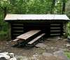
Camping is available at 5 AT shelters along the trail as well as four established campsites. From north to south, these sites are as follows (mileages are from PenMar Park, a few tenths of a mile from the PA border):Mile 5 - Devil's Racecourse Shelter
Mile 9.5 - Ens. Phillip Cowell MemorialShelter
Mile 13.5 - Pogo Campsite
Mile 15.5 - Anapolis Rocks Campsite (half a mile west of the AT)
Mile 17 - Pine Knob Shelter
Mile 23 - Dahlgren Campground (showers!)
Mile 24.5 - Rocky Run Shelter
Mile 29.5 - Crampton Gap Shelter
Mile 37.5 - Weaverton Campsite
 Devils Racecourse
 Phillip Cowell
 Pine Knob Shelter
 Rockey Run Shelter
 Crampton Gap Shelter
Rock Climbing at South Mountain
Maryland is not known as a rock climbing mecca, but there are at least four notable places to climb along South Mountain. In the north, Raven Rocks has a dozen or so short lines and makes for a good day of cragging. Weaverton Cliffs on the southern end is similarly an underutilized destination.Annapolis Rocks is heavily climbed despite the 2.5 mile hike up a fairly steep trail to get there. There are several outcrops at Annapolis Rocks and routes from easy to aid. The famous Nixon's Nose route is featured on the cover of Eric Horst's Mid-Atlantic Climbing. The other classic route in the area is Black Crack (5.9) with some exciting bulges and steep jam-crack climbing. Unfortunately, Annapolis Rocks is often crowded with adventure groups and getting a route on summer weekends is a challenge.
Less well known but of similar quality is Black Rocks. It's another mile from I70 and thus sees much less traffic. Climbers may find approaching via the White Oak trailhead a more attractive option than schlepping 3.5 miles each way up the AT. Blackrocks has at least three major outcrops of hard quartzite sandstone and various classic climbs.
Mountain Conditions
