


Comments
No comments posted yet.
|
|
Trip Report |
|---|---|
|
|
40.30700°N / 111.588°W |
|
|
Jul 14, 2007 |
|
|
Hiking |
|
|
Summer |
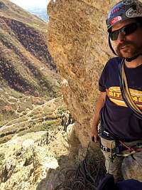
On Saturday July 14, 2007 I joined a group of 7 other people who were doing a hike from Big Springs Park to the Cascade saddle. The plan was to hike with the group to the saddle, enjoy the views from there, have lunch, and then two of us planned to continue on to Cascades South Peak. As the group assembled in the morning, another member decided he would join on our quest for the peak.
Big Springs Park is located south of Vivian Park up Provo Canyon. To get there from I-15, take the 800 North Orem exit and head east. 800 North becomes Provo Canyon Rd as it enters the canyon. Three or four miles up the Canyon turn right into Vivian Park and continue up that road past Vivian park, past Giles Ranch, and to Big Springs Park. Park in the last (west most) parking lot, as the hike to Cascade Saddle starts here from the northwest corner.
The trailhead has an elevation of 5130 ft, the saddle is around 9650 ft, and the South Peak of Cascade is at 10,761 ft. The distance from the parking lot to the saddle is just over 5 miles; and the distance from the saddle to the peak is just under 2 miles.
We began hiking at 8 am. The single track hiking trail initially paralleled a gated dirt road, intersecting it at the Boy Scout camp after about a mile. At the scout camp fresh water was available from a faucet. From the camp the trail continued west to the saddle, occasionally switching back and forth.
Half of our group of 8 arrived at the saddle by 11 am. From the saddle, the top of Cascade still looked a long ways away, and we couldn’t see any defined trail that would lead us up.
We ate our lunches and took in the views of Shingle Mills Mountain, and Provo Peak, to the immediate south, as well as Utah Lake and “happy valley” to the west, as we waited for the other half of the group to arrive. As we ate lunch we convinced the fourth member of our sub-group to continue with us toward the peak. Several times we wondered if the other half of the group had turned back, but just as we finished lunch they arrived and we took a few group pictures before parting ways again.
By noon, we began our push to the South Peak from the saddle. Initially we simply followed the ridge in a northward direction and it took us up and over a grassy hummock, to an even higher and bigger knoll. Across the next knoll we went now heading northwest. After about an hour, and several gains and losses of elevation, we were surprised at far away our goal still was, and we were starting to realize that we may not have enough water to compensate for the rising temperatures of a hot July day. Around this time the last to join our peak bound group, decided he was not prepared for it and so he turned back.
As the three of us continued higher, we were constantly amazed by the views, and the solitude. A few times we heard mountain goats, and on one of our breaks we were astonished by the plethora of dragon flies hovering at such a high altitude. As we continued route finding in a northeast direction we eventually reach a plateau giving way to views over looking Rock Canyon and Squaw Peak below. At this point we turned west for a few yards, and scrambled up to the main ridge that would lead us northward to the south summit. We arrive at the South Peak (10,761 ft) at 2:45 pm. From the saddle to the peak we found that staying on the ridge as much as possible was the easiest and safest route.
The views looking west were amazing and allowed us to look down on Squaw Peak and Rock Canyon. I was of the opinion that the view of Utah Lake was the best I had ever seen. To the northeast we could see Deer Creek reservoir and to the south we easily identify Shingle Mill, Provo Peak, and Nebo mountains. It was a very hot day, and though we had the energy to do the extra 1.25 miles (each way) to the North Peak (highest peak), we had ran out of water, so we decided to save that peak for another day (perhaps an east ridge attempt via Bunnels Fork).
On the South Peak was a foot long piece of 3 inch diameter black plastic pipe with a screwed on cap. The heat of the day had expanded the pipe, and we were not able to remove the lid to get at the log book inside, however someone had left a piece of signed rawhide inside a jar and so we instead signed that to log are summit success.
On the way down, two of us tried to take a short cut down the south side of the knoll mentioned earlier. We did this by cutting down to a visible terrace that we thought would lead to the saddle. In the end, the short cut dropped us four terraces down from the saddle, on it’s west side, which meant a hike up, and without water, in the worst heat of the day, in direct sun. When we finally climbed back up to Cascade saddle, where we were to rejoin the third member of our group, we could neither see nor hear anyone. Realizing that he had ignored the plan and gone ahead, we started down the saddle trail toward Big Springs, which thankfully offered a few shade trees. Fortunately we soon caught up to our lone member at which point I noticed that he was suffering from the first signs of heat exhaustion. We paused in the shade for awhile to ward off the heat exhaustion, but needing water we had to soon continue on. After four and a half hours without water, around 7:30 pm, we arrived at the Boy Scout camp at Big Springs, and to much needed water.
All in all Cascade was a strenuous all day hike, but definitely worth the effort!