
-
 4654 Hits
-
 74.01% Score
-
 4 Votes
|
|
Route |
|---|---|
|
|
51.26530°N / 115.7736°W |
|
|
Mountaineering, Trad Climbing |
|
|
Summer |
|
|
A long day |
|
|
5.4 (YDS) |
|
|
Alpine/Trad |
|
|
I |
|
|
Approach
This is a 5000’+/- ascent day and I recorded 5300’ on my altimeter. The beauty of Mount Ishbel is that you gain the ridge fairly early, limiting the amount of bushwhacking involved. Most of the approach is through a marshy area that was part of a prescribed burn quite a few years back, so it is fairly easy going. Make sure to take a compass reading before leaving the road. You will be able to scope out the appropriate place to gain the ridge from the road. The south ridge is roughly an eight kilometer ride to the summit. |  | 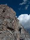 |  | 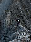 |
Route Description
Head due north along the right side of the large meadow, through several Aspen stands and up to the south ridge of Ishbel. You should gain the ridge in the region of 6500’, still well below tree line. We observed one male Spruce Grouse on this ridge. The sheep provide a respectable trail that ascends the ridge direct to your first rock step. This will be an easy going face with a corner to scramble up. You will traverse left at the top through a keyhole to find easier ground saving some elevation loss. There will be several traverses from east to west and vice versa as you travel north, mostly just moderate obstacles until you come across a steep problem blocking the ridge, keep right to bypass this section and it continues to some enjoyable hands on climbing back to the ridge. You weave back left again to traverse below the ridge on the west side and regain it up some loose ledges. Now, most of the ridge goes on the east side to the summit. The most airy crux you will come across entails a solid downclimbing move or two on the left with extreme exposure, but good rock for holds. My partner chose to take a ramp down the east side and work her way back up to the ridge. This manner of retaking the ridge from the east via some 5th class moves pretty much defines the final 1200’ up Mount Ishbel.Eventually I came to a razor thin section leaning to the east. The most noticeable aspect of Mount Ishbel is that the rock gets considerably worse the further you progress. This leaning flake of the ridge crest was conspicuously hollow and fractured. At this juncture, we had noticed for quite some time that we could in fact have taken a ledge full of scree straight up the east side to the east ridge and ascend to the summit from there. It was at this point that we had enough of re-attacking the ridge and down climbed roughly 30 meters to this ledge. As soon as I reached this ramp there was a cairn, so evidently we were not the first to abandon the weak knife edged ridge. We took easy street to the east ridge for 400’ and then turned west to ascend via decent hands on climbing through a few steps for the final 100 meters or less.
There was a summit log at the summit in 2005. The summit affords great views of Mt. Assiniboine as I caught a good glimpse of her while on the ridge and before storm clouds moved in on us. Of course being in the Bow Valley, the closer views include Copper Mountain, Storm Mountain, Ball Mountain, Castle Mountain, The Finger, Mount Bell, etc.
Throughout our ascent, we were chased by a black cloud or two. Our relaxing summit jaunt was interrupted by the “singing” of my alpine ax attached to my backpack on the ground. As I grabbed the pack in my hand and flew off the summit in retreat both my partner’s and my helmet became “alive” with electrical current, despite hers having no apparent metal parts. I believe this is a phenomenon where as the current is coming through our feet and resting in our helmets. I could feel the current the second time it occurred and we set a record for descending the top 100 meters of this peak. In fact when we came to the first of three rappel stations on descent of the east ridge, we quickly down climbed ledges to the right to avoid having to stop and attach our harnesses and therefore, more metal to our bodies. By the time we reached the second rappel station we felt comfortable we were out of harms way.
The rappel stations puzzle me somewhat on the east ridge, as I felt I could downclimb all three of them, but we did use number two and three and continued to descend the east ridge to a corniced col between Ishbel and an unnamed peak to the east. Carry on down this ridge until it becomes easier to descend via a gully to your left. Watch the rock fall from this point on. A serious alpine accident has been documented on this descent. Once out of the gully, we chose to start descending to a snow patch below the cliff bands versus descending completely to the col. We found that this ground made for an easy descent. Once down to the snow, we enjoyed a moderate glissade to a grassy knoll where we finished our lunch. While I awaited my partner at this spot, I observed a Ptarmigan hen directing her five chicks to disperse in equal distance and hide under rocks as she remained visible and close to distract me. It was quite the show. From the grassy knoll, descend down a large drainage to Ranger Canyon. This section is an avalanche slope free of thick trees and brush until the final 15 minutes before the canyon. Once in the canyon, follow Ranger Creek (good luck keeping your feet dry) southwesterly until you finally bypass the steep slopes and ridge on your right and can enter the forest to follow your opposing compass “start reading” back to the meadow and your vehicle. We discovered a lone Elk carcass through this old prescribed burn area, which now serves as an ecosystem rich in grass.
 |