
-
 4562 Hits
-
 74.92% Score
-
 5 Votes
|
|
Route |
|---|---|
|
|
44.01411°N / 10.33521°E |
|
|
Hiking |
|
|
Spring, Summer, Fall |
|
|
Half a day |
|
|
Overview
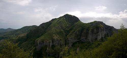
 Monte Corchia, Pania della Croce, Monte Forato Monte Corchia, Pania della Croce, Monte Forato |
There are two routes following the south ridge of Monte Forato, both starting at the saddle Foce di Petrosciana. One is the Ferrata Sentiero Renato Salvatori, the other a hike, circumventing the difficult part of the ferrata. Both have the start in common, a steep scramble on the south ridge, but after a while the normal route turns right, leaving the ridge. Since the intersection is somewhat hidden you might find yourself missing the ferrata altogether.
There are two trailheads for the hike, one at the village of Stazzema, one at Rifugio Matanna. You can combine them by hiking a loop around Monte Nona with the additional climb to the summit of the latter. Also, there is another ferrata onto Monte Procinto, a tower in the west of Monte Nona, which is touched by the itinerary from Stazzema. On a long summer day you might also think of inculding Monte Croce and Monte Matanna into a hikathlon.
Getting There
 Monte Croce
The main page details the itineraries to both the Stazzema and Rifugio Matanna trailheads. Access from Stazzema is slightly shorter, however you have about 1000m of elevation gain compared with about 600m from Rifugio Matanna.
Route Description
- Start altitude Stazzema: 447m
- Start altitude Rif. Matanna: 1007m
- Summit altitude: 1223m
- Prevailing exposure: East and West
- Type: Easy until Foce di Petrosciana, steep scramble across the south ridge, later easy again
- Protection: None
Stazzema trailhead
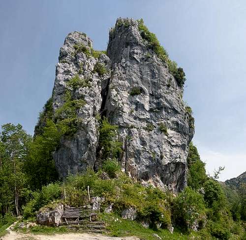 Torri del Prato
Hike the road through the village to its end. There two hiking trails await you, which both lead you to Colle del Prato, a nice lookout saddle underneath the towers which make up the end of the Monte Nona - Monte Procinto Ridge. The trail splits in two with the right branch leading towards Rifugio Matanna (to be considered if you think of a look tour), the left one leading to Foce di Petrosciana. The latter trail rises slowly towards the saddle, constantly leading through a dense beech forest which only occasionally reveals a view towards Monte Forato and Pania della Croce.
Rifugio Matanna trailhead
 |  |
From the rifugio turn north on trail 109 through the forest which covers the east slopes of Monte Nona. After a short while the path descends steeply towards Foce delle Porchette, the saddle between Monte Nona and Monte Croce. Here a steep gully awaits you through which a mostly comfortable hiking trail leads you underneath the north face of the latter mountain. A short traverse leads to Foce di Petrosciana.
Normal Route
 In Passo dell Arco
In the saddle a sign points to Sentiero Renato Salvatori, the south ridge ferrata to Monte Forato. The path climbs steeply across the south ridge, which is very brittle and poses dangers of rockfall. There is one short protected section even before the ferrata begins. You can miss out on the ferrata completely (believe me) since its starting point is marked by a very small hidden sign only.
If you do, a broad hiking trail awaits you, one of the main trekking routes which lead from Foce di Petrosciana to Foce di Valle and eventually to Pania della Croce. It runs along the east slopes of Monte Forato, always staying close to the south ridge of the mountain. Again a dense beech forest obstructs all views until you have passed the main summit of Monte Forato. A sharp col offers a nice view towards Monte Corchia. In this saddle the ferrata rejoins the normal route, both passing a big gendarme before reaching Passo dell'Arco, the saddle with the giant arch. From here a steep scramble takes you to the panoramic north summit of Monte Forato, at 1209m.