
-
 24081 Hits
-
 83.69% Score
-
 17 Votes
|
|
Mountain/Rock |
|---|---|
|
|
44.01411°N / 10.33521°E |
|
|
Hiking, Scrambling, Via Ferrata |
|
|
Spring, Summer, Fall |
|
|
4012 ft / 1223 m |
|
|
Overview
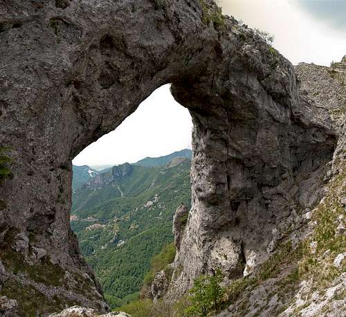 The Arch between Monte Forato's summits The Arch between Monte Forato's summits |
Among the mountains of the southern Alpi Apuane Monte Forato takes a special place. At 1223m it is only about 100m lower than Monte Matanna, the subgroup's highpoint but it stands out in a quite different way. Between its two summits there is a huge arch (26m high, 32m wide), a wonderful documentation of the karst-like features of the range. Moreover, along the exposed south ridge of the mountain, there runs a difficult ferrata, Sentiero Renato Salvatori.
 |  |  |
The Alpi Apuane are a limestone range, solid in the north but brittle and broken in the south. In the immediate vicinity of Monte Forato this is most obvious with Grotta del Vento, a huge stalactite cave in the south face of Pania Secca, or Monte Procinto, a square limestone tower to the west of Monte Nona. Erosion, mainly by water, has taken its toll on the rock, of which the arch of Monte Forato is one of the best examples. It spans the saddle, which is formed by the two summits of the mountain and is solid enough to be hiked across. Bit make no mistake: exposure is tremendous as the west face drops for 500m into the valley of Cardoso. They say that in some of the villages in the Serchio Valley in October / November and February / March the sun sets through the Monte Forato Arch.
 |  |  |
There are three routes to Monte Forato, two of which head for the summit from the south. The direct ridge route has been developed as a Via Ferrata, the Sentiero Renato Salvatori, a very exposed protected route. It climbs to the main summit across the very brittle ridge before heading down to the arch. Alternatively a hiking route circumvents the main summit by passing it on the eastern side. This route always remains close to the ridge and can be used as an escape route during thunderstorms. A third route climbs the north ridge from Foce di Valli, an easy hike.
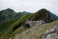
The smaller north summit offers wonderful views towards Pania della Croce, Uomo Morto and Pania Secca
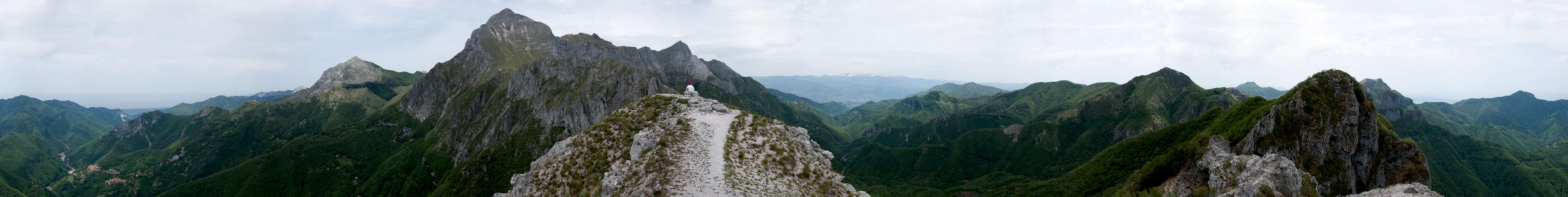
360° Summit Panorama
  |
Getting There
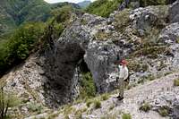
 Monte Forato's summits as seen from Pania Secca
There are two possible trailheads, one at Stazzema directly to the west of Monte Forato, the other at Rifugio Matanna further away to the south. From Pisa or Firenze (Florence) the itineraries are as follows:
 |  |  |
- Stazzema Trailhead:
- Take motorway A11 to the coast
- Switch to motorway A12 north
- At the exit Pietrasanta take SP9 through Seravezza to Stazzema
- Rifugio Matanna Trailhead
- Take motorway A11 to Lucca
- Switch to SS12 in direction Abetone
- At Borgo a Mozzano switch to SP2
- After 10km turn left onto SP37 through Fabbriche di Vallico and follow the signs to Matanna
Red Tape
 Smiling Lizard
The Parco Naturale delle Alpi Apuane was established in 1985 to protect the nature as well as culture of the area within which the Alpi Apuane are located. Its overall size amounts to almos 21000 ha. A constant challenge is the presence of roughly 300 marble quarries which their impact on the environment. A hiker might easily find himself inside one of the quarries and is requested to follow signs and rules there (especially for the start of the western route).
The park's official website
Accommodation
Accommodation is relatively easy to find along the coast of the Tyrrhenean Sea. Viareggio, Massa, Carrara and La Spezia offer lots of hotel rooms as well as campgrounds. Either book them by travel office or go for a google search.On the other hand, to stay closer or within the range you can make use of Agriturismo, farms, which offer food and lodging. The site of the Natural Park has a selection of all kinds of accommodation of the area:
Weather Conditions
Maps & Books
Maps
- Alpi Apuane - Garfagnana
Kompass Verlag
1:50000
ISBN: 3-85491-852-6
- Geological Map Parco delle Alpi Apuane
1:50000
L. Carmignani, P. Conti, L. Disperati, P.L. Fantozzi, G. Giglia and M. Meccheri
Maps Online
Books
- Tuscany North / Toskana Nord
Wolfgang Heitzmann / Renate Gabriel (translation: Gill Round)
Rother Verlag
ISBN: 978-3-7633-4812-1 (English)
ISBN: 978-3-7633-4115-3 (German)
- Guida al Parco delle Alpi Apuane
Edited by: Giuliano Valdes
Series: Guide Felici
ISBN: 88-88327-91-6
- Guida all’Alta Via del Parco delle Alpi Apuane
Angelo Nerli
Felici Editore Srl
ISBN: 88-6019-006-1