Approach
From the parking lot at Ski Valley, hike or drive two miles up the paved road to the summit of Mount Lemmon. This section of road is closed in the winter. Find the Mount Lemmon trailhead and follow it 1.2 miles southwest to the intersection with the Sutherland Trail. Follow the faint Sutherland Trail 0.8 miles west, along the south side of the east-west ridge. Work your way over to the north-south ridge leading to Samaniego Peak. Leave this trail for the faint, Samaniego Ridge Trail.
Route Description
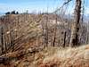
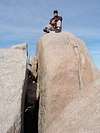
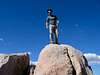
Follow the ridge almost straight north to the summit, now three miles away. You will cross several ravines. Keep heading north toward the peak, which is visible in front of you from time to time. The last hundred feet or so is a refreshing scramble over huge boulders and burned tree skeletons to an exposed summit block. Stand on the summit block if you dare, and post your photo here.
Round trip elevation gain is about 3800 feet, not counting the paved road. The destination is lower than your starting point by quite a bit, but there is plenty of up and down, both directions.
Essential Gear
Detailed topo map. GPS helpful. Long pants (for protection from nasty thorn bushes).
Miscellaneous Info
If you have information about this route that doesn't pertain to any of the other sections, please add it here.