
|
|
Mountain/Rock |
|---|---|
|
|
32.46950°N / 110.8176°W |
|
|
Pima |
|
|
Hiking, Scrambling |
|
|
Spring, Summer, Fall, Winter |
|
|
7690 ft / 2344 m |
|
|
Overview
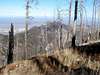
Samaniego Peak (pronounced SAH-men-YAY-go) lies on the western fringe of the Santa Catalina mountains northeast of Tucson, Arizona. Although it is a close neighbor to the popular Mount Lemmon, and only 5.5 miles by foot from a paved road, Samaniego Peak is seldom climbed. In fact, only one party signed the Samaniego summit register in all of 2004. Views from the summit are spectacular in any direction.A major forest fire ravaged all sides of Samaniego Peak in 2003, as you can see in several of the photos. The plant life is returning, however, and large deer still call Samaniego home.
 |  |  |  |
Getting There
 Views Getting There
You may access Samaniego Peak from several starting points. In addition to the two listed below, it is also possible to reach Samaniego via the north ridge but I do not know the starting point. Maybe some reader can attach that info here.
Catalina State Park At 2700' elevation, the trailhead provides access to Sutherland Trail from the west. Take highway 77 north out of Tucson past Oro Valley. There are numerous other trails accessible from within the park. To climb Samaniego Peak from here is 26 miles round trip, approx. 5600' elevation gain.
Ski Valley: At 8300' elevation, provides access to Samaniego Peak from the east and south, via Mount Lemmon and the Arizona Trail system. Take Catalina Highway northeast out of Tucson into the Santa Catalina mountains. The trip up the Catalina Highway can be compared to a trip from Mexico to Canada, with vegetation ranging from the giant Saguaro cactus in the lowland deserts to pine, fir, and spruce at the highest elevations. To reach Samaniego Peak from here is 15 miles round trip, and approx. 4600' elevation gain.
Red Tape
Pay a $5 fee at the fee station located on the highway going up into the Santa Catalinas. The $5 daily pass is valid at Mt. Lemmon, Madera Canyon, and Sabino Canyon, as if you could see them all in a day.Mountain Conditions / When To Climb
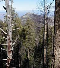 A glimpse of Samaniego
Samaniego Peak is in the the Coronado National Forest, Santa Catalina Ranger District. Visit their web site for current information on mountain conditions. You may contact the local Forest Service office at the number below. They were helpful when I called.
Santa Catalina Ranger District
5700 Sabino Canyon Road
Tucson, AZ 85750
520-749-8700
Samaniego Peak may be climbed year around, although spring or fall would be the ideal time. In years past, the upper portion of the road to the top of Mount Lemmon closed when snow accumulated. Beginning in December 2008, and in following years, roads and day use sites affected by winter weather will be closed annually on the same date, December 15, and reopen on March 1. The roads remain open to hikers, cross country skiers, bicyclists and other non-motorized users.
Hikers should be prepared for high winds, and sudden changes in weather. Check the National Weather Service Point Forecast for Samaniego Peak before you go, and err on the side of safety.
The University of Arizona points a web cam toward the Santa Catalinas.