
|
|
Route |
|---|---|
|
|
47.55280°N / 121.4922°W |
|
|
Technical Rock Climb |
|
|
A long day |
|
|
Class 4/5 |
|
|
Author's Fiat
This is merely a general description. I'm not going to dumb down the enigma too much. And before you think this is still a long description, know that I am leaving out quite a few details.From Garfield's Feet to His Knees
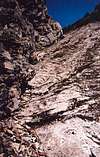
From the gravel wash, walk up the rocky streambed. It soon steepens. Cut right into woods and pick up a bootpath paralleling the stream, which shortly becomes a slabby chute. The bootpath climbs and climbs and climbs with a huff and a puff to eventually reach a small basin (not really a basin, per se) at ~2,300 ft. A narrow rocky gully will be visible off to the left. Descend 40 feet to the creek (last water is here in late season) then climb up the gully. The gully goes on and on but is mostly easy. If you can't handle free climbing the few short Class 4 steps in it you might as well turn around now.At the apex of the gully (approximatley 500 feet above the basin), exit left into forest then arc around rightward to a low-angle slab (the approach slab). Climb this slab directly (Class 3 or 4 depending on route taken) most of the way to its top. Look rightward for a cairn atop a log/stump. The bootpath continues from there and climbs to the "rock outcrop." Good views from there, including Garfield's throat waiting to swallow you down.
 |  |  |
From His Knees to His Throat
Walk up the outcrop then take a bootpath again. There are multiple routes through here. The leftward tack will lead to a gully with rock step impasse above that will force you back right into steep woods. This will lead to the "razorback", a fun scramble along an arête. Drop off the razorback (bootpath) to a gully (now above the step impasse). Fork rightward a little ways up the gully (don't stay in the gully) and climb steep fern/brush to a forested saddle (the "glade").Continue across a forested ledge with mucho exposure to the right. There are two inclines here followed by ledges. My memory is a little fuzzy here, but essentially you want to contour across the slope until you arrive at an overlook into the "No. 1 Gully". You will know it when you see it. It ascends directly to a notch on the WEST side of Leaning Spire. To get to the gully requires a short 100-ft traverse across a sloping, dirt ledge (fatal fall here in April 1965). This is known as the Key Ledge Traverse. It isn't hard but is exposed. A variation by way of No. 1 Gully is possible (the party ahead of us went that way) but we took the other variation.
From the base of No. 1 Gully descend 10 feet then round a small buttress (Class 4) for 30 feet to steep trees. Pick up a faint bootpath. Climb to a ramp then more woods until you arrive at No. 2 Gully.
 |  |  |  |  |
Up his Throat to the Top of His Head
Climb up the No. 2 Gully keeping to its left side. It eventually becomes a deep fault slanting southeastward--the left wall overhanging and the right slabs slanting into the corner under the overhang. Kind of interesting, really. There are many variations through here. Pro will be sparse on the slab and even in the corner. We stayed close to the corner as long as we could. Climb several steps of varying difficulty ranging from Class 3 to Class 5.8. The crux (for us) was a short climb of 15 feet between slab and overhang that required a pack-free ascent. The lichen and moss on the rocks often complicates matters.Above the crux there is a flat area where the No. 1 Gully alternate route comes in from the left (by way of a short wooded ledge). The gully continues up and becomes more difficult to stay in. The bypass is up the rib on the right. This rib alternates between open rock and vegetation (firs, pines, heather). Some of the climbing is low 5th Class rock (unprotectable) but most is just steep woods (Class 3/4) with lots of trees to sling if need be.
When the rib makes a pronounced step up (a small tower), go left through annoyingly dense trees to reach a heathery gully/slope (Class 2). Climb this slope to its top. Now either go left again around a corner and finish the climb via another heather slope (Class 3 but very steep) or go right up a minor depression (Class 4) to a final grass terrace about 40 feet below the ridge crest. Climb Class 4/5 rock to the crest then turn left for the final 50-100 feet to the summit (Class 3+ scrambling along the crest including one short, fun knife-edge shimmy 'n shake).
 |  |  |  |  |
More photos
 |  |  |  |  |
Descent
Take the steep heather slope for the descent. Cut left when feasible back to the Class 2 heather slope. Descend this to an evergreen tunnel leading through to the slopes above the Leaning Spire-Main Peak notch. Scramble down to the notch. It is easiest to go right (north) across the slabs on a ledge to easier terrain slightly northeast of the notch. The descent is largely Class 3 but exposed at the bottom.You can find rappel stations in multiple locations. Some of these stations are merely old slings so take your chances. We did 3 double-50m rappels down the upper part of No. 2 Gully to the flat area (above the crux part) then 2 more in the lower part of No. 2 Gully. We then reversed the route, rappeling the approach slab from the tree at upper left (a narrow ledge leads over to this tree from the bootpath).
Time = 10-16 hours round-trip, longer if you are beset with delays; Gain = 4,300 ft + sundry ups and downs.
 |  |  |  |
Essential Gear
All your own water in late season.Two 50 meter ropes if you can manage it. We did five double-50 raps and one single-50 rap. This greatly expedited the descent.
A small alpine rack. We had four cams and seven nuts. Most of the time in the all-rock areas there is no protection available (the rock is not highly fractured). You could take a piton or two but I don't know how useful these would be.
Plenty of runners, preferably of the longer variety. There are lots of trees to sling.
LONG PANTS.