South West Ridge of Prominent Point

South West Ridge of Prominent Point

Page Type Page Type: Route
Location Lat/Lon: 32.36614°N / 110.89669°W
Additional Information Route Type: Scrambling
Seasons Season: Fall, Winter
Additional Information Time Required: Most of a day
Additional Information Rock Difficulty: Class 4
Additional Information Grade: II
Sign the Climber's Log

Overview

This is possibly the most scenic route on Prominent Point. Starting at the edge of a major metropolitan area, it quicky leaves road and trail behind, works its way up steep slopes of cactus and shindaggers, weaves past cliffs and outcroppings, then follows an elegant ridge with exquisite views both south across Tucson, and north into the wild chaos of rocks, spires, cliffs and other attractions that define the land to the south of Catalina State Park.

The route is fairly straightforward all the way to the West Summit. However, the summit of Prominent Point is cut by a deep gash, and the highest point, now so close you can almost touch it, is still an intricate maze of scrambling, bushwacking and route finding away.

Getting There

The Moon above the Eastern Edge of Pima Canyon
 The Thumb  on Prominent Point
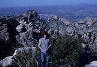
On the route to Prominent Point.
There are two possible places to start this hike, either the end of Campbell Avenue or at the Pima Canyon trailhead. As noted in the Peak page, the very end of Campbell Avenue goes into a gated community where most are not welcome, but there is a parking area just before the gate, then a narrow strip of land between two barbed wire fences that must be followed for half a mile before reaching the National Forest land.

The second approach, with a much more scenic start than the Campbell Avenue option, is to begin your hike along the Pima Canyon Trail. To reach the trailhead, follow Ina Road off of I-10 as it leaves Tucson to the North. Continue East for several miles past Oracle Road eventually reaching Christie where you will see a sign for Pima Canyon. Turn left (North on Christie and follow this to Magee Road where you will turn right (East)and follow it to the parking area for Pima Canyon.

Route Description

Prominent Point from the West The upper part of the South West Ridge.
From the parking area at Campbell Avenue, (3,000 feet elevation) walk along the strip between two barbed wire fences north, towards the mountains for maybe two-thirds of a mile until you reach National Forest Service land. From here, turn right (east) and traverse beneath the south slopes of Rosewood Point until you are able to turn north in a major drainage that comes down from the slopes of Prominent Point. Be sure not to go too far south on this traverse, as this would put you at the once popular Campbell Cliffs, which is on private land and is off limits to climbing. Continue around east of Rosewood Point, turning to the northwest up a side valley that leads to the saddle separating it from Prominent Point. The hike along this section is in largely open terrain with the usual challenges of prickly pear cactus, agave and the like.

This same saddle can be reached from Pima Canyon. From the trailhead, walk along the trail east underneath the south slopes of Pusch Peak for about a mile until the trail turns north and makes its way into Pima Canyon. Once to the north of the steep rocks of Rosewood Point, bushwack your way southeast up mostly open terrain to the saddle. The side canyon you will follow is opposite the canyon leading up to "The Cleaver" on the west side of the valley.

 The Thumb  on Prominent Point The Thumb
Once at this saddle, contour north and up, around steep cliffs guarding the upper reaches of Prominent Point. It may be necessary to scramble a bit, but in fairly short order you will reach easier slopes above. From here the route becomes quite obvious, passing to the left (northwest) of the "Thumb", and continuing near the ridge crest for a mile to the Western Summit. Along the way, an ascent of the Thumb can be made by a crack in the northern side of the formation. The scramble is steep, and although we used a rope, it isn't really necessary since the chimney is so secure.

A second possible line can be followed if you start at the Campbell trailhead. Low down, just after traversing past Campbell Cliffs and working your way to the east of Rosewood Point, continue straight instead of turning left to the Rosewood Point-Prominent Point Saddle. It is possible to follow this watershed in a direct line up to the Western Summit of the Peak. There is a place where it may be necessary to scramble up rocks to the left of the actual stream bottom to avoid cliffs. After working back into the bottom of the wash, continue up very steep rocks to the crest of the ridge south of the summit.

Some hikers may stop at the Western Summit of the Peak. It is a wonderful vantage with expansive views. However, the true summit is still a couple hundred feet away. If you want the adventure of finding the route yourself, don't read on as it's an entertaining puzzle to get up those last couple feet.

Summit Detail of Prominent Point
Summit of Prominent PointView from the Eastern Summit.
To continue, descend to the northeast working down through thick bushes until you are able to reach the notch between the peaks. From here, there is a straightforward crack that leads directly up the West wall of the Eastern Summit to the peak, however, it appeared to be 5th class climbing to me. For a technically easier line, drop southeast from the notch descending along the southern edge of cliffs descending from the true summit. This is steep but fairly easy until just before this gash reaches another that angles up to the east of the main summit. Here, there is a short steep wall. The descent and climbing of this wall had a couple 5th class moves in it, but they were only a couple feet above the ground, so its all really just a little bouldering problem. Once in this eastern gash, use it to climb back up and north past many trees to to ridgeline again, this time east of the Eastern Summit. A final scramble along the ridge gets you to the true summit.

To descend, repeat the ascent route.

Essential Gear

Prominent Point
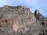
Prominent Point from the south. Photo by Juh33.
Climbing the Thumb
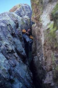
An ascent of the Thumb
You don't really need anything special for this hike beyond sturdy shoes, water, and whatever else you normally bring on a dayhike. The peak can be climbed without technical climbing gear for people proficient with rock scrambling.

If you wanted to attempt the crack on the west wall of the East Summit, you'd want to bring a few large cams and I'm almost thinking that you'd want them to be really big, but it's been a long time and my memory's foggy.

Parents 

Parents

Parents refers to a larger category under which an object falls. For example, theAconcagua mountain page has the 'Aconcagua Group' and the 'Seven Summits' asparents and is a parent itself to many routes, photos, and Trip Reports.