
|
|
Mountain/Rock |
|---|---|
|
|
32.36614°N / 110.89669°W |
|
|
Scrambling |
|
|
Fall, Winter |
|
|
6628 ft / 2020 m |
|
|
Overview

There are several peaks clustered around the highest reaches of Prominent Point. Of the two main summits, the East one is a couple feet higher, and is separated from the West by a deep gash. Traversing from one of these peaks to the other is a long and involved process unless you use technical climbing (or are very bold). To the East of this is the famous Finger Rock, a dramatic spire hanging elegantly above the city. Further East still is a pretty peak with sharp cliffs on its Southern and Western aspects which gives a beautiful symmetry of sorts to the peak. A long ridge extends to the South-West from the Western summit to beyond the vicinity of "The Thumb". This gives the peak a deceptively gentle appearance from some angles, masking the abundant layers of cliffs that guard almost every aspect of the peak.
Despite its proximity to a major city, an ascent to the summit of Prominent Point is surprisingly wild and challenging. In the summer, there are abundant rattlesnakes and debilitating heat, while snow and ice are possible in the winter, particularly on the northern aspects of the peak. There are no trails to the summit, which makes the summit and the views that much more rewarding, but also means that on south facing slopes you will have to traverse many patches of "shindaggers" (stepping directly on them works best), while the upper elevation north facing slopes contain thick brush. Third to fourth class scrambling is required to reach the topmost summit of the peak.
Getting There
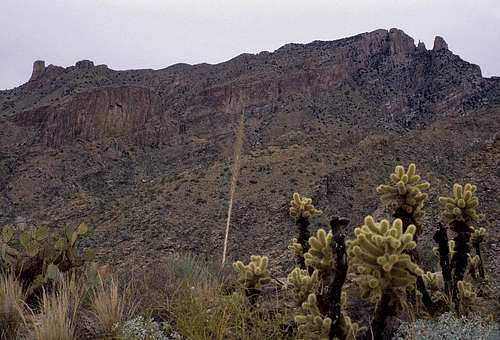
Prominent Point is located only a couple miles from Tucson. Perhaps the quickest ascent of the peak can be made from the north end of Alvernon Avenue, a mile north of its intersection with Skyline Road. For this approach, you will take the Finger Rock Trail about a mile across gentle terrain, then once you reach the wash along the bottom of Finger Rock Canyon, follow it up towards Finger Rock, or climb two more miles and follow a steep use trail to evenually reach the same place. View along the Pima Canyon Trail.
A third possible approach, with a much more scenic start than the Campbell Avenue option, is to begin your hike along the Pima Canyon Trail. To reach the trailhead, follow Ina Road off of I-10 as it leaves Tucson to the North. Continue East for several miles past Oracle Road eventually reaching Christie where you will see a sign for Pima Canyon. Turn left (North on Christie and follow this to Magee Road where you will turn right (East)and follow it to the parking area for Pima Canyon. From the parking area, you will walk along the Southern Edge of the mountains (Pusch Peak)for about a mile before turning North into Pima Canyon directly to the West of Prominent Point.
Routes to the Summit
 Cliffs to the Southwest of Pima Canyon.
A more involved and brushier means would be to ascend the long slope to the West of the Western Summit to the vicinity of Point 6300, just to the Northwest of the Western Summit, then turn South and reach the Western Summit up a steep and brushy face. I haven't climbed this last slope, but we did follow the route to Points 6260 and 6300 with their spectacular views and minor stretches of 5th class climbing at their apexes. The route to this point was straightforward and the final sloped face looked brushy but not technically difficult.
When To Climb
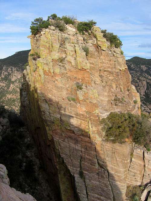 The East Summit from the Western one. Photo by Juh33
Red Tape
Prominent Point within the Coronado National Forest, and forms a part of the Pusch Ridge Wilderness Area of the Santa Catalina Mountains. Being a wilderness area, there are no motorized vehicles allowed.If you are planning on camping, call the Pima County Parks and Recreation at 520-877-6000 for an overnight parking permit. Set camps away from trails and flowing watercourses. The National Forest Service recommends using existing campsite locations when possible, or sandy ground if not.
Since Prominent Point is in the Desert Bighorn Sheep Wilderness Area, camping and hiking off of maintained Forest Service trails is not permitted from January 1 - April 20 of each year.
In the Mid 1990's, the parking area just before the gated community on Campbell Avenue began sporting signs saying that a permit was needed to park in the lot. I will attempt to determine whether that is still the case in the next few days, and tell where to obtain the permits if needed, since this trailhead allows for a wonderful ascent of the peak.
 Prominent Point from the Pontatoc Ridge.
Camping
There are some excellent camping spots in Pima Canyon. The only caution I can think of is that our car was broken into once when we camped in Pima Canyon, so as always, don't leave valuables within the car.External Links
An excellent guide is:Trail Guide to the Santa Catalina Mountains, by Eber Glendening and Pete Cowgill, Rainbow Expeditions, Tucson, 1987.