

-
 40004 Hits
-
 78.25% Score
-
 9 Votes
|
|
Route |
|---|---|
|
|
47.56496°N / 121.1798°W |
|
|
Download GPX » View Route on Map |
|
|
Hiking, Mountaineering, Scrambling |
|
|
Spring, Summer, Fall |
|
|
Half a day |
|
|
Class 3 |
|
|
Mostly a Walk Up |
|
|
Overview
This is the easiest and most commonly climbed route for Mount Daniel. For the most part this route is a simple walk up, although it has a few class 3 moves on it. The route travels about 14.5 miles round trip, has roughly 5,000 feet of elevation gain, and can be done in a single day.Getting There
 Cathedral Rock from the Trailhead
From Seattle: Head East on I-90 for about 78 miles until you get to exit 80 toward Salmon La Sac/Roslyn. Once off I-90 take a left (North) onto Bullfrog Rd for about 3 miles. This merges into highway 903 which you go left onto the highway for about 1.2 miles. From here turn left onto W Pennsylvania Ave and then take the 3rd right onto W 4th St (Horvatt Rd). The same road your driving on changes names a few times, it changes back to highway 903 and then Salmon La Sac Rd. But don't worry, it's all the same road you been driving on. The road eventually takes a minor turn and turns into Nat for Dev Rd 4330. Take this road all the way to the end which is where the trail head starts on the left side of the road.
Route Description
The Southeast Ridge of Mount Daniel starts right at Peggy's Pond. It is not the ridge you see slightly north of the pond - that's the east ridge. The southeast ridge does not even look like a ridge when viewed from Peggy's Pond - it is the "hill" lying DIRECTLY west (thanks to esseattle for correction) of the Pond. Multiple "social" or climbers' trails start at or near Peggy's Pond and converge together atop of the ridge a few hundred feet above the pond. Generally, the north (right when viewed from the Pond) side of the ridge provides a more gentle start. Once atop the ridge, the climbers' trail is well defined - if it vanishes temporarily in a boulder field, just look for numerious cairns. Follow the ridge eastward passing Circle Lake far below on your left and the permanent snowfield on your right below. The ridge gradually narrows as you climb. Few class 3 sections are interspersed with mostly class 2 trail hiking. The highpoint you see ahead of you and to the right is the East Summit of Mt. Daniel.Follow the ridge as it turns north toward the East Summit. At this point, the climb steepens. You want to stay to the left of the ridge crest in a dirty gully. After moving past a few minor gendarmes (class 3 sections), you'll reach a nondistinct low point at the foot of the East Summit (there's a medium sized cairn). From here you should move left off the ridge and begin traversing the scree below (southwest of) the East Summit maintaining constant elevation. The trail is very faint when you first leave the ridge but becomes very clear once directly below the East Summit.
Follow the climbers' trail to the saddle beneath East Summit and a ridge protruding from the Middle Summit. Climb left up scree (approx. 200 feet) to reach the top of this ridge (opposite to East Peak). Once at the top, Middle Summit is directly to your north and the West Summit is the highpoint to your left (northwest). Head for the Middle Summit and turn left below it following the ridge top (above Lynch Glacier) toward the West Summit. The true summit is atop the tallest of the rock spires (class 3).
Essential Gear
Due to this being a moderate scramble, you do not have to bring much.Mandatory Gear for the Climb:
- 2-3 Liters of Water Per Person
- First Aid Kit
- Hiking Boots (climbing boots not needed)
- Plenty of Food
- Sun/Glacier Glasses
Depending on the season and what you are comfortable with, consider bringing:
- Ice Axe
- Crampons
- Helmet
- Shell Jacket
- Nylon Shell Pants
- Sun Screen
- Map and Compass
- Helmet
- Long and Short Sleeve Shirt
If staying overnight, bring the following:
- Tent/Bivy
- Sleeping Bag
- Ground Pad
- Water Filter/Tablets
- Stove, Fuel, Pot, and utensils (for cooking)
Optional Gear:
- Camera
- Tooth Brush and Paste
- Shorts
- Toilet Paper/Blue Bag
- Trekking Poles
- GPS
Topographic Maps
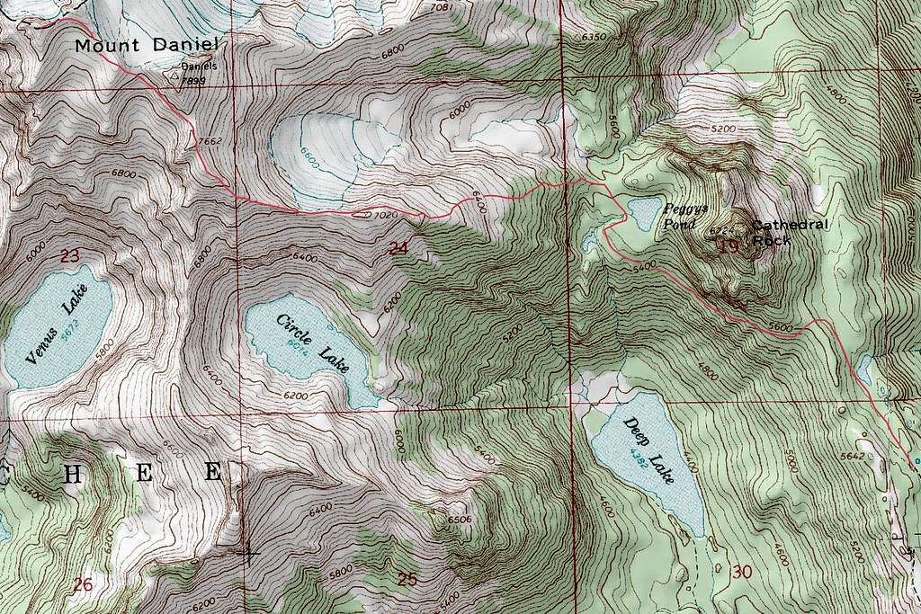
Mount Daniel Topographic Route Map
External Links
- November 29-30, 2008: Shows some great photos, wintery conditions and a map.
- August 22-23, 2011: A two day trip that started out misty but ended up having good weather.
- September 5, 2011: Short, but has some random facts about the route.
- July 7, 2011: A speedy ascent by Raising3Hikers with some decent photos and a quick story on the trip.
- September 25, 2009: Shows a long video of the trip with some processed photos.