
-
 13201 Hits
-
 73.06% Score
-
 3 Votes
|
|
Route |
|---|---|
|
|
39.18720°N / 106.4747°W |
|
|
Hike |
|
|
A long day |
|
|
Class 2 |
|
|
Approach
Follow the same approach given to get to the main Mount Massive Trailhead. There is some nice camping near the trailhead.
Route Description
First of all, a decent topo map with the whole Southeast Ridge on it really helps a lot, otherwise it's more difficult to see the big picture.
This is the route described in the Roach book. The key to this route is finding the correct ridge and following it to treeline. Hike on the main trail for about a mile and start looking to your left for a bend in the trail which goes around the large and steep southeast ridge. Our group did this before sunrise and were able to find the ridge without much trouble - it is fairly obvious. We passed a few spots where we stopped and looked but decided to keep going. When we finally got to the correct ridge there was a rock cairn and a decent path through the woods.
After you leave the main trail things get pretty interesting. There is a faint climber's trail through the woods, but sometimes it would lead into thicker brush or into some fallen trees. I would advise to just basically head straight uphill until treeline. This worked for us in very low visibility and we very rarely had to retrace our steps. This part of the climb was pretty steep but navigating through the woods was really no big deal. I would advise wearing gaiters here, because many of the trees and downed limbs will tear your legs (and shoelaces) apart. Once you break treeline (around 11,700) the routefinding is cake and the route really gets fun.
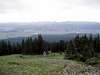
From treeline you have a couple of options. You can follow the ridge proper and ascend all the way up to Point 12,381 which has great views to the west of Mount Elbert, or you can sort of skirt around the northern side of this peak to avoid extra climbing. The point is to end up back on the main ridge eventually. Since this is all above treeline, either way will put you in the saddle and back on route. The views in this area are excellent.
Once you are back on the ridge you must climb the dreaded Point 13,630. To me, this was the hardest part of the entire route. From the saddle to this summit you must climb 1,400 vertical feet straight up the ridge. All I can say is to take it slow because hurrying through here will probably wear you out unless you are used to this kind of exertion at this altitude. We weren't always on the ridge proper, but we stayed near it because going to far from the ridge might force you into more difficult terrain.
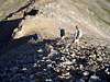
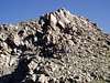
After Point 13,630 you descend northwest to a saddle, and then you ascend South Massive which altitude is listed as 14,132. Going from Point 13,630 to the saddle was obvious and easy, but climbing up to South Massive took a little more thought. There are some serious cliffs on the west side of the mountain in this area, and we heard some pretty major rockfall in one of the gullies. However, if you take your time regotiating the terrain, you can do this section without exceeding any Class 2 terrain. We chose to scramble a bit which was fun, but it wasn't needed.
From South Massive you can see the final climb up to the summit. Descend northwest to yet another saddle (this route is like a rollercoaster in very slow motion) and you will be able to see where the main trail joins back up. Follow the main trail through loose rock to the summit. Make sure you go all the way - the summit is a little farther than we originally thought - there is a register at the true summit. From the top I would descend the way you came back to the saddle of South Massive and the summit and follow the main trail down. We descended straight off the east side to join back up with the trail which proved to be way too much work. Going down the east slope directly was horrible strain on the knees and ankles and also took us through a few streams and pools of water. It might take a little longer, but it would be less effort to backtrack. Once back on the main trail, follow it downhill to the Colorado Trail junction. Go right here, and you will end up back in the parking lot.
One option would be to backtrack the whole route, but I was pretty beat with the descent of the main trail.
This is the information my GPS came up with. Note that this includes our groups version of this route, which may change a little depending on the minor details of the route you take. The info in the Gerry Roach book is almost identical to ours, and other groups had similar data to this:
Miles: 12.6 miles round-trip (descent of main trail)
Elevation Gain: 5,161 vertical feet
This route is great because apparantly few people know about it or try it. We didn't see a single person on this whole part of the mountain, which is a huge area. Once we got to the main trail there were many people hiking. If you like a tougher route with more solitude, give this a shot.
 |  |  |  |
Essential Gear
Nothing fancy needed here - I wore a pair of trail shoes that worked fine. Gaiters help in the woods. I would follow the same rules for all the other routes in the winter depending on the conditions, but I have never climbed this mountain in the winter. A map / compass is (of course) a good idea here especially with the fact that you may be the only person on the whole route. An altimeter is good but depressing because I always assume I have climbed farther, only to look at the altimeter to realize how much farther I have to go.
Miscellaneous Info
If you have information about this route that doesn't pertain to any of the other sections, please add it here.
WalksWithBlackflies - Oct 5, 2005 7:42 am - Hasn't voted
Route CommentI did this hike last year. Simply wonderful. Instead of climbing the rocks on the way up South Massive, I veered to the northeast and got caught on a very loose scree slope. Ascending this slope (two steps up one step down) thoroughly drained me at that altitude. My advice... stay on the rock.
RMdaytripsgrl - Aug 14, 2006 9:13 pm - Hasn't voted
Route finding tipDid this route on 8-12-06. There is no cairn and/or trail for the left hand turn off of the main trail after mile 1 as mentioned in both the Roach book and this description. Looked for it very closely both times through. What we did was hike in about 1.3 miles (per the gps) to a nice meadow with flowers and a stream going through it which was on the north side of the SE ridge and entered here. The forest is very nice here, and you can see what it is you are climbing for. You will notice that the forest prior to this and east of the ridge is messy with a ton of downed trees and brush. Just walk on by this...save a little energy. Also, when you get to those cliffs on the south of South Massive, just go straight up them...the views back over to the west side from the top are priceless. Plus, we wasted WAY too much time in ankle-deep loose stuff trying to stay on class 2. (other person was uncomfortable on loose crud) Just put away the poles and go class 3.
TomSellick - Oct 2, 2006 4:08 am - Hasn't voted
GraciasThanks for the tip - I guess someone knocked that cairn over. Listen to the most recent person up the route, folks!
jomagam - Jul 9, 2007 2:36 pm - Hasn't voted
CommentDid this route on 7/6/7. No cairn, but none needed. We left the trail a couple of minutes after the switchbacks. You'll find Point 12381 as long as you go generally west and keep going uphill. Otherwise it's an awesome hike. There's nothing like being on Point 12381 and seeing how you'll have to do almost 1500 feet elevation in less than a mile. Also watch for the deep gaps between the rocks on South Massive. You could even fall in there they're so deep.