
|
|
Route |
|---|---|
|
|
39.18720°N / 106.4747°W |
|
|
Basic snow climb |
|
|
One to two days |
|
|
Walk-up |
|
|
Overview
This is a very direct route and is perhaps the best winter route to the summit of Massive (or at least the shortest) when the Halfmoon Road is closed. Since we did this route in mid-January and under deep snows, this route description will be geared for winter trips, and I can't comment how it is in summer. There proabably isn't any advantage for using it as a summer route, so you might want to stick to the standard route in summer.You must be able to read the topo map to climb this route.
 Peak 13,680 from timberline along the Willow Creek Route. Clouds always obscured the views of the highest Massive summits. January 16, 2005.
Note: I have been informed (2015) that access to the route has changed. Obey all no trespassing signs.
Getting There
From Leadville drive south on Highway 24 for 3.6 miles. Turn right (west) on State Road 300, then turn left on County Road 11 after .7 miles. Follow County Road 11 for 1.8 miles and turn right on the Halfmoon Road. Follow this road for about 1.3 miles. The Willow Creek Road branches right here, but may be tough to see in winter. The winter road closure varies from year to year or even month to month, but usually it is around this junction. Timberline view, looking west to South Massive from the Willow Creek Route-January 16, 2005. Clouds usually obscured the summit completely.
Route Description
Update, 2015:Access is no longer allowed across the private land on the old route (marked in yellow).
 Click for full size.
Rather than follow the road east from the trailhead, follow the unplowed Forest Service Road South to the forest boundary. From there head westerly cross country until you reach the the road along Willow Creek. I haven't done this section since the old route has been closed.
At the junction of South Willow Creek and Willow Creek, there are several possibilities. Perhaps the best route is to turn due west here. What you are aiming for is the spur that has a point with the elevation of "10,685" marked on the topo. Head for the spur, while navigating through the thick timber the best you can. This will require routefinding, reading the topo map, and preferably, having a GPS. There is a minor hill and then some willows to cross before reaching the base of the spur.
Once on the spur, stay as close as you can to the crest and follow it west. The steepest part is just before point 10,685. If you can manage to stay close to the crest and do a good job of navigating, you should hit the Main Range Trail right where the Mount Massive Trail takes off and heads east. We missed it by only a few yards. From the junction, you just follow the standard route (Mount Massive Trail) west to the summit.
The round trip distance from the trailhead to the summit and back is about 13 miles with 4800 feet elevation gain.
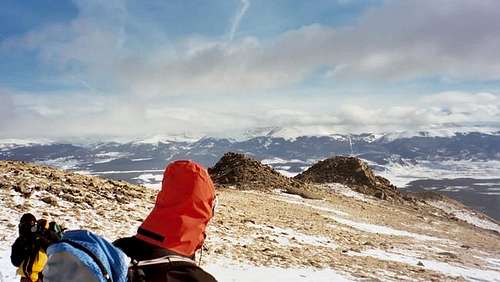 Emilio descending Mount Massive. "Knob 12,466" is the dark colored knob on the right. In summer, the trail actually goes to the left of the knobs, but in winter, we found it more direct to pass them on the right.
Winter Notes
There is usually little or no avalanche danger on this route to Massive, provided you don't stray from the normal route on the upper slopes of the mountain. The route could be done in a very long day, or you can camp near timberline and finish the climb on day two. Unlike Elbert, Massive sees few ascents in winter, so it is likely you will be breaking trail for most of the way to timberline. This is much slower than hiking on a packed trail.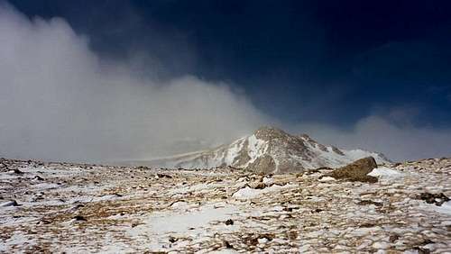 This is about the only view we got of the main summit of Massive due to cloud cover and a storm. This photo is from about 13,800 feet on January 16, 2005.
Essential Gear
Ice axe and crampons might be useful under some conditions, but none of our group used them. Snowshoes and ski poles are a must, as are very warm clothes. Of all the standard routes to one of the Colorado 14'ers, this route (Mount Massive Trail) seems to stay above timberline for the greatest distance, so dress warm. Full winter camping gear is needed for over-night trips. Scott Patterson (left) and Henrik Ronnow (right) on the upper slopes above treeline.