
-
 6091 Hits
-
 94.82% Score
-
 49 Votes
|
|
Route |
|---|---|
|
|
42.33400°N / 112.3275°W |
|
|
Hiking, Scrambling |
|
|
Spring, Summer, Fall, Winter |
|
|
Most of a day |
|
|
Class 2 |
|
|
Overview
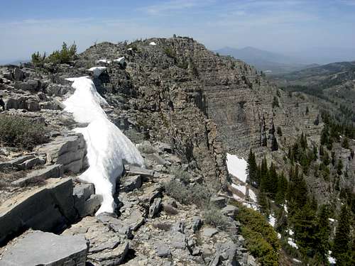
 Summit Ridge
This route goes through Kents Canyon and then climbs up the Southeast Ridge of Elkhorn Peak. When I was researching Elkhorn Peak, I found out that there wasn't any detailed route information available. All I had was a few sentences from the Idaho: A Climbing Guide Book. The route that I ended up taking looked like the most natural line I could see up the mountain. I liked this route but think that the North Ridge is probably easier. So I recommend this route for people looking for more of a challenge. The best thing to do is a traverse of the entire summit ridge by going up the Southeast Ridge and descending the North Ridge and making a nice loop hike. It can also be done in the opposite direction.
Getting There
Drive on Interstate 15 north of Malad City. Take Devil Creek Reservoir (exit 22). Drive north past the reservoir which will be to the right. Continue down this paved road for 3.2 miles until you get to the overpass above I-15. Turn left at the sign for Summit Campground. This turns into a dirt road. It is a little bumpy and wash boarded but a passenger car should be able to make it if you drive slowly. Drive for 1.5 miles and the road will bend north for 0.5 mile. It then goes back toward the west again. You will pass a side road that leads to the Wright Creek National Recreation Trail on the right. Keep driving and stay on the main road which becomes narrow. You will pass the entrance of the Summit Campground on the left. It is a popular place on weekends. Stay on the main road and keep driving until you get to the end of the road. There will be a small turnaround point here where you can park. You should be able to see a creek on the left and a bridge with a trail sign nearby. This is where the trail for Elkhorn Peak starts.
 Elkhorn Peak summit ridge
Route Description
 Elkhorn Peak
 Southeast Ridge
That trailhead is located here (42° 20' 36"N, 112° 17' 23"W). Cross the bridge over the creek. There will be a sign that says South Canyon left and Indian Mill Canyon and Kents Canyon right. Go right and follow the jeep trail for 0.5 mile. This part of the hike is easy with little elevation gain. Expect a few small creek crossings early in the season. You will come to another junction. Elkhorn Peak should come into view to the southwest. Go left towards Kents Canyon.
 Summit Cairn
 Southeast Ridge
Follow this trail for approximately one mile. Sometimes the trail follows the creek bed. There are many places where you can start climbing out of the canyon toward the southeast ridge of the mountain. The location for my choice of route is here (42° 19' 58"N, 112° 18' 35"W). The mountainside is steep for a couple hundred feet to the ridge ahead. Once on the ridge, start hiking west. There will be trees and some rock outcroppings along the way that you will have to go up or around.
As you climb higher the ridge will become a face. This is the steepest part of the climb. It will be just to the left of the huge cliff on the east face. There is a small cliff band about 200 feet below the summit ridge that you must get over. It is not as hard as it looks but the rock is loose. Once above this, it is only a short distance to the top of the ridge. You will get your first view of the other side of the valley. Hike toward the north. The summit can be seen off in the distance and is an easy walk along the ridge.
The first thing you will notice is the giant eight foot summit cairn. Henry Gannett and Allen D. Wilson may have originally built the cairn in 1878 during the first ascent. During my visit, there was a small register in a jar that was on the side of the cairn. The view includes the southern peaks in the Bannock Range: Oxford Peak, Weston, and Old Baldy, the northern peaks in the Bannock Range: Old Tom Mountain and Scout Peak, Malad Valley, Marsh Valley, Deep Creek Mountains, Portneuf Range, Bear River Range, and Northern Wasatch Mountains.
Descent: I hiked back down the Southeast Ridge and was unaware of any other routes at the time. While descending, I noticed a trail that had switchbacks going up to the pass to the north. I assume this is the trail up Indian Mill Canyon. A great way to climb the mountain is to make a loop hike up the Southeast Ridge and down the North Ridge. This would include a traverse of the summit ridge and views of both canyons.
Distance is 6.5 miles round trip with 3,015 feet of elevation gain.
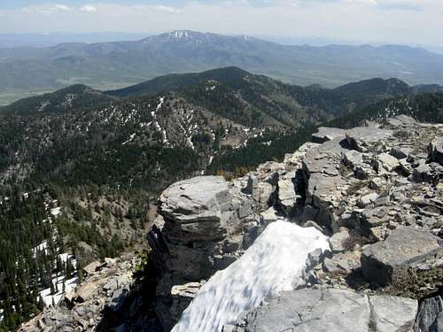 Elkhorn Peak view toward Oxford Peak
Essential Gear
During summer, bring regular day hiking equipment. Hiking boots will be just fine. Bring food, water, and map. A GPS is optional.
In winter, you will need an ice ax early in the season from December through March. Snowshoes or skis will also be needed.
When to Climb
The best time to climb Elkhorn Peak is from May through October. I climbed the mountain in early May during a dry snow year. Indian Mill Canyon was dry and the Southeast Ridge still had snow on the shaded side. Kents Canyon was still covered in snow. I imagine conditions to be much different during a normal snow year. There would probably be more snow in the higher elevations.
In winter, the Southeast Ridge is prone to avalanches with large cornices on the summit ridge. I would climb the North Ridge instead. The dirt road to the trailhead is a good condition but the last mile would be muddy if it is wet. It should be open to the trailhead by last spring. If snow is covering the road, a few miles of walking may have to be added to the hike.