
-
 38470 Hits
-
 75.09% Score
-
 7 Votes
|
|
Route |
|---|---|
|
|
43.18440°N / 109.653°W |
|
|
Hike - Snow/Glacier Climb |
|
|
A few days |
|
|
Class 4 |
|
|
Approach
The Ink Wells Trail is the shortest approach of all the trailheads, and its usage is governed buy the Wind River Indian Reservation. An Indian Guide and permit is required to transport all parties to the trailhead. By using the Ink Wells Trailhead the approach to the Dinwoody Creek is reduced by about 14 miles. Anyone wishing to use this trail should contact The Wind River Tribal Game and Fish Department at 1-307-332-7207. Shuttle fees in 2011 are $125 per person plus the Reservation Trespass fee of $25/day for the day in and out and a $5 conservation stamp. Total, $305 per person in and out. Up to 6 people can travel in one group. Ramona O'Neil runs the shuttle (307) 486-2318. The Wind River Indian Reservation Ranger Station will have information as fees change (307) 455-2466. | 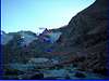 |
Route Description
17.7 miles one way7,200 of elevation gain
M.P.’s are in reference to the trailhead @ 0.0
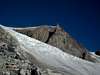
The trailhead (elevation 9565) is located at the end of a dusty road near some springs and feeding areas for cattle. Follow the trail southwest for 0.8 miles (elevation 9730) to a trail intersection. Look for the carin’s to your right or northwest. Follow the trail northwest and west to Scenic pass (M.P. 3.7, elevation 11,450) just passed Dinwoody Peak. There is a very large carin marking this spot. From here start down hill west and then southwest to a trail intersection (M.P. 4.8, elevation 10,890) taking the trail to the right will take you to the Ink wells Lakes which will meet back up with this trail. Stay left and continue southwest until you intersect with the aforementioned trail to Ink Wells Lakes (M.P. 6.5, elevation 10,440). Continue Southwest to Echo Lakes (M.P. 7.5, elevation 10,380); great spot to fish. Continue southwest, while nearing the Big Meadows area a few switchbacks come into play. Descend down to Big Meadows and cross the well built wooden bridge (M.P. 8.9, elevation 9,600.) After crossing the bridge you will intersect with Glacier Trail, which you will follow to the high Tarns. From Big Meadows to High Tarns consists of a nice gentle undulating hike for the first 4 miles with a few stream crossings and than a relatively steep hike to High Tarns. After gaining the Glacier trail head southwest while crossing a stream at M.P. 10.5. This stream is crossed easily on a few logs to the west or up stream. Regain the trail and continue southwest to Wilson Meadows (M.P. 11.7, elevation 9,824). Continue southwest while crossing two more streams and the largest and last one being Gannett Creek (M.P. 13.5, elevation 10,015). All streams had some kind of wooden log crossing, but a little shaky. Due to large run offs the trail can become a little hard to follow for the next few hundred yards. After regaining the common trail follow this through a few switchbacks while heading southwest to High Tarns (M.P. 15.2, elevation 10,800). From Here to the summit is about another 2.5 miles with approximately 3,000 of elevation. Pick you way through the moraine (see photo with image id’s). From here to the peak can be done various ways depending on the level of snow still present and the only MAJOR obstacle would be the bergshrund on Gooseneck Glacier.
 |  |  |  |  |
Alpinist - Jul 10, 2006 3:22 pm - Voted 7/10
Reservation fees in 2006July 2006 - I just booked passage through the Wind River Reservation to the Ink Wells trailhead. The same price was quoted for either 2 or 3 people. The current cost is $600 round trip for the transportation (total), plus $45 round trip per person for tribal permit fees. That comes out to $245 pp r/t for 3 people, or $345 pp r/t for 2 people. Ramona still handles transportation through the reservation. Her number is 307-486-2318. She lives next door to the Crowheart store. Pick-up is normally from the Crowheart store at 8am. Return pick-up from the Ink Wells trailhead is 11am-12pm. You can leave your car at Ramona's house. A tribal permit is required to cross the reservation. Permits are available from the Crowheart store. The store opens at 7:30am on Saturdays.
bchiker - Jun 26, 2011 1:17 pm - Hasn't voted
Shuttle & Reservation Fees 2011Shuttle fees in 2011 are $125 per person plus the Reservation Trespass fee of $25/day for the day in and out and a $5 conservation stamp. Total, $305 per person in and out. Up to 6 people can travel in one group. Ramona O'Neil runs the shuttle (307) 486-2318. The Wind River Indian Reservation Ranger Station will have information as fees change (307) 455-2466.
markandtina@hotmail.com - Sep 14, 2022 10:11 pm - Hasn't voted
Update on the shuttle service 9/10/22We just finished climbing Gannett Peak via the Ink Wells Trail. I wanted to update the information. Sadly, Ramona passed away last December. Her daughter Emme runs the shuttle service now. She can still be reached by calling 307-349-3859. She will set up a shuttle time and date for you. It sounds like she is running a truck up to the trail head about every day of the summer from the beginning of July to September, to take hikers to the trailhead and to pick them up and bring them back down. Also, fees have changed. It is now $350 a person for a round trip shuttle to and from the trailhead. Also, you will need to purchase a fishing license for 2 days to allow you to go on the reservation. The fee for a 2 day fishing license for an out of stater is $100. So the total price to hike 15 miles to the upper camp instead of 24 miles is $450. Also, just a side note. Climbing Gannett in September is great, there were no bugs and there was only one real creek crossing. However, make sure that you bring rock climbing gear as well as your crampons and snow gear. The bergschrund was completely impassable and we had to climb the rocks on the side of the glacier, which involves some pretty steep patches. There are some fixed rappel stations on the rocks.