
|
|
Route |
|---|---|
|
|
37.86030°N / 107.9842°W |
|
|
snow climb, scramble |
|
|
One to two days |
|
|
3rd Class |
|
|
Approach
The trail head is accessed by taking the South Fork Road, which runs along the South Fork of the San Miguel river to Camp Illium, a well marked tourist camp situated on the banks of the San Miguel. South Fork Road can be accessed by taking 145 West of Telluride for about five or so miles. Turn left off of 145 and follow South Fork Road for about three miles. Or, if you are driving in from the south (from Cortez or Dolores), South Fork Road can be accessed before you reach Telluride by turning west (left) at Ames (about 5 miles south of the Telluride turnoff) where South Fork Road enters the highway (on the other side of the highway is the turn off for Ophir).
Turn right at Camp Illium (or Left if you are coming from Ames), and cross the San Miguel river on a small bridge. Follow this road to Sunshine Mesa, where the road ends and the trail begins. As an interesting note, there is an Aspen tree growing inside the trunk of a standing, live pine tree that can be seen on the left side of the road as you get near Wilson Mesa.
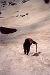
At the trailhead, follow the only trail as it heads southwest and hugs the east (left) side of a valley through which Bilk Creek flows. Eventually the trail crosses Bilk Creek, and continues heading up on the right side of the creek (as you are looking uphill). The trail continues up the south side of the eastern flanks of Wilson Peak and crosses several avalanche paths. In years of heavy snow fall, you will likely see the remnants of the previous winter's avalances, including downed pine trees.
As the trail enters a large, broad basin, head up toward Bilk Basin--the smaller basin between Wilson and Gladstone peak (the basin to the right as you are looking uphill). Continue heading up into Bilk Basin, which involves snow climbing in early season (awesome 1/4 mile glissade on the way down). Once you access the upper part of Bilk Basin, you will find an old miner's cabin situated on a flat step in the steep slopes of the basin (approx. 12, 800'), which is only a few hundred feet below the saddle between Gladstone Peak and Wilson Peak. This area is a good camping spot, relatively sheltered from the wind by the steep walls of the basin. In 1993, the cabin was full of about 3 feet of snow, which wasn't bad for sleeping on in order to get out of the wind.
 |  |
Route Description
Above the cabin, climb directly up and slightly to the right (North) to access the Southwest Ridge. When there is good snow cover, this is a fun snow climb of about 30-35 degrees. An ice axe is recommended, as the snow can be pretty firm, especially in the morning. Just below the ridge, after about 500 feet of elevation gain from the cabin, you should encounter talus slopes and soon intersect a faint trail heading right (North), which is the Southwest Ridge route proper. Follow the Southwest Ridge route description to the summit.
When there is a lot of snow, descent from the miner's cabin can be accomplished by a long, fast glissade down into lower Bilk Basin.
Essential Gear
Because there is so much scree and talus on the route, II wouldn't recommend it unless there is sufficient snow cover. Therefore, an ice axe, and possibly crampons, should be considered. Although the crux of the climb to the summit is a bit exposed, it is not too difficult. Therefore, I do not recommend lugging a rope and pro on this climb.
Miscellaneous Info
If you have information about this route that doesn't pertain to any of the other sections, please add it here.