
-
 9962 Hits
-
 74.01% Score
-
 4 Votes
|
|
Route |
|---|---|
|
|
37.86030°N / 107.9842°W |
|
|
Mountaineering |
|
|
Spring, Summer |
|
|
A long day |
|
|
Class 4 |
|
|
Overview
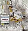 Route Map
Getting There
Follow the normal road approach to the Silver Pick Road Parking area. Leave the Silver Pick Road just before the second gate. Look for the cairn marking trail and turn west (left). Route finding is important since the trail is not well defined. Follow the cairned trail till you reach the open scree slope. A better defined trail was evident in May of 2006 leading across the base of the slope. This will improve over time. Navigate to the point north of the land closure and until it joins the Burro Trail. (See Route Map)
Route Description

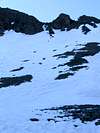
At the top of the bowl climb directly toward the well defined gully that leads to the summit ridge. The gully is full of loose rock and involves some moderately exposed 4th Class climbing. Near the top of the gully angle left on what appears to be an obvious line and finish on the last few meters on the easy ridgeline leading the summit.
Essential Gear
For late spring and early summer conditions crampons and an ice axe are necessary. A helmet is a must!Winter and early spring be prepared for avalanche conditions; beacons, probes and shovels.