

-
 8212 Hits
-
 82.48% Score
-
 15 Votes
|
|
Route |
|---|---|
|
|
48.68056°N / 113.87458°W |
|
|
Mountaineering |
|
|
Summer, Fall |
|
|
A long day |
|
|
One Class 4 cliff (GNP Rating) |
|
|
Class 3 |
|
|
Route Overview
 Vantana navigating the Class 4 pitch
This route found in Volume 3 of Climb Glacier National Park. This is an updated book featuring full color photographs of routes and much more. Find it when you arrive in the area from local retailers or order it from the author on line at Volume Three.
In his description in A Climber's Guide to Glacier National Park, pages 74 & 75, J. Gordon Edwards includes summiting Stanton on the Southwest Ridge Route for Mount Vaught.
Edwards describes this climb as “This is a very beautiful and appealing climb with summit views of the Livingston Range, the Lewis Range and much of the region south of Logan Pass (pg 74).” He is exactly right the views are tremendous! For summit views please visit the Mount Vaught page.
On this route a class 4 pitch must be negotiated while descending from Stanton to the saddle between Stanton and Vaught. Edwards recommends using a rope to belay climbers through this class 4 problem. For those climbers who are used to climbing in Glacier National Park a belay will probably not be needed, but exercise caution anytime when climbing on the rotten rocks in the park.
An alternate route is available for those who prefer to avoid the Class 4 route. This option is also detailed on this page.
Special Considerations:The rock in Glacier Park is widely varied and it is not unusual to find several different types of rock on any given route. Know your rocks and be certain of your safety. J. Gordon Edwards has an excellent section in his guidebook on rock and climbing safety. Be safe and know your limitations as well as those who are climbing with you. Also refer to the following links for further details: GNP Rock and Grading System and the GMS Climbing Guidelines.
 Lake McDonald from Mount Vaught
Southwest Ridge Route Statistics
 Vaught Route
Trail Distance:
2.3 miles from the trailhead to the junction of the Howe Ridge Trail and 3.9 to 4.2 miles of off trail route climbing on class 2 or 3/4 scrambling depending upon route.
Elevation Gains En-route to Vaught’s Summit (does not include descent):
Total Elevation Gained: 6,400 feet or 1,951 meters
Total Elevation Lost: 750 feet or 228 meters
Beginning elevation at Trout Lake Trail Head: 3,200 feet (975 meters)
Trailhead to Climber’s Trail: 5,120 feet (1,920 feet or 585 meters gained)
Climber’s Trail to Stanton Summit: 7,750 feet (2,630 feet or 802 meters gained)
To Low point on Vaught Saddle above McDonald Creek: 7,000 feet (750 feet or 228 meters lost)
Vaught Summit: 8,850 feet (1,850 feet or 564 meters gained)
Choosing not to climb Stanton reduces gain by 150 feet and loss by 150 feet.Southwest Ridge Route Description
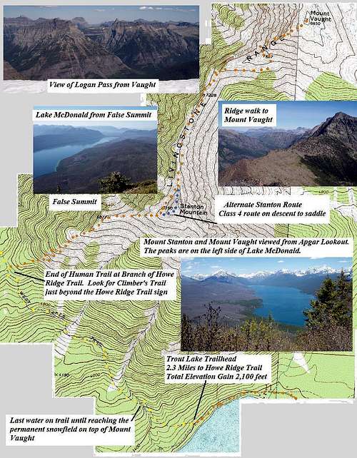
![Mount Vaught Route Overview]() Mount Vaught Route Topo
Mount Vaught Route Topo
Trail Directions: Total Elevation Gain This Leg: 1,920 feet
Follow the Trout Lake Trail 2.3 miles from the trailhead to the junction of the Howe Ridge Trail.
Off Trail Directions: Total Elevation Gain This Leg: 4,480 feet
Follow the excellent route description to Stanton Mountain written by the photohiker and saintgrizzly to the scree field below Stanton’s west cliffs. Other routes to Stanton are available and would achieve the same objective. The contributors follows saintgrizzly and photohiker's route to Stanton.
From here you must decide on one of two routes.
Option 1: Continue to the summit of Stanton and descend the Class 4 pitch (Easily climbed if you have experience climbing in Glacier).
Option 2: Walk below Stanton's west cliff on the scree field
![Stanton from Mount Vaught]() View of Stanton and the route from the summit of Vaught
View of Stanton and the route from the summit of Vaught
Option 1: Navigating the Class 4 pitch on Stanton’s Northwest Ridge:
After a brief rest on the summit while swatting the annoying black flies, gnats and flying ants study the route to Vaught.
![Class IV Blockage on Stanton]() Class 4 Block on Stanton's NW ridge
Class 4 Block on Stanton's NW ridge![Class IV Blockage on Stanton]() Class 4 Block on Stanton's NW ridge
Class 4 Block on Stanton's NW ridge![Class IV Blockage on Stanton]() Class 4 Block on Stanton's NW ridge
Class 4 Block on Stanton's NW ridge
The first task is to follow the northwest ridge of Stanton to the saddle between Stanton and Vaught. It is during this initial leg that a Class 4 cliff must down climbed. Enjoy easy class 2 and 3 scrambling down the ridge until a blockage is reached. This blockage is easily found about halfway down the ridge and is obvious because the normal route is along the ridge top until meeting a 15 foot wall that drops. It looked possible to down climb this wall if belayed, but an easier solution is to look to the right and down climb through a dihedral. Two or three easy moves are needed to reach a ledge that is about 10 feet below the starting point. From there follow a ledge for about 15 feet back to the main ridge and continue down to the saddle. The are good holds in this area for these moves. A belay would be helpful if you feel uncomfortable. The rope could be left at the bottom of the ridge and picked up on your return.
![Stanton Scree Slope]() The scree field below Stanton's summit, (this photo is on the return route after summiting Vaught, Stanton is on the right side of this photo)
The scree field below Stanton's summit, (this photo is on the return route after summiting Vaught, Stanton is on the right side of this photo)
Option 2: Follow Stanton's West Scree Slope to Avoid the Class 4 climb:
An alternate Southwest Ridge Route via Stanton West Scree Slope approach is available. If desiring to avoid the class 4 pitch it is possible to skirt underneath Stanton’s west cliffs at about the 7,000 foot level and complete the remainder of the route as described by Edwards. If choosing this route the climber avoids gaining and loosing 150 feet.
![Stanton-Vaught Goat Trail]() Goat Trail
Goat Trail
The Goat Trail:
No matter if you choose option 1 or 2 the route rejoins and continues along the goat trail. After reaching the bottom of Stanton’s northwest ridge continue towards Vaught. A goat trail will be found that leads north towards the next saddle. There are a few knobs and cliffs along this ridge and the walk along the goat trail below the cliffs is uncomplicated to say the least. Eventually the goat trail disperses and Edwards describes the correct route as “the head of the stream valley near the bottom of the southwest ridge of Vaught (p. 74).” This was confusing while we sat on Stanton so just aim for the low point along the ridge.
It would be helpful to mark this spot with a GPS when the climb to attain the ridge goat trail is started.
![Mount Vaught]() A scree field that lead to Vaught's ridge
A scree field that lead to Vaught's ridge
Attain the Ridge:
From the low point navigate through the cliffs to the goat trails that follow the ridge. Pick the path of least resistance and continue along the eastern side (McDonald Creek side) of the ridge. There are numerous options for ascending on the eastern aspect of the ridge to the spot where the transition to the west side of the ridge depending upon desired challenges for climbing.
Upon reaching the goat trails along the ridge mark this location well using a GPS breadcrumb or cairn for your descent.
![Mount Vaught]() Initial portion on west face
Initial portion on west face![Mount Vaught]() Taken from the point marked 7,587 feet on the topo. This photo is looking down at the area that leads to the transition to the west ridge of Vaught. The large wall is on the left of this photo. Descent route is found on the visible side of the black rib that is leading down the slope.
Taken from the point marked 7,587 feet on the topo. This photo is looking down at the area that leads to the transition to the west ridge of Vaught. The large wall is on the left of this photo. Descent route is found on the visible side of the black rib that is leading down the slope.
Transition to western side of ridge: Photos above
It is not difficult to determine when to transition to the western side of Vaught. When ascending the eastern side a large looming wall is met. Although there probably are other routes to the summit it is an easy transition from this point to the west side. This occurs at about the 7,587 foot level that is seen on the topo map.
Approximate GPS Coordinates of the transition point:
Latitude: 48.67643.
Longitude: -113.88155
![Vaught False Summit]() False summit on Vaught
False summit on Vaught
Last 1,000 feet:
Scrambling to the summit is straightforward through the scree fields after a brief interlude of class 2/3climbing for about 200 feet. The remaining 800 feet is through a boulder field that presents few challenges. The false summit seems to crush hopes of quickly reaching the summit of Mount Vaught but continue onward and upward and in just a few more minutes the true summit will be reached.
Upon reaching the summit be prepared to be overwhelmed with incredible views; but remember that you still have an arduous (read tortuous if you are not in shape) descent to the trailhead. Do not linger too long.
![Descending from Vaught]() Descending from Vaught. The black rib of rocks is on the climber's left, continue to descend until an easy transition back to ridge goat trail is found.
Descending from Vaught. The black rib of rocks is on the climber's left, continue to descend until an easy transition back to ridge goat trail is found.
The Return:
Backtrace the route to the west face transition point. Then aim towards the rib of black rocks and follow that rib while looking for an easy transition to the goat trail alone the ridge. Be cautious to not go too far along the ridge on the goat trails. A GPS would be helpful for identifying this crucial transition. By following the ridge too far one will find themselves in class 3 or 4 cliffs instead of easy class 2 descent. Follow the goat trail back to Stanton's northwest ridge.
Edwards suggests bringing flashlights and leaving them on Stanton where they could be picked up on the return (p. 75). More than likely you will not have time or the desire to summit Stanton again if you already climbed it or you have decided to avoid the Class 4 cliff. An alternate suggestion would be to leave unneeded items at the bottom of Stanton’s northwest ridge and pick them up on the return.
Returning via Stanton’s West Scree Slope is quite easy. Upon reaching the low point of Stanton northwest ridge proceed West under the cliffs on the scree fields. In about ½ mile the climber’s route for Stanton will be reached and then back trace your route down to the human trail. We found that the climber’s trail is closer to the ridge then we thought it was and initially had difficulty find the climber’s trail.Essential Gear
◊ Bear Deterrent Spray since this is grizzly country.
◊ Water to cache along the route
◊ Insect spray if climbing Stanton
◊ GPS to mark waypoints along trail for return route.
◊ Climbing poles for support during ascent and descent
◊ Climbing rope for belay on class 4 pitch???
◊ Mountaineering gear including an ice axe and crampons if an early season climb is planned
Weather, Camping and Topo
See the Mount Vaught main page for links for weather, camping as well as other important information such as Red Tape, External Links and When to Climb.

 Mount Vaught Route Topo
 View of Stanton and the route from the summit of Vaught
 Class 4 Block on Stanton's NW ridge Class 4 Block on Stanton's NW ridge |
 Class 4 Block on Stanton's NW ridge Class 4 Block on Stanton's NW ridge |
 Class 4 Block on Stanton's NW ridge Class 4 Block on Stanton's NW ridge |
 The scree field below Stanton's summit, (this photo is on the return route after summiting Vaught, Stanton is on the right side of this photo)
 Goat Trail
 A scree field that lead to Vaught's ridge
 Initial portion on west face
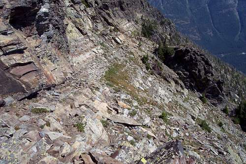 Taken from the point marked 7,587 feet on the topo. This photo is looking down at the area that leads to the transition to the west ridge of Vaught. The large wall is on the left of this photo. Descent route is found on the visible side of the black rib that is leading down the slope.
 False summit on Vaught
 Descending from Vaught. The black rib of rocks is on the climber's left, continue to descend until an easy transition back to ridge goat trail is found.

|
|---|