

-
 21167 Hits
-
 89.01% Score
-
 28 Votes
|
|
Mountain/Rock |
|---|---|
|
|
48.68056°N / 113.87458°W |
|
|
Flathead |
|
|
Summer, Fall |
|
|
8850 ft / 2697 m |
|
|
Overview:
Layout designed for best viewing on a "1024 x 768" screen.
Montana's Mount Vaught is part of a four mountain chain above McDonald Creek. These peaks are difficult to see while driving along the road besides McDonald Creek. By stopping along the road one will be rewarded with interesting views as well as intimidated by the grand scale of these four mountain. This string of mountains include: Stanton Mountain , Vaught, McPartland and Heaven's Peak .
There are a few intrepid mountaineers who have summitted all four of these in one day. Those people are ANIMALS! To do one of these peaks in a day is a long day and to summit all of them is an incredible feat.
Mount Vaught is part of the Livingston Range and is located approximately 3 miles north of the inlet to Lake McDonald on the west side of the continental divide in Glacier National Park. Incredible views await those who make it to the summit.

|
|---|
360 degree views including:
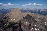
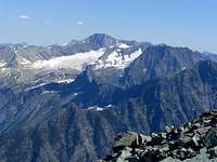
◊ To the northeast, The Garden Wall and beautiful Mount Gould punctuate the skyline.
◊ In the far distance to the north, lie the Lewis Range and massive Mount Cleveland and Mount Merritt.
◊ To the northwest, the Livingston Range with Longfellow Peak blocking part of the views
◊ To the west, the Camas Drainage and Arrow, Trout and Rogers Lakes.
◊ To the south, shimmering Lake McDonald and the Flathead Valley.
◊ The Great Bear Wilderness and Great Northern Mountain lie to the southeast as do the peaks of the Nyack region.
◊ The Sperry Glacier Basin and Gunsight and Edwards Mountains dominate the sky to the east
◊ And finally the Hidden Lake is held in by the peaks surrounding Logan Pass.
 The Garden Wall The Garden Wall |
 Lewis Range Lewis Range |
 Livingston Range Livingston Range |
 Camas Drainage Camas Drainage |
 Lake McDonald and The Great Bear Wilderness Lake McDonald and The Great Bear Wilderness |
 Sperry Glacier Basin Sperry Glacier Basin |

|
|---|
Views Of Mount Vaught: Move cursor over photo for more information or click on photo to follow link on photo for more information.

|

|

|
|---|---|---|

|

|

|

|

|

|
An Introduction to Mount Vaught
Back then……
According to Place Names of Glacier National Park by Jack Holterman, Mount Vaught was called the "Big Old Man," or Kwilqa Nul, by the Kootenai Indians.
The first recorded climb of the mountain known today as Vaught was in the late 1890’s or early 1900’s by L. O. Vaught, a prominent attorney from Jacksonville, Illinois, who spent his summers in the park for many years.
Around 1895, L. O. Vaught was apparently involved along with one of the Commissioners of Indian Affairs, Walter M. Clements, and other notables including George Bird Grinnell and William C. Pollock in negotiations with the Blackfoot Nation regarding the “Ceded Strip”. These names are associated with Glacier National Park’s early history as well as a number of mountains. Vaught was a major player in establishing Glacier National Park.
|
The “Ceded Strip” was established in 1895 by Congressional approval in an agreement with a number of Blackfoot chiefs representing the Tribe. This land was called “The Backbone of the World” by the Blackfeet and the agreement reduced their lands by 800,000 acres. The Blackfeet sold this land for $1.5 million. The “Ceded Strip” consists of land along the west side of the Blackfeet Reservation, from the crest of the Continental Divide east to the foothills, using the center high points of Chief Mountain and Heart Butte as key references for the north and south ends. According to the agreement the Blackfeet Tribe would designate the land public domain and agreed to follow the laws of the State of Montana regarding hunting and fishing. They were allowed to harvest wood for personal uses as well as for development of the community. In 1897 the “Ceded Strip” became part of the Federal National Forest and it became part of Glacier National Park when the park was established in 1910. |
In a 2005 letter to then Montana U.S. Senator Conrad Burns, Edward V. Foreman wrote that his great-uncle, L.O. Vaught, came into the Glacier Park area in 1894. He knew George Bird Grinnell and Lyman Sperry, as well as most of the old-timers in the Belton, Apgar, and Lake McDonald area. According to his great-nephew, Vaught was an enthusiastic supporter of preserving the wilderness.
Vaught was influential in his hometown and acted as the catalyst to bring a Carnegie Library to his hometown. He wrote a letter to Andrew Carnegie requesting funds for its construction.
And Now…………Climb Me If You Can!

|
|---|
Mount Vaught laughs at climbers as we travel up McDonald Creek along the Going-to-the-Sun Highway. It mocks us as we head for places with trailheads that start at higher elevations and complete climbs with less than 3,000 feet in elevation gain. For example, the incredible Reynolds Mountain is a 5.5 mile round trip with 2,500 feet elevation gain and requires a half day’s work. This unassuming peak taunts us when viewed from the peaks at Logan Pass, “Climb me if you can!”
A route to the summit of Mount Vaught can be found in Volume 3 of Climb Glacier National Park. Find it when you arrive in the area from local retailers or order it from the author on line at Volume Three.
Mount Vaught is a featured peak in J. Gordon Edwards’ A Climber's Guide To Glacier National Park and the route description is located on pages 74 and 75.
Edwards describes the total distance to the summit one-way as 6.5 miles and reported a total elevation gain from the trail head to the summit of 5,650 feet. This elevation gain includes climbing Stanton Mountain en-route. According to modern topo maps the elevation gain is greater than Edwards has recorded in his description, but more about that later.
Edwards reports that this climb is a hard day’s work for most people and recommends leaving the trailhead no later than 7:00 a.m. He also suggested bringing flashlights and leaving them on Stanton for the descent. The contributors of this page agree with his opinion, it is a long day.
The route highlighted on this page generally follows Edwards’ Southwest Ridge Route approach to Vaught. An alternate route for those who prefer not to challenge themselves with the class 4 descent from Stanton is also available.
Getting There:

|
|---|
| To visit Glacier National Park is to enter a place where Heaven touches Earth affording brief glimpses into the Wonders of Creation. |
Glacier National Park’s Mount Vaught is located in Northwest Montana. The locals all say, "Have a nice VISIT in Montana". While you are visiting check out other things to do at Things To Do In The Flathead Valley.
Montana is a long way from most places. That’s why many of us live here. It is possible to get here.
By Air: Glacier International Airport serves as the air hub for northwestern Montana. Horizon, Delta Connection and Northwest Airlines service this area.
By Bus: Northwest Montana is served by bus service.
By Rail: Amtrak arrives daily from Minneapolis or Seattle stops in East Glacier, Essex, West Glacier and Whitefish.
By Road: The major highways serving northwest Montana include U.S. Highway 2 running east and west and running north to south are U. S. Highway 93 and Montana Highway 83. Glacier National Park is located 160 miles north of Interstate 90 which runs through the southwestern portion of Montana.
Rental cars can be secured in the Flathead Valley at and near Glacier International Airport. See Car Rentals in Montana.
Glacier’s Shuttle System;
Glacier’s shuttle system will not be a benefit on this route since the trailhead is not served by the shuttle system. The information in this section is provided for the reader if considering additional climbs or trips in Glacier National Park.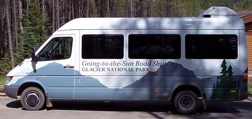 Glacier Shuttle
The 2010 shuttle system runs from July 1 to September 6, 2010.
Glacier National Park began offering a FREE shuttle service in 2007. This is a great option for exploring the park. The shuttle runs the entire Going-to-the-Sun Highway from St. Mary on the eastern border of Glacier to Apgar, near Lake McDonald, on the park’s western boundary. Some climbs are close enough to the shuttle route and are short enough in time requirements to allow use of the shuttle service. Piegan is one such climb. The earliest shuttle’s depart from Apgar at 7:00 a.m. and generally take 1.5 to 2 hours to reach Logan Pass due to road construction on the Westside of the Logan Pass.
Trips from St. Mary are generally less lengthy and take an average of 60 minutes from St. Mary to Logan Pass. The first shuttle departs St. Mary at 7:00 a.m. The last shuttles depart from Logan Pass at 7:00 p.m.
The Park Service recommends being prepared to wait for shuttles with proper clothing, foot gear, water, snacks and other gear such as sun screen.
See the Glacier National Park’s website for more information at Shuttle Service.
Red Tape:
For all of the rules and regulations for Glacier National Park please visit the park website.Vehicle single entry fee for Glacier National Park is $25.00 for 7 Days, $12.00 per person for single hiker, motor biker or bicyclist. An "America The Beautiful Federal Lands Recreational Pass" for goes for $80.00 which gives entrance to all National Parks, National Forests, BLM, US Fish & Wildlife, and Bureau of Reclamation sites for one year from date of purchase. See Plan Your Visit for other information regarding all of the National Park entrance fee information.
If you are planning on visiting Waterton Park make sure you have a passport to simplify crossing the border.
You do not have to register for day climbs in Glacier National Park but it is recommended. Backcountry travel regulations can be found at Backcountry Travel. There is also information from the Park Service on Mountain Climbing in Glacier.
Route Information and Statistics:
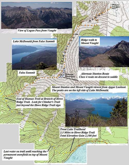 Mount Vaught Route Topo
 Vaught Route
Details of route information for Mount Vaught can be found on the Southwest Ridge Route page.
In his excellent Southwest Ridge Route description J. Gordon Edwards includes summiting Stanton on this route. It is possible to do this but a class 4 pitch must be negotiated while descending from Stanton to the saddle between Stanton and Vaught.
An alternate Southwest Ridge Route and West Scree Slope to Vaught Saddle approach is available. If desiring to avoid the class 4 pitch it is possible to skirt underneath Stanton’s west cliffs at about the 7,000 foot level and complete the remainder of the route as described by Edwards. ratings for this route are Class 2 and 3.
One Way Distance to Vaught’s summit
2.3 miles on Human Trail from Trout Creek Trailhead to Howe Ridge Junction.
3.9 to 4.2 miles of class 2 or 3/4 scrambling depending upon route
Elevation Gains En-route to Vaught’s Summit (does not include descent):
Vaught without summiting Stanton Mountain:
Trout Lake Trail Head: 3,200 feet (975 meters elevation)
Trailhead to Climber’s Trail: 5,120 feet (1,920 feet or 585 meters gained)
Climber’s Trail to Stanton Goat Trail below west cliffs: 7,600 feet (2,480 feet or 756 meters gained)
Low point on Vaught Saddle above McDonald Creek: 7,000 feet (700 feet or 213 meters lost)
Vaught Summit: 8,850 feet (1,850 feet or 564 meters gained)
Total Elevation Gained: 6,250 feet or 1,935 meters
Total Elevation Lost: 700 feet or 213 meters
Vaught with summiting Stanton Mountain:
Beginning elevation at Trout Lake Trail Head: 3,200 feet (975 meters)
Trailhead to Climber’s Trail: 5,120 feet (1,920 feet or 585 meters gained)
Climber’s Trail to Stanton Summit: 7,750 feet (2,630 feet or 802 meters gained)
To Low point on Vaught Saddle above McDonald Creek: 7,000 feet (750 feet or 228 meters lost)
Vaught Summit: 8,850 feet (1,850 feet or 564 meters gained)
Total Elevation Gained: 6,400 feet or 1,951 meters
Total Elevation Lost: 750 feet or 228 meters
When to Climb:

|
|---|
When to climb Mount Vaught presents an interesting conundrum. Because of its length and massive elevation gain timing this ascent is crucial to be successful. The options are: (A) To climb early and deal with snow or (B) climb late and deal with a long hot, dry route.
Early summer 2008 climbers report large amounts of snow remaining in the basin between Stanton and Vaught that may require advanced snow skills. Unless experienced in snow travel consider a later climbing date for Mount Vaught. Before climbing inspect the ridge and route upon reaching Stanton.
If climbing in July and August be prepared to deal with a dry long route with massive amounts of elevation gain for Glacier National Park. The down climb from Vaught to the Trout Lake Trail near Howe Ridge is brutal on the quads and feet. It is recommended to cache water along the route for the descent.
Perhaps the most logical time to climb is late August or early September when the temperatures cool and Montana usually is enjoying what we call “Indian Summer” (my apologizes to any Native Americans). If you wait too long the risk of skiffs of snow increases as does poor weather. It is all an issue of timing.
For example: In late August 2008 snow came early to Glacier and shut down climbing above the 6,000 foot level until September and then climbing was great until the middle of October. The snow melted and summits were climbed again.
Camping:
 Camp Only In Established Campgrounds
There is no camping available at The Trout Lake Trailhead. The closest campground is Sprague Creek. The cost for this tent camping only campground is $20.00 per night.
Apgar campground is the largest campground in Glacier National Park. It is near Apgar Village, where you will find the Apgar visitor center, gift shops, a camp store, and a casual restaurant. Horseback ride reservations, boat rentals, a shuttle service, and Red Bus tour reservations are also located in Apgar Village.
Apgar Campground is open for primitive camping April 1 through May 1 and again in the Fall from October 14 through November 30. Primitive camping is $10.00 per night.
There is also a campground at Fish Creek Campground which is near Apgar. Fish Creek campground is located just off the Camas Road approximately 2.5 miles from Apgar Village on the west side of Glacier National Park. It is the second largest campground in the park.
Lake McDonald Lodge is also close and there are restaurants, a store and gift shop there as well.
Other options for camping include:
GNP Campground Information
USFS Campgrounds.
Weather:

|
|---|
Montana gets its share of interesting weather. On June 8, 2008 over 2” of snow fell in the Flathead Valley and up to 24” inches of new snow in the Glacier National Park high country.
In some years there is record snowfall in the mountains of western Montana. In the recent years all of the northwest Rocky Mountains have been under severe drought conditions. The winter of 2007-2008 finally broke that string of low snow and there is still snow lingering in the high country in spots that usually don’t have snow in mid summer.
Equipment:
Crucial gear includes: bear deterrent spray, extra water, sturdy footwear and a camera. Also plan on taking longer than expected so additional electrolytes and calories would be beneficial.In addition to lots of water remember to bring more water! There is water available on the trail approximately ¾ mile from the Trout Lake Trailhead make sure you have a water filter unless you want to get giardia. There is also a snow field at the summit of Vaught where it is possible to melt snow if necessary.